Site Possibilities
What can be built at 7 Hartwig Crescent, Mount Warren Park
7 Hartwig Crescent Mount Warren Park QLD
A new dwelling on a constrained lot: the mapped constraints subtracted, the buildable envelope measured and the house placed, for 391RP890528
- Report reference
- CI-20260915-MWP
- Issued
- 15 September 2026
- Scheme in force
- Logan Planning Scheme 2015 (v9.2 + TLPI No. 1 2024), revision 203 in force 2025-06-25
- Prepared for
- Published as a sample
The answer
You can put a new house on this block, and an approval Council has already granted over this land says where it should go.
Read the next paragraphs before you rely on that: every comparable house on this corridor that appears in Council's register, including the one next door, was approved through a development application, not through the no application route, and Council's approval does not say whether that route is open on this lot before the plan of survey registers, a question this report has not put to Council. A development permit granted by Logan City Council over this land on 2023-01-18 (COM/6/2022) fixed four development envelope areas, two vegetation covenants, bushfire no dwelling zones and a shared access easement. Once every one of those exclusions and the boundary setbacks are subtracted from the 3,060.85 m2 parcel, 1,406.1 m2 of ground is left to build on, and 715.9 m2 of that sits inside an approved envelope: 376.0 m2 at the front of the lot and 339.9 m2 in the middle. Three of the mapped layers you named are not subtracted, because they do not stop a building standing there: the biodiversity corridor, the vegetation management area and the steep slope area are shown but not deducted, and section 7 says what each of them requires instead. A 121.5 m2 house drawn to scale in the front envelope keeps 12.9 m to Hartwig Crescent and west 2.9 m, east 6.3 m, rear 65.7 m, and covers 4.0% of the 3,061 m2 lot.
What the mapping withholds is the freedom to put the house anywhere else. The biodiversity corridor covers 100% of the lot, so outside those approved envelopes the acceptable outcome that asks a house to sit outside a corridor is not met, and a house there needs a code assessable application to Council supported by a detailed ecological assessment. Every position on the lot, approved envelope or not, still needs a site specific geotechnical report by an engineer, bushfire construction to the Australian Standard, and a separate building approval; the ground falls 27.7 m across the lot and 94% of it is steeper than 15%.
The single fact that shapes everything: that live approval is running out before the house is. As at today, 15 September 2026, the reconfiguration part of COM/6/2022 has about 4 months left (to 18 January 2027, 125 days) and the operational works approval about 7 months (to 29 April 2027, 226 days). Registering the plan of survey is what turns the four envelopes into four lots, and it is also what settles, beyond argument, that a house built inside an envelope is inside a development envelope area approved by a development approval.
3,063 m2
Lot area
1,406.1 m2
Residual buildable envelope
715.9 m2
Inside an approved envelope
32% mean slope
Ground
Summary
You asked what it takes to place a new dwelling on a constrained block, with every mapped constraint subtracted and the house drawn inside what is left. We read the planning scheme in force for Logan today, queried Council's own mapping against the cadastral boundary of 391RP890528 across 293 layers, read the development permits Council has already granted over this land and 20 nearby applications, 19 of them decided, and measured the geometry on the State cadastre, the 1 m LiDAR ground model and the approved plans. 5 pathways were tested, each against the acceptable outcomes of the code that applies, and the buildable envelope and the house were drawn to scale on the measured geometry.
- Address
- 7 Hartwig Crescent Mount Warren Park QLD
- Lot / plan
- 391RP890528
- Local government
- Logan
- Zone
- Low density residential
- Site area
- 3060.85 m²
- Overlays
- OM-02.02 Biodiversity corridor (Regional Corridors), OM-02.01 Secondary vegetation management area, OM-02.04 Matters of state and local environmental significance, OM-03.00/03.01 Bushfire hazard: potential impact buffer 100%, very high potential 9.3%, OM-08.00/08.01 Landslide hazard and steep slope (>=15%), OM-10.00 Residential overlay
What the land allows
The short answer, pathway by pathway
1. A new house inside the approved front development envelope (the Lot 6 envelope, 376.0 m2 of buildable ground after the boundary setbacks). Inside an approved envelope the overlay acceptable outcomes about the biodiversity corridor and native trees are satisfied by the location itself, so the change of use sits in the category the tables give a house in this zone: accepted development, subject to the requirements of the Dual occupancy and Dwelling house code (Table 5.10.10.1 of the Residential overlay, rule 23329, read against section 9.3.2). That means no development application to Council for the use, provided every acceptable outcome listed in section 9.3.2 is met, including the geotechnical report with cut and fill kept to 40 m3 or less, the setbacks, the 50% site cover and the bushfire plan, and provided Council confirms in writing that the approved envelope can be relied on before the plan of survey is registered (the open question carried in the risk register); a building approval, bushfire rated construction and an approval for the earthworks are separate and still required. Our drawn test fit meets the acceptable outcomes that can be measured from mapping, which are the boundary clearances and the site cover: 12.9 m to the road, west 2.9 m, east 6.3 m, rear 65.7 m, site cover 4.0% of the 3,061 m2 lot and 18% of the future Lot 6 (669 m2). Every other acceptable outcome of the code turns on a design, a level or a report that does not exist yet, and none of them is tested here.
2. The same house in the approved middle envelope (the Lot 5 envelope, 339.9 m2 buildable). Same category, same conditions, harder ground: 3.77 m of fall under the footprint against 2.73 m at the front, a 32.7 m driveway instead of 16.0 m, and the higher bushfire construction level.
3. A house anywhere else on the lot. The biodiversity corridor covers 100% of the land, so the acceptable outcome that asks a house outside an approved envelope to be located outside a corridor is not capable of being met. The use then becomes code assessable, limited to that subject matter, and is judged against the performance outcome with a detailed ecological assessment (PO21 of the Dual occupancy and Dwelling house code, section 9.3.2, rule 15144). 14 houses within about 250 m were approved as code assessable changes of use on these overlays, every one of them read from Council's own documents, and in 11 of those Council's written reasons deal with the biodiversity corridor under the performance outcome; the other 3 carry slope or road boundary reasons only. No refusal of a house appears in the 300 register records the 2 km query returned, which is the cap the query was run at, so the register was not read to its end.
4. Act on the approved subdivision. COM/6/2022 and the operational works approval OW/47/2024 are in effect: as at today, 15 September 2026, about 4 months (reconfiguration, to 18 January 2027, 125 days) and about 7 months (operational works, to 29 April 2027, 226 days) remain. Registering the plan of survey creates the four lots (Lot 6 at 669 m2, Lot 5 at 612 m2, Lot 3 at 725 m2 and Lot 4 at 1,055 m2 as printed on the approved plan) and puts each house on its own title inside its own envelope.
5. A second, smaller dwelling (an auxiliary unit) with the house. The scheme allows it as accepted development subject to requirements, but Council's own condition confines auxiliary units to the future Lots 4 and 5 and only after the survey plan is registered. We have not drawn a test fit for two dwellings, so no yield is claimed here.
Note
Accepted development means no development application to Council for the use itself, provided every acceptable outcome in the code is met. It never means no approvals at all: a building approval under the Building Act, construction to the bushfire standard, and an approval for earthworks where retaining passes the thresholds are all separate and all still apply.
Scope and method
What we were asked, and how it was answered
You asked for this, in your words: "Sample report for placing a new dwelling on this constrained site: subtract every mapped constraint (bushfire, landslide, environmental and biodiversity overlays, setbacks, easements, access) from the parcel as hatched exclusion zones, give the residual buildable envelope with its area in m2, and place the dwelling optimally inside it, drawn to scale, each figure cited. State the constraints plainly and never assert a pathway the overlays withhold; give the AO-compliant answer and what would rely on a performance outcome."
That was answered in four steps. First, the instrument in force was read from Council's own electronic scheme on the day of this report: Logan Planning Scheme 2015 (v9.2 + TLPI No. 1 2024), revision 203 in force 2025-06-25, and every provision this report turns on was taken down verbatim with its rule number. Second, Council's mapping was queried layer by layer with the cadastral boundary of 391RP890528, 293 layers in all (40 returned a feature on the lot, 252 came back clear and 1, house numbers, could not be queried), and each hit measured as a share of the lot after the layer's own classes were combined. Third, Council's decisions over this land and nearby were read from Council's own decision notices, conditions, information requests and stamped plans, not from the register summary. Fourth, the geometry was measured: the State cadastre for the boundaries, the State 1 m LiDAR for levels and slopes, 2022 State aerial imagery at 10 cm for canopy and the absence of a crossover, and the approved plan of development reconstructed on the cadastre from its printed dimensions so the envelopes, covenants and easements could be drawn and measured.
What was not done, and matters. There was no site inspection. No title search was obtained, so what the title carries is unknown. No survey was commissioned, so every boundary and level in this report is from mapping and is subject to survey. No geotechnical, ecological or bushfire investigation was carried out. No design work is included: the house drawn is a test module, not a plan. A separate Site Analysis Plan accompanies this report at larger scale, showing the existing conditions and the setback envelope; the hatched exclusions, the residual buildable envelope and the placed dwelling are drawn at figure scale in section 7.
Particulars
The site
The lot is a long, steep, bush fringed block on the western side of Hartwig Crescent, backing onto Council conservation land in the Environmental management and conservation zone. It is vacant on the 2022 imagery, with no dwelling on it. The front third is cleared grass with a track and a parked vehicle on the imagery; the middle carries scattered trees and the rear and eastern side are continuous bushland with the neighbours. To the west, 9A Hartwig Crescent has a house and 9 Hartwig Crescent has an approval. There are no easements recorded on the cadastre for the parent lot and no flood, heritage, acid sulfate, noise or airport mapping over it.
| Item | As read today |
|---|---|
| Lot and plan | 391RP890528 |
| Area (DCDB polygon) | 3060.85 m2 |
| Area (registered) | 3063.0 m2 |
| Frontage | 17.99 m to Hartwig Crescent |
| Depth (about) | 92.52 m |
| Corner lot | no |
| Easements on the DCDB | 0 |
| Zone | Low density residential |
| Precinct | SU - Suburban |
| Local plan | none mapped |
| Ground (LiDAR) | RL 36.05 to 63.77 m AHD, mean slope 32.08% |
| Title | not searched; covenants and encumbrances unknown |
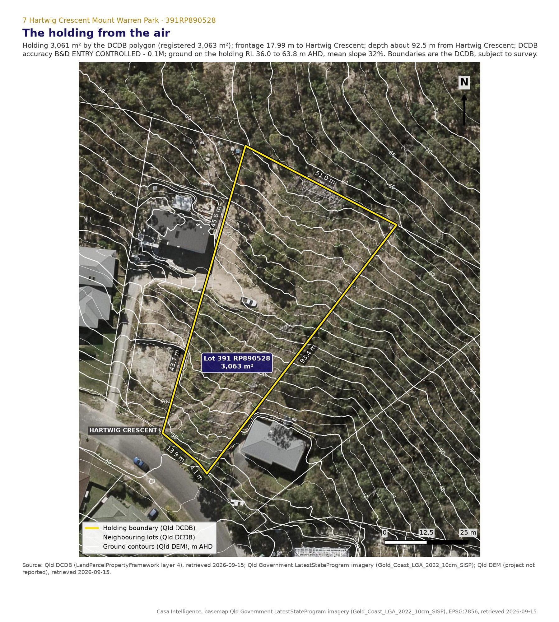
Holding 3,061 m² by the DCDB polygon (registered 3,063 m²); frontage 17.99 m to Hartwig Crescent; depth about 92.5 m from Hartwig Crescent; DCDB accuracy B&D ENTRY CONTROLLED - 0.1M; ground on the holding RL 36.0 to 63.8 m AHD, mean slope 32%. Boundaries are the DCDB, subject to survey.
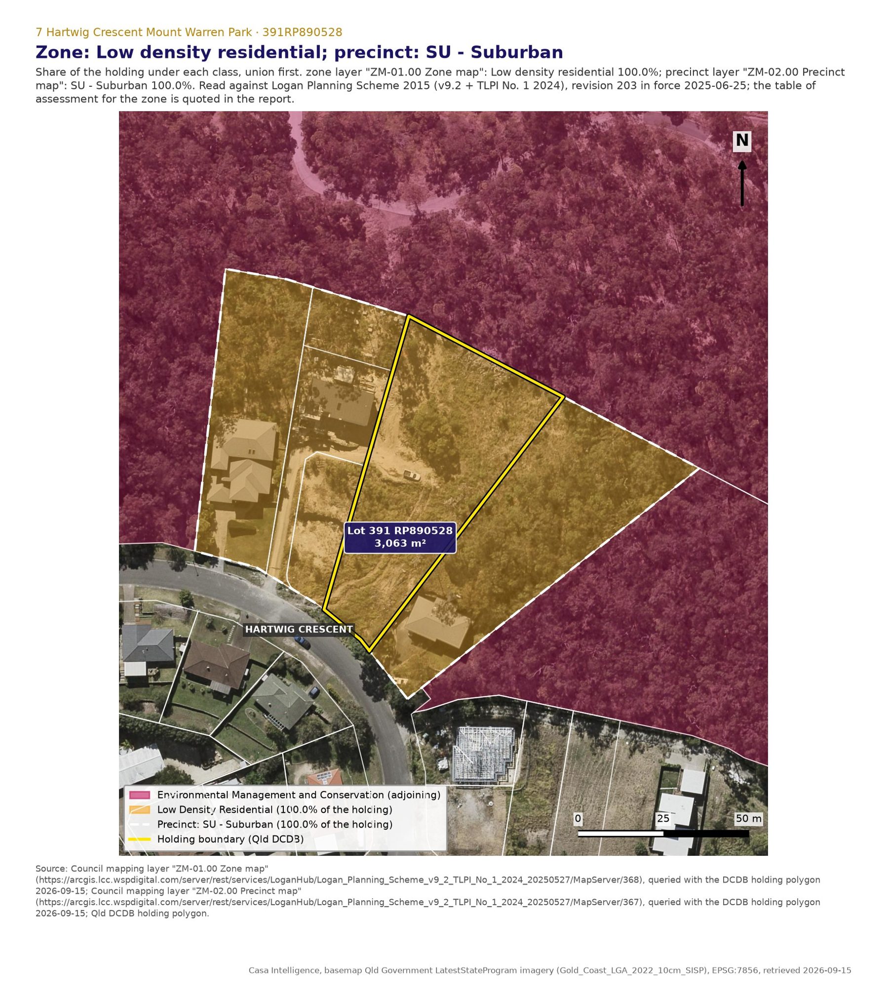
Council mapping layer "ZM-01.00 Zone map" (https://arcgis.lcc.wspdigital.com/server/rest/services/LoganHub/Logan_Planning_Scheme_v9_2_TLPI_No_1_2024_20250527/MapServer/368), queried with the DCDB holding polygon 2026-09-15; Council mapping layer "ZM-02.00 Precinct map" (https://arcgis.lcc.wspdigital.com/server/rest/services/LoganHub/Logan_Planning_Scheme_v9_2_TLPI_No_1_2024_20250527/MapServer/367), queried with the DCDB holding polygon 2026-09-15; Qld DCDB holding polygon.
What the scheme says
The framework, and the categories, quoted
The instrument in force is the Logan Planning Scheme 2015 (v9.2 + TLPI No. 1 2024), revision 203 in force 2025-06-25, read on the day of this report. The land is in the Low density residential zone, Suburban precinct. There is no local plan over it. Four overlays touch it: Biodiversity areas, Bushfire hazard, Landslide hazard and steep slope area, and the Residential overlay.
Table 5.5.5.1 of the zone lists a Dwelling house as accepted development (not subject to requirements). The Residential overlay table then lifts it one notch: for a dwelling house in a residential area the category is accepted development (subject to requirements), assessed against the 9.3.2 Dual occupancy and Dwelling house code (rule 23329). The Biodiversity, Bushfire and Landslide overlay tables each record no change for a house and its building work (rules 15042, 23890, 15078, 23894, 15105, 23909); their benchmarks for a house are carried inside section 9.3.2 itself, which is why that one code decides this site (rule 15144).
What accepted development subject to requirements means, in the scheme's own words: "Accepted development that does not comply with one or more of the nominated acceptable outcomes in the relevant parts of the applicable code(s) becomes code assessable development, unless otherwise specified." That single sentence is the hinge of this report. Meet the acceptable outcomes and there is no application for the use; miss one and the application is required, but only about the outcome that was missed.
The acceptable outcomes that decide where the house goes, quoted as read: "AO21 A Dual occupancy (auxiliary unit) or Dwelling house that is not located within a development envelope area approved by a development approval is: located outside a Biodiversity corridor as identified on Biodiversity areas overlay map OM-02.02; located outside the Locally significant Melaleuca irbyana 50 metre buffer area identified on Biodiversity areas overlay map OM-02.03." "AO20 A Dual occupancy (auxiliary unit) or Dwelling house located in the Primary or Secondary vegetation management area identified on Biodiversity areas overlay map OM-02.01, that is not located within a development envelope area approved by a development approval: is located to avoid the need to clear any native vegetation in the Primary vegetation management area; is located to avoid the need to clear any native trees or native habitat trees in the Secondary vegetation management area." "AO27 Where a Dual occupancy (auxiliary unit) or Dwelling house is proposed to be located in a Steep slope area identified on Landslide hazard and steep slope area overlay map OM-08.00 and the gradient is equal to or greater than 12 percent or located in a Historical landslide area identified on Landslide hazard and steep slope area overlay map OM-08.01: development is carried out in accordance with a site specific geotechnical report: prepared in accordance with section 2.2.6 of Planning scheme policy 5 - Infrastructure and is provided to the local government; that assesses the suitability of the proposed development based on existing geotechnical conditions of the site; that identifies all risk mitigation measures required to ensure the development remains geologically stable in the long term; that includes a certification by a Registered Professional Engineer of Queensland specialising in geotechnical engineering that the development the subject of the report has a factor of safety greater than 1.5 against geotechnical failure; development does not involve cut and fill of more than 40m3; development is designed to ensure that the undercroft of the building or structure has: skirting or landscape screening to the full height of the undercroft; a maximum height at the perimeter of the building or structure of 3 metres above ground level." "AO16 Filling and excavation works involving batters and retaining walls greater than 1 metre in height from ground level are designed and constructed in accordance with section 3.3 - Filling and excavation standards of Planning scheme policy 5 - Infrastructure" The zone code adds "AO2 A building on a slope of: less than 15 percent has a maximum building height of 8.5 metres; or 15 percent or more has a maximum building height of 10 metres." and "AO24 Development in the Suburban precinct has a maximum site cover of 50 percent." Setbacks come through the code's first acceptable outcome, which applies the Queensland Development Code acceptable solutions for a lot of 450 m2 or more.
Note
One sentence decides this site. A house that sits inside a development envelope area approved by a development approval satisfies the biodiversity acceptable outcomes by its location alone. A house outside one does not, because the corridor covers 100% of the lot, and the use is then code assessable limited to that subject matter.
What is mapped, and what it does
The overlays, one by one
Council's mapping was queried with the cadastral boundary of this lot, layer by layer, and each hit measured as a share of the holding. Every layer in Council's catalogue that returned nothing is recorded as clear, not assumed clear: acid sulfate soils, flood, heritage, extractive resources, regional infrastructure, airport environs, transport noise, water resource catchments and waterway corridors all came back clear on this lot. Clear mapping is not the whole of it: the approved plan also binds construction on this land in two ways that are not overlay mapping. Every dwelling house built in these envelopes is subject to Noise Category 1 under Queensland Development Code mandatory part MP4.4, which sets the sound insulation of habitable rooms against road traffic noise, and to the bushfire provisions of the National Construction Code. They sit at items 5 and 6 of the development envelope areas list on approved plan sheet 1941-D18G. The State trigger sweep was clear too, with the nearest state controlled road 234.9 m away, no rail corridor, no priority development area and no koala priority area.
Three of the four overlays change nothing about the category of assessment for a house. They change what the house must prove. The one that changes the category is the corridor, and only where the house sits outside an approved envelope. Four further layers returned a feature but change nothing: the environmental management policy's ecological significance figure (FIG-3.1.10.1, score class 22 to 32 over 74.2% of the lot, the map an ecological assessment would be read against), the State core koala habitat and MSES wildlife habitat layers (a 0.3 m2 sliver on the boundary, 0.0% of the lot), the environmental management and conservation area boundary of the reserve behind, and Council's building envelope layer (touching the neighbour's envelope, with no record for this lot).
| Mapped layer or approved exclusion | Share of the lot | What it does to the category of assessment | Read from |
|---|---|---|---|
| OM-02.02 Biodiversity corridor (Regional Corridors) | 100.0% | MCU/BW for a dwelling house: no change (Table 5.10.2.1); 9.3.2 AO21 requires location outside the corridor unless in an approved development envelope area, otherwise code assessable under PO21; clearing native vegetation inside the corridor is code assessable (Table 5.10.2.1.1 fails) | 9.3.2 (AO21), 8.2.2 for other development |
| OM-02.01 Secondary vegetation management area | 74.2% | 9.3.2 AO20: avoid clearing native trees/native habitat trees unless in an approved envelope; clearing <10 native trees accepted subject to requirements (compensatory planting AO3 of 8.2.2), >=10 code assessable | 9.3.2 (AO20); 8.2.2 AO3 |
| OM-02.04 Matters of state and local environmental significance | 100.0% | Both MSES and MLES 74.2%, MSES only 25.8%; governs the offset route if native vegetation is cleared (8.2.2 AO2.1/AO3: Queensland Environmental Offsets Policy) | 8.2.2 |
| OM-03.00/03.01 Bushfire hazard: potential impact buffer 100%, very high potential 9.3% | 100.0% | No change for a dwelling house (Table 5.10.3.1); designated bushfire prone area (AS3959 BAL through building approval); approved BMP exclusion zones and BAL levels bind future dwellings under COM/6/2022 conditions 3.7-3.10 | 8.2.3 for other development; BMP 001.03.22 rev 2 |
| OM-08.00/08.01 Landslide hazard and steep slope (>=15%) | 100.0% | No change for a dwelling house; 9.3.2 AO27 geotechnical report (FoS > 1.5, RPEQ); AO16 retaining walls > 1 m to PSP5; operational work for earthworks outside an approved envelope: 8.2.8 applies (AO3 no cut and fill; AO1 geotech) | 9.3.2 (AO27, AO16); 8.2.8 |
| OM-10.00 Residential overlay | 100.0% | Dwelling house MCU becomes accepted development (subject to requirements) against 9.3.2 | 9.3.2 |
| Approved vegetation covenants D (271 m2) and F (503 m2), COM/6/2022 condition 3.2 (to be registered with the plan of survey) | 25.3% | once registered: no buildings, batters or services in the covenant area (condition 3.2.3) | COM/6/2022 conditions |
| Approved Easement K (5.5 m access, 204 m2 printed on the approved plan, 183.3 m2 as reconstructed on the cadastre) and Easement J (3 m services, 63 m2 printed, 61.3 m2 reconstructed) along the east boundary | 8.0% | access and services reserve; not buildable; not yet registered | COM/6/2022 condition 2.1 |
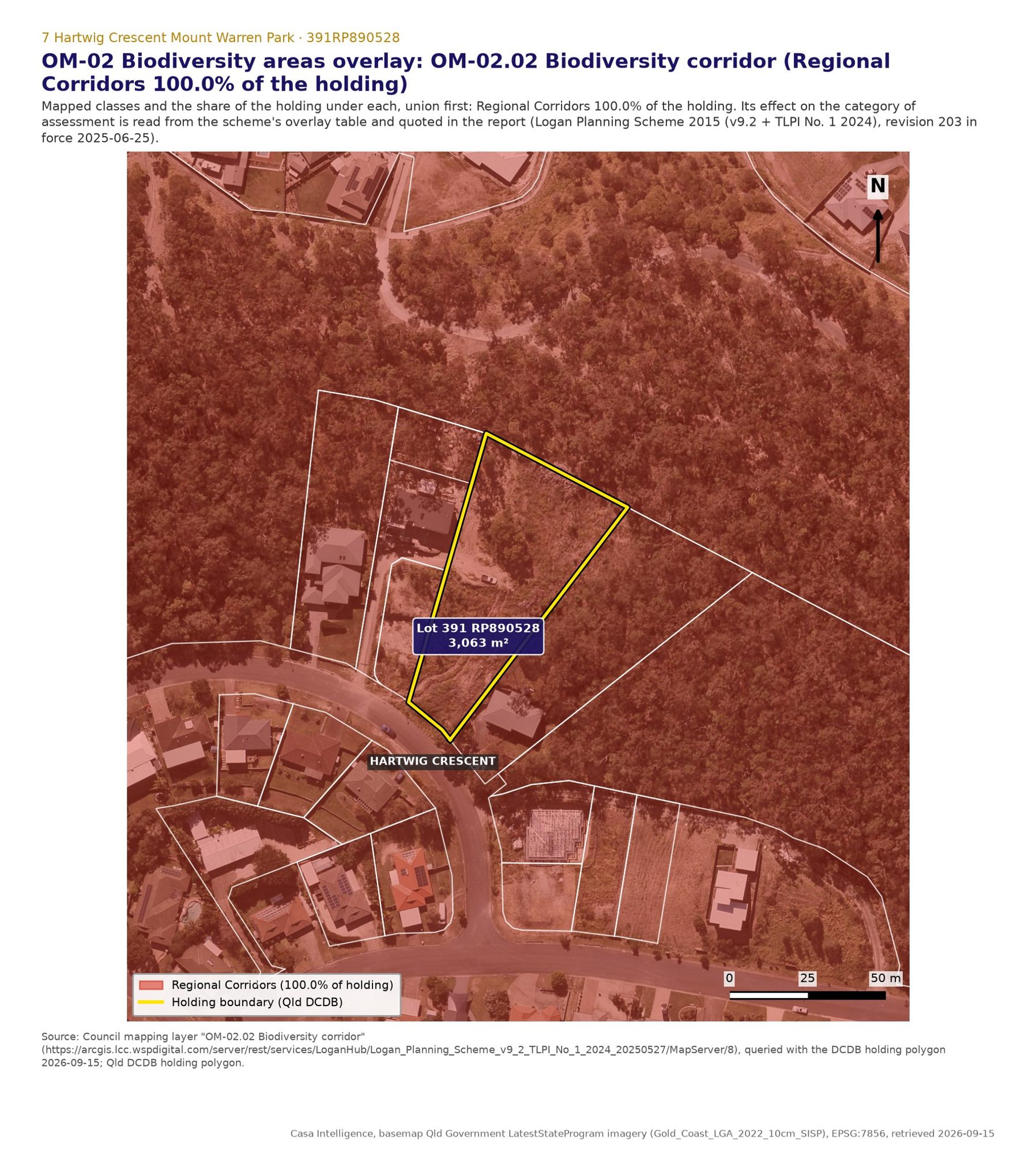
Council mapping layer "OM-02.02 Biodiversity corridor" (https://arcgis.lcc.wspdigital.com/server/rest/services/LoganHub/Logan_Planning_Scheme_v9_2_TLPI_No_1_2024_20250527/MapServer/8), queried with the DCDB holding polygon 2026-09-15; Qld DCDB holding polygon.
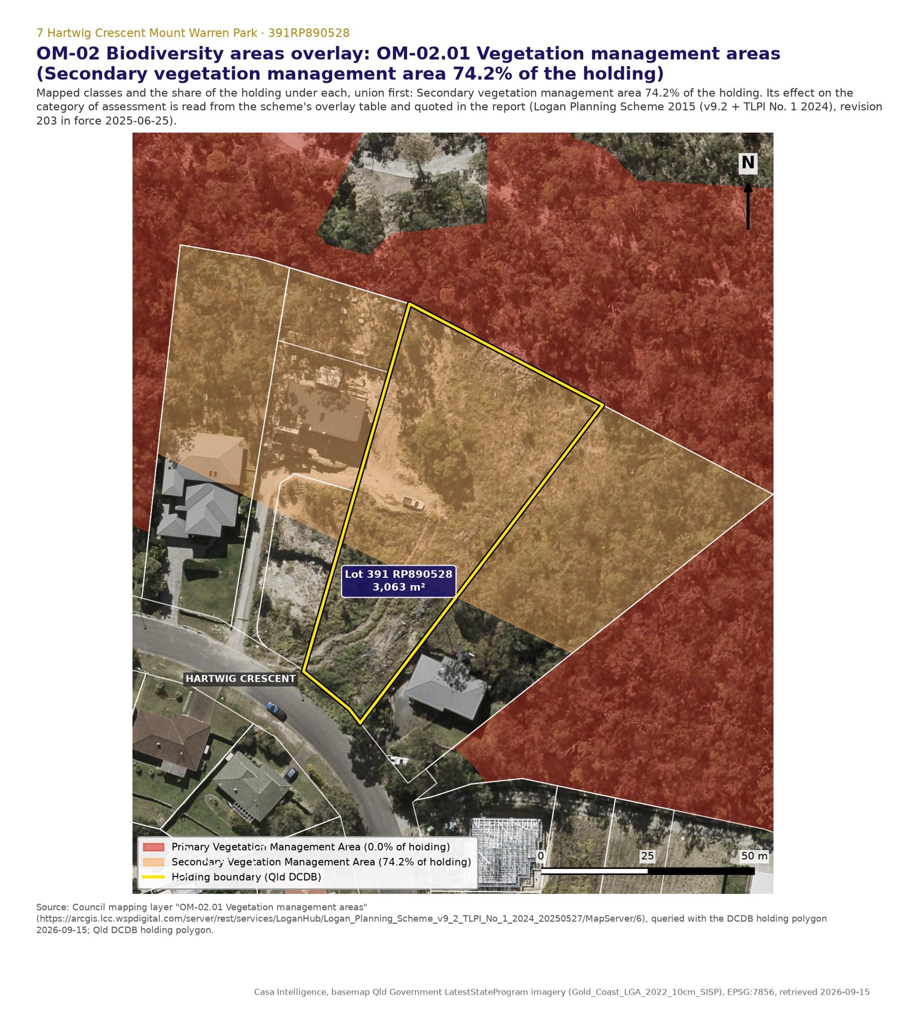
Council mapping layer "OM-02.01 Vegetation management areas" (https://arcgis.lcc.wspdigital.com/server/rest/services/LoganHub/Logan_Planning_Scheme_v9_2_TLPI_No_1_2024_20250527/MapServer/6), queried with the DCDB holding polygon 2026-09-15; Qld DCDB holding polygon.
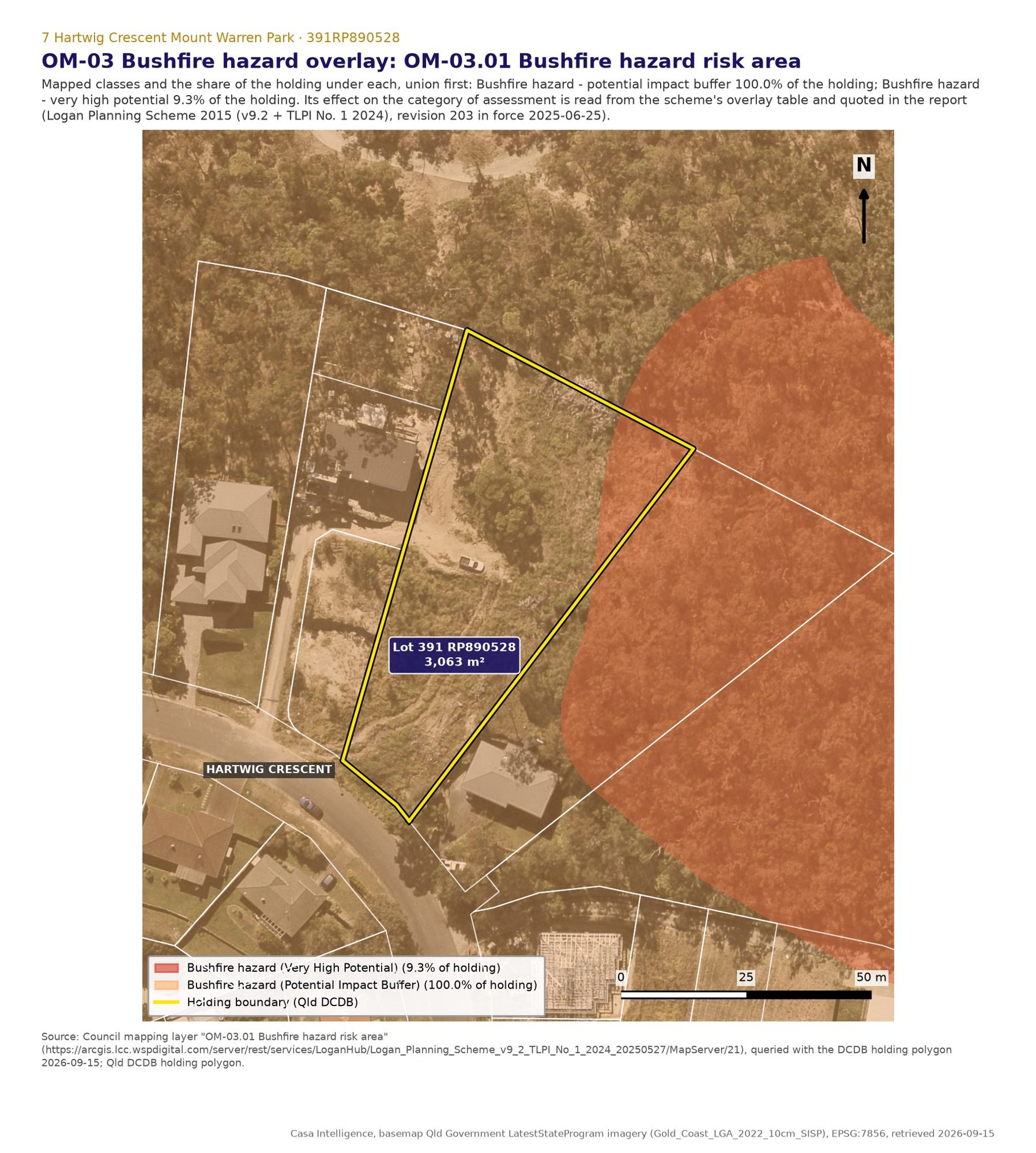
Council mapping layer "OM-03.01 Bushfire hazard risk area" (https://arcgis.lcc.wspdigital.com/server/rest/services/LoganHub/Logan_Planning_Scheme_v9_2_TLPI_No_1_2024_20250527/MapServer/21), queried with the DCDB holding polygon 2026-09-15; Qld DCDB holding polygon.
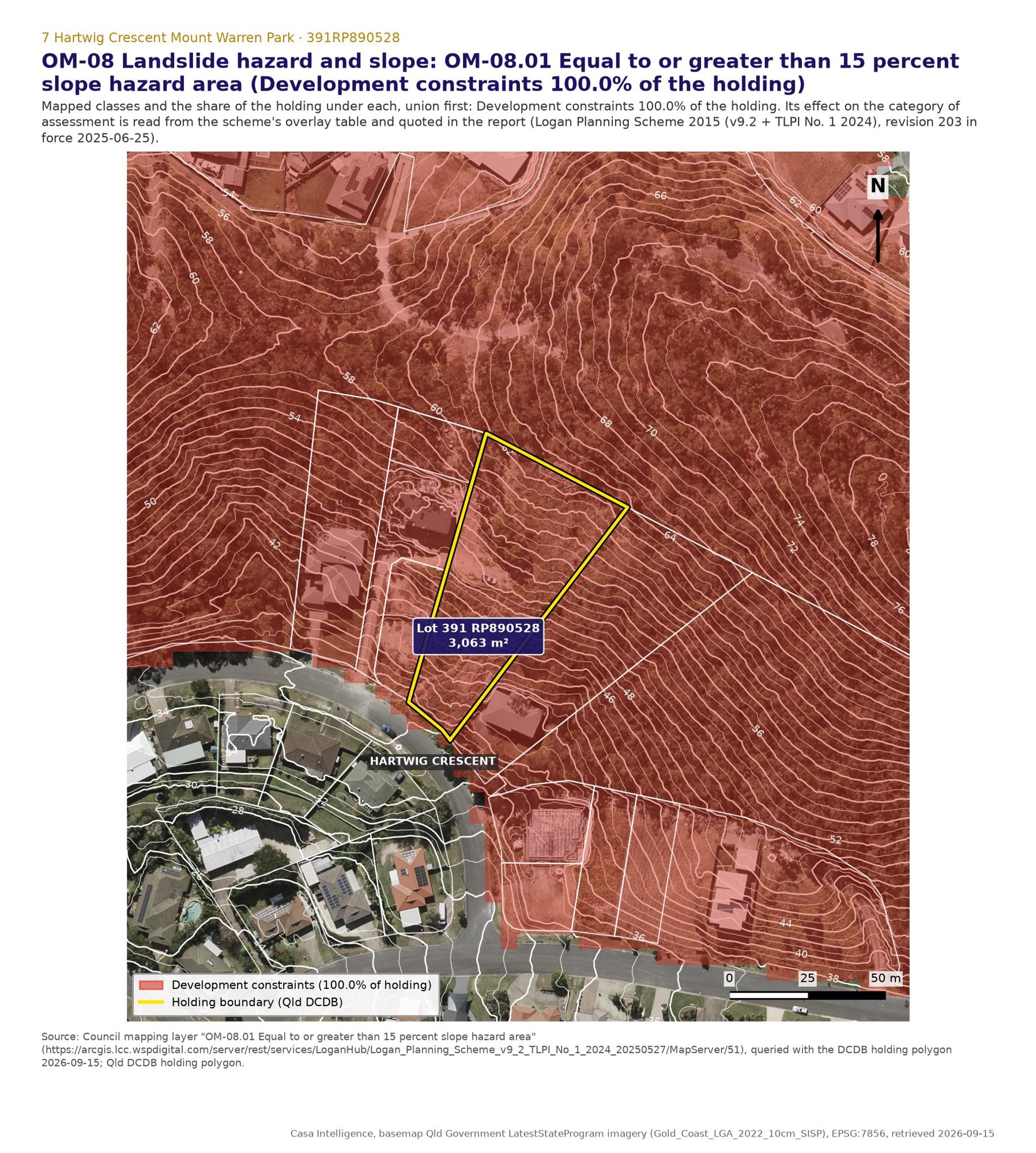
Council mapping layer "OM-08.01 Equal to or greater than 15 percent slope hazard area" (https://arcgis.lcc.wspdigital.com/server/rest/services/LoganHub/Logan_Planning_Scheme_v9_2_TLPI_No_1_2024_20250527/MapServer/51), queried with the DCDB holding polygon 2026-09-15; Qld DCDB holding polygon.
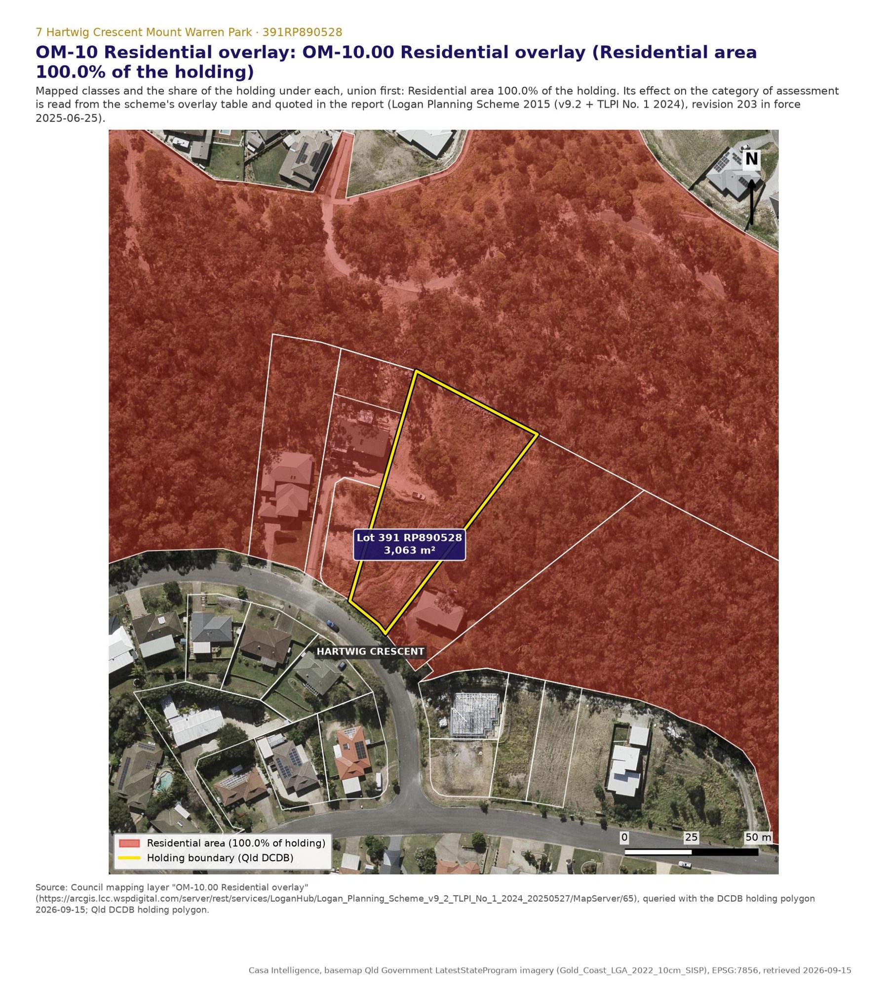
Council mapping layer "OM-10.00 Residential overlay" (https://arcgis.lcc.wspdigital.com/server/rest/services/LoganHub/Logan_Planning_Scheme_v9_2_TLPI_No_1_2024_20250527/MapServer/65), queried with the DCDB holding polygon 2026-09-15; Qld DCDB holding polygon.
Ground, levels and construction
The governing hazards: slope and bushfire
No flood layer touches this land: Council's flood assessment area came back clear, and no State storm tide, erosion prone or coastal management mapping applies. The hazards that govern here are bushfire and slope, and they are governed together because the same approved documents deal with both.
Slope. The ground model is the State 1 m LiDAR. The lot runs from RL 36.05 m AHD at the road to RL 63.77 m AHD at the rear, 27.72 m of fall over about 92.5 m of depth. Council maps the whole lot in the Equal to or greater than 15 per cent slope hazard area on OM-08.01, and the 1 m ground model measures a mean slope of 32.08% with 94% of the lot at 15% or steeper. On the same model 97% of it is at or over the 12% gradient the code's geotechnical acceptable outcome names, including 99% of the ground under the front test fit and 96% under the middle one (mean 29.5% at the front and 28.9% in the middle). Under the front test fit the ground sits between RL 41.63 and RL 44.36 m AHD, 2.73 m of fall at a mean 29.5%; in the middle envelope it is RL 45.09 to RL 48.86, 3.77 m of fall. A level platform at the mean level would need roughly 1.4 m of cut or fill at the edges at the front and about 1.9 m in the middle, which is why a split level house that steps with the slope is the design that keeps the earthworks in the accepted category: filling and excavation stays accepted subject to requirements while retaining walls stay under 1.5 m (or 3 m benched), and any wall over 1.0 m must be designed to the infrastructure policy standard.
Bushfire. The whole lot is inside the potential impact buffer and 9.3% of it, 284 m2 at the eastern tip, is mapped very high potential. The lot is a designated bushfire prone area, so construction to AS3959-2018 comes through the building approval whatever the planning category. Council's approved bushfire management plan for COM/6/2022 goes further and binds the land: a 9 m no dwelling zone across the north and a 12 m no dwelling zone down the east, a maximum construction level of BAL-29 across the envelopes and a minimum of BAL-12.5 for the front envelope. Those zones are drawn and subtracted in section 7.
What Council's practice nearby shows. At 1 Hartwig Crescent, about 103 m away, Council recorded that the proposal did not comply with the setback and geotechnical acceptable outcomes, satisfied itself under the matching performance outcomes, and conditioned the private certifier accordingly (MCUR/112/2024, decided 2025-05-27). At 9 Hartwig Crescent next door the officer accepted a slope stability assessment under the geotechnical outcome and a reduced road setback (MCUR/45/2024, decided 2025-04-16). In the decisions read for this report, slope is not what stops a house in this street; it is what prices and conditions it.
Pathway 1
Your plan, tested: the constraints subtracted and the house placed
This is the answer to what you asked for: every mapped constraint subtracted from the parcel, the residual envelope measured, and the house placed inside it and drawn to scale.
Subtracted, in order. Boundary setbacks first: 6 m to the road boundary and 1.5 m to the side and rear boundaries, which leaves a setback envelope of 2,619.5 m2. Then the exclusions that the approved permit puts on this land: vegetation covenants D and F over the rear (25.3% of the lot, no buildings, batters or services once registered), the bushfire management plan no dwelling zones across the north and down the east, and the approved access and services easements along the eastern boundary (8.0% of the lot as reconstructed on the cadastre, 8.7% using the areas printed on the approved plan). Those exclusions cover 1,473.6 m2 of the lot, 1,213.4 m2 of it inside the setback envelope; taking that out leaves a residual buildable envelope of 1,406.1 m2, so 1,654.8 m2 of the 3,060.85 m2 parcel is excluded in all. Of that residual, 715.9 m2 lies inside an approved development envelope: 376.0 m2 at the front and 339.9 m2 in the middle. The remaining 690.2 m2 is physically buildable but sits outside the approved envelopes, and that is where the corridor bites.
Not subtracted, and why. The biodiversity corridor (100%), the secondary vegetation management area (74.2%) and the steep slope area (100%) are not exclusion zones in the physical sense. They do not say a building may not stand there; they say what must be proved, and in the corridor's case they decide which category of assessment a house falls into. Treating them as hatched no build areas would leave no lot at all, which is not what the scheme does.
The house, placed. The front envelope gives a buildable zone of 376.0 m2 once the boundary setbacks are taken out (neither the approved easement nor a bushfire no dwelling zone falls inside this envelope), and the largest clean rectangle in it measures 13.5 by 20.0 m (270.0 m2). A 13.5 by 9 m two storey module (the 14 by 9 m test module trimmed to the width of that rectangle), 121.5 m2 of footprint, was placed inside it on the flattest ground available: 12.9 m to Hartwig Crescent against the 6 m acceptable solution, west 2.9 m, east 6.3 m, rear 65.7 m against 1.5 m, site cover 4.0% of the 3,061 m2 lot; 18% of the future Lot 6 (669 m2) against the 50% maximum, and none of the footprint inside the vegetation management area. The module is an assumption for testing, not a design.
The acceptable outcome answer, and what rests on a performance outcome. In that position the measurable acceptable outcomes are met, so the use needs no development application provided the rest of section 9.3.2 is satisfied in the detail: a site specific geotechnical report certified by an engineer, with cut and fill kept to 40 m3 or less and any undercroft screened and no more than 3 m high at its perimeter (the geotechnical acceptable outcome AO27 sets all three; a level platform at the mean ground level under this 121.5 m2 footprint on 2.73 m of fall would move about 77 m3 of cut and fill, measured on the 1 m ground model without batters, so a house that does not step with the slope misses AO27 and becomes code assessable on that point, exactly as Council recorded at 1 Hartwig Crescent under MCUR/112/2024), retaining designed to the infrastructure policy where walls exceed 1.0 m, construction to the approved bushfire plan, and no clearing of native trees beyond what the approval and the clearing tables allow. What rests on a performance outcome, here, is nothing about the corridor, because the location inside an approved envelope answers it. Move the house out of the envelope, or clear native vegetation beyond the envelope, and the performance outcome route opens up instead: "PO21 A Dual occupancy (auxiliary unit) or Dwelling house in: a Biodiversity corridor identified on Biodiversity areas overlay map OM-02.02 is designed and located to: provide for habitat links; facilitate safe wildlife movement; facilitate wildlife refuge; enhance habitat values; rehabilitate degraded areas with native vegetation;" proved by a detailed ecological assessment.
How three nearby approved applications handled this overlay. At 9 Hartwig Crescent, next door, Council accepted that the site size restricted where the house could go, that the vegetation would remain undisturbed and that there was no barrier to fauna movement, and approved (MCUR/45/2024, decided 2025-04-16). At 10 Jim Place, about 137 m away, the officer's reasons record that the house was in the mapped corridor and so did not comply with the acceptable outcome, then that it "will be located on a cleared lot, in an already urbanised and disturbed area. No clearing will be undertaken as part of the development with no worsening impacts to wildlife movement and refuge. Therefore, the proposed development complies with PO21" (MCUR/22/2023, decided 2023-11-21). On this very lot, Council's information request for COM/6/2022 asked for exactly the same thing, in these words: "Provide a detailed ecological assessment report prepared in accordance with Part 2 of Planning scheme policy 3 - Environmental management to demonstrate compliance with performance outcome PO1", and the approval followed on 2023-01-18. The pattern is consistent: the corridor is answered with an ecological assessment and a no clearing commitment, not avoided.
Note
The measured tier. Areas, setbacks, levels and grades in this section are measured on the State cadastre and the State 1 m ground model and drawn on the reconstructed approved plan. They are subject to survey, and the reconstruction is not the registered survey plan.
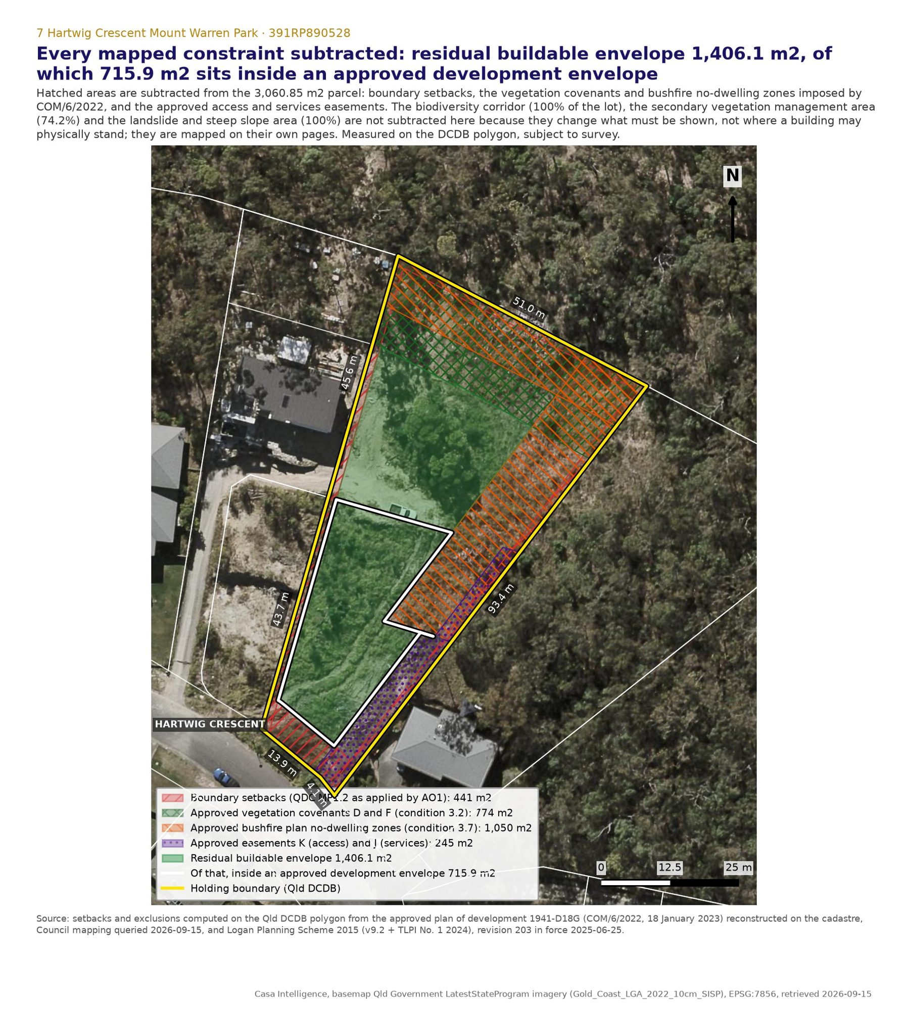
setbacks and exclusions computed on the Qld DCDB polygon from the approved plan of development 1941-D18G (COM/6/2022, 18 January 2023) reconstructed on the cadastre, Council mapping queried 2026-09-15, and Logan Planning Scheme 2015 (v9.2 + TLPI No. 1 2024), revision 203 in force 2025-06-25.
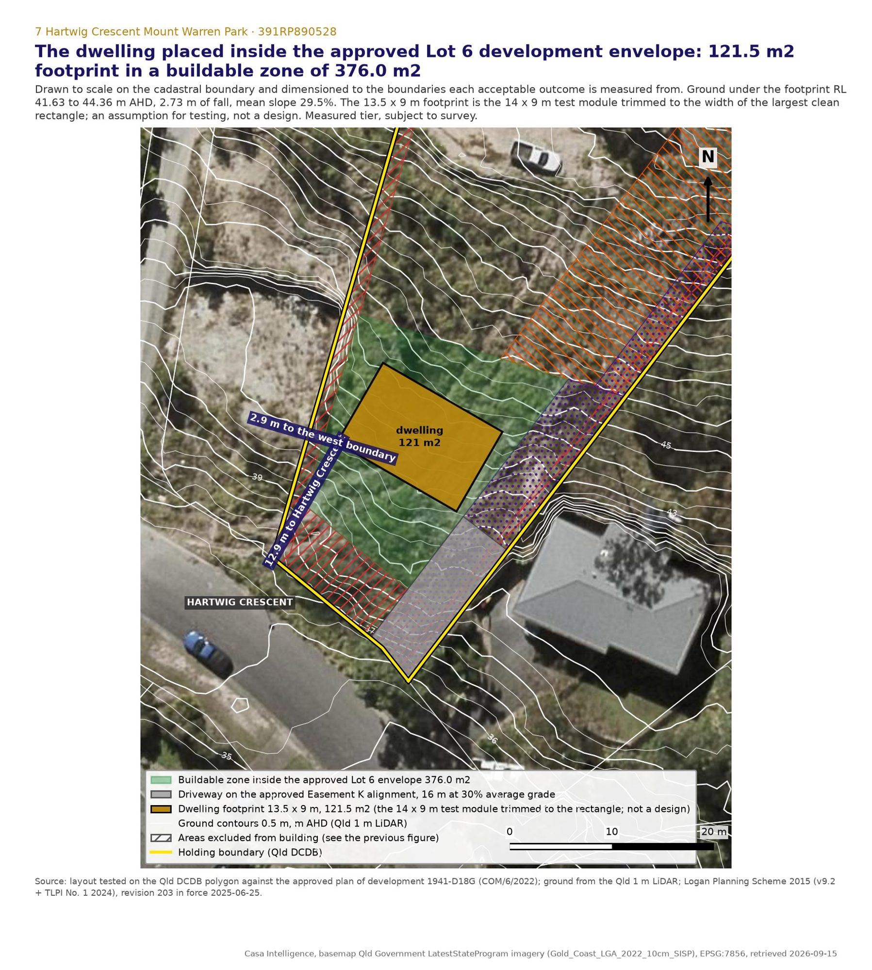
layout tested on the Qld DCDB polygon against the approved plan of development 1941-D18G (COM/6/2022); ground from the Qld 1 m LiDAR; Logan Planning Scheme 2015 (v9.2 + TLPI No. 1 2024), revision 203 in force 2025-06-25.
Pathways 2 to 5
The other pathways, tested the same way
Pathway 2, the middle envelope. The buildable zone is 339.9 m2 and the test module fits untrimmed at 14 by 9 m, 126.0 m2, with 27.0 m to the road and west 2.0 m, east 12.7 m, rear 48.9 m, site cover 4.1% of the 3,061 m2 lot; 21% of the future Lot 5 (612 m2). The category is the same as pathway 1. The differences are physical: 3.77 m of fall under the footprint, 67% of the footprint inside the vegetation management area, a driveway of 32.7 m climbing from RL 35.88 to RL 45.21 m AHD, and the higher bushfire construction level. Retaining walls will pass 1.5 m unless the house steps with the slope, and if they do the earthworks themselves become code assessable. Council accepted slope stability reports on the same ground at 43 Lane Court (MCUR/255/2020, decided 2020-12-09) and at 13 Lan Place (MCUR/67/2021, decided 2021-05-05), where the officer recorded that a Form 15 had been submitted and the proposal complied with the matching performance outcome.
Pathway 3, a house anywhere else on the lot. There is 690.2 m2 of physically buildable ground outside the approved envelopes, at RL 50.77 to 59.34 m AHD and a mean slope of 29.6%. Because the corridor covers the whole lot, the acceptable outcome is not capable of being met there, and the use becomes code assessable limited to that subject matter. That is a real route, not a refusal: it is the route every neighbour has taken. It costs an application, an ecological assessment prepared to the environmental management policy, a geotechnical report, a bushfire assessment and Council's decision period, and it normally comes back conditioned on tree retention, rehabilitation planting and fauna friendly fencing. Clearing native vegetation inside the corridor is itself code assessable operational work unless it is the fuel reduction clearing the tables allow around an approved class 1 building (rules 15047, 15063).
Pathway 4, act on the approved subdivision. The reconfiguration approval creates Lot 6 at 669 m2, Lot 5 at 612 m2, Lot 3 at 725 m2 and Lot 4 at 1,055 m2 with the envelopes, covenants and easements already conditioned. Council approved a frontage of 7.1 m excluding Easement K for the front lot, against the 12.5 m minimum frontage the scheme sets for a normal lot in this precinct (Table 9.4.6.3.2, rule 15517; Council's decision notice recorded 15 m, the table's corner lot column, as the prescribed acceptable outcome), under performance outcome PO3 of the reconfiguring a lot code, so that judgement is already made and does not have to be re argued. The operational works approval OW/47/2024 (decided 2025-04-29) means an engineered driveway and retaining design for the access already exists. Two conditions of that package matter to timing: the works and the plan of survey both have to be finished inside the currency periods, and access to the rear lots depends on an easement over 9A Hartwig Crescent, which the approval assumes is in the same ownership.
Pathway 5, a second dwelling. An auxiliary unit is accepted development subject to requirements under the same code, with a gross floor area limit of 100 m2 on the lot as it stands, falling to 70 m2 on a residential lot under 1,000 m2 such as the future Lot 5 (612 m2), as condition 6.3.2(f) of COM/6/2022 restates, and Council's condition confines auxiliary units to the future Lots 4 and 5 and only after the survey plan registers. No test fit for two dwellings was drawn in this study, so this report states no yield for it.
| Pathway | What it is | Where it lands | Category of assessment |
|---|---|---|---|
| S1 | New dwelling inside the approved Lot 6 development envelope (front of the lot), accepted-development route | Open, on conditions | Accepted development (subject to requirements) under Table 5.10.10.1 against 9.3.2, if every acceptable outcome is met and Council confirms the envelope approval is relied on before the plan of survey is registered; building approval, bushfire rated construction and any operational work for earthworks still required |
| S2 | New dwelling inside the approved Lot 5 development envelope (middle of the lot) | Open, on conditions | as S1 (accepted development subject to requirements) but on ground averaging 28.9% with a longer, steeper driveway; the retaining and geotechnical conditions are heavier |
| S3 | New dwelling outside the approved envelopes (anywhere else on the lot) | Open, on conditions | Code assessable change of use (5.3.3(2)): AO21 cannot be met because the Biodiversity corridor covers 100% of the lot; assessed under PO21 (detailed ecological assessment per planning scheme policy 3 Part 2), PO20 where native trees are cleared in the VMA, AO27 geotechnical report, AO16 retaining; vegetation clearing operational work code assessable inside the corridor (Table 5.10.2.1.1) |
| S4 | Act on the approved subdivision COM/6/2022 (4 lots with envelopes) and build on the new lots | Open now | Development permits in effect: reconfiguration currency 4 years to 18 Jan 2027; change of use envelopes 6 years to 18 Jan 2029; OW/47/2024 2 years to 29 Apr 2027 |
| S5 | Dwelling house plus a Dual occupancy (auxiliary unit) on the lot as it stands | Not tested in this study | Table 5.5.5.1: Dual occupancy accepted development (subject to requirements) against 9.3.2; same overlay AOs as a dwelling house; COM/6/2022 condition 6.3.3 enables auxiliary units only on Lots 4 and 5 and 6.4 only after the survey plan registers |
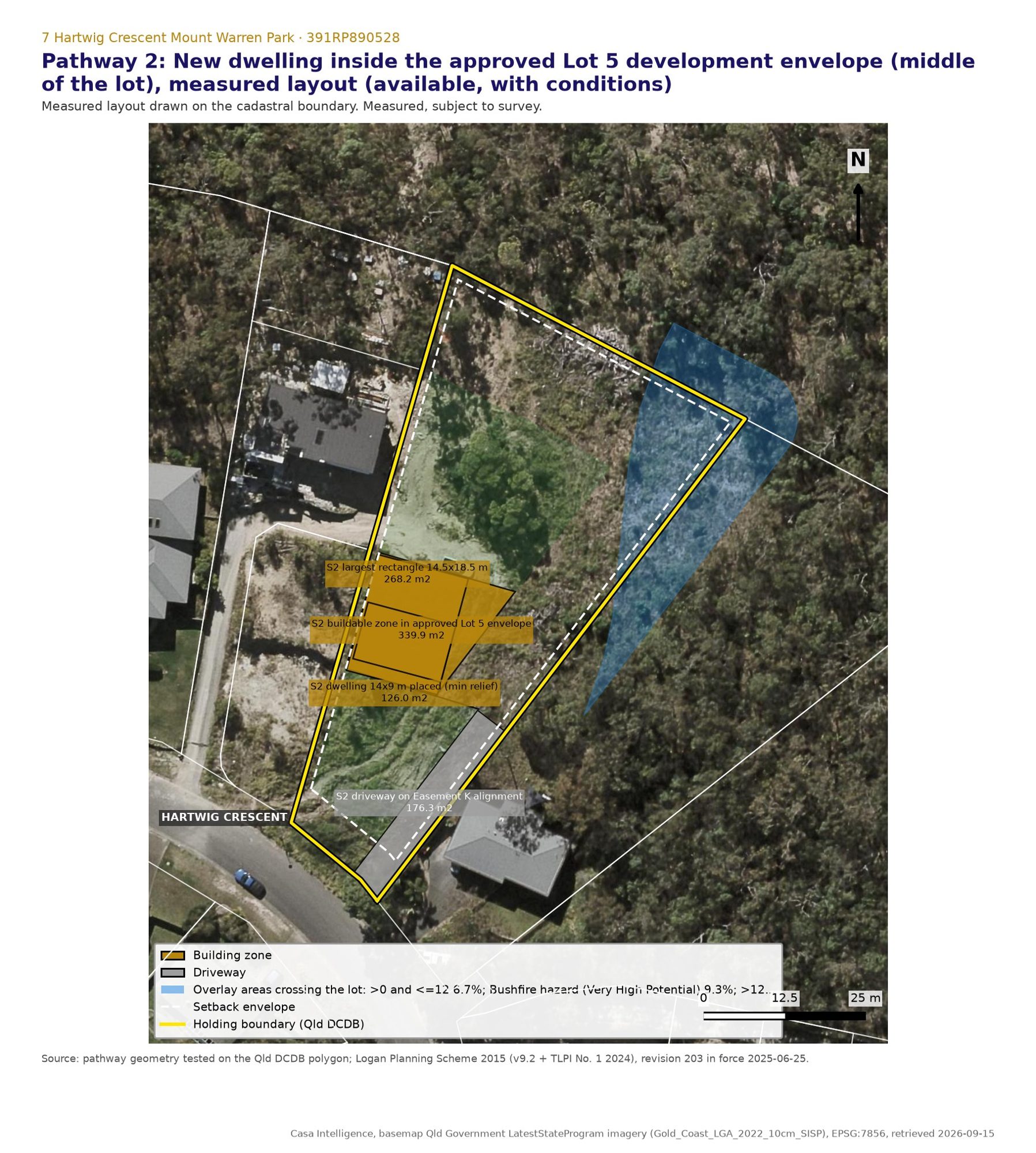
pathway geometry tested on the Qld DCDB polygon; Logan Planning Scheme 2015 (v9.2 + TLPI No. 1 2024), revision 203 in force 2025-06-25.
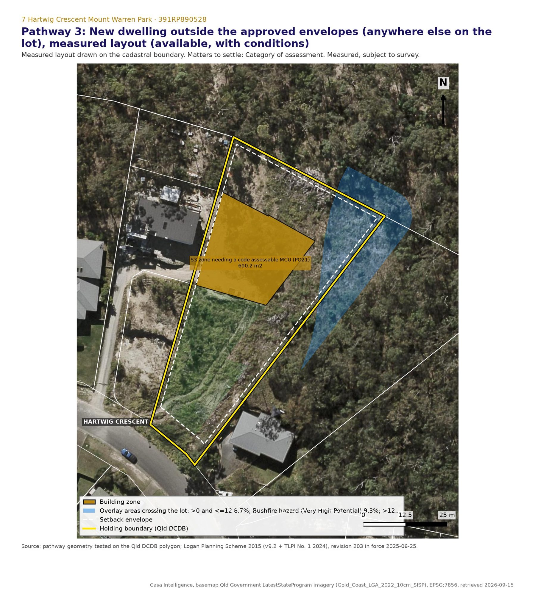
pathway geometry tested on the Qld DCDB polygon; Logan Planning Scheme 2015 (v9.2 + TLPI No. 1 2024), revision 203 in force 2025-06-25.
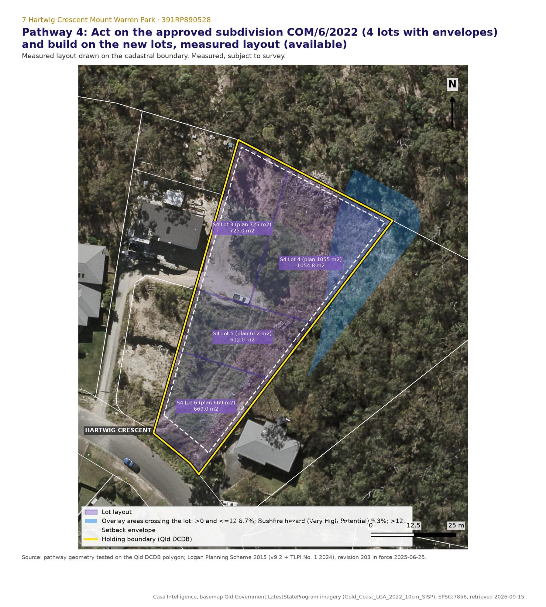
pathway geometry tested on the Qld DCDB polygon; Logan Planning Scheme 2015 (v9.2 + TLPI No. 1 2024), revision 203 in force 2025-06-25.
Frontage, easement and grade
Getting in and out: access and driveway
The lot has 17.99 m of frontage to Hartwig Crescent and no formed crossover on the 2022 imagery: the kerb sits below a steep cut batter. The code's access acceptable outcome asks only that development is connected to a constructed road and kept clear of the trunk infrastructure networks, which this lot satisfies. The working constraint is not width but grade.
The approved access is Easement K, 5.5 m access wide along the eastern boundary, and the operational works approval carries the engineered driveway and retaining walls for it. Measured on the 1 m ground model along that alignment, a driveway to the front envelope runs 16.0 m from RL 35.88 to RL 40.75 m AHD, an average grade of 30.4%, with the steepest 5 m at 52.4%. To the middle envelope it is 32.7 m at 28.5% average. Those are raw ground grades, not the designed profile: the approved engineering drawings under OW/47/2024 cut and retain that alignment, which is exactly why an operational works approval was taken out. Any driveway built to the raw ground would be unusable, and any design has to be measured against the driveway standard in the infrastructure policy and the transport code, which we have not quoted to a number here.
Council's practice on access in this street is visible in the approvals: the front lot was approved with a frontage of 7.1 m excluding Easement K, against the 12.5 m minimum frontage for a normal lot in this precinct (Table 9.4.6.3.2; Council's notice quoted 15 m, the corner lot column), under performance outcome PO3 of the reconfiguring a lot code, the neighbour's retaining walls for a driveway were approved as a change of use in their own right (MCUR/258/2020, decided 2020-11-19), and the works approval for this land was granted on 2025-04-29. Two car spaces per dwelling are conditioned by COM/6/2022.
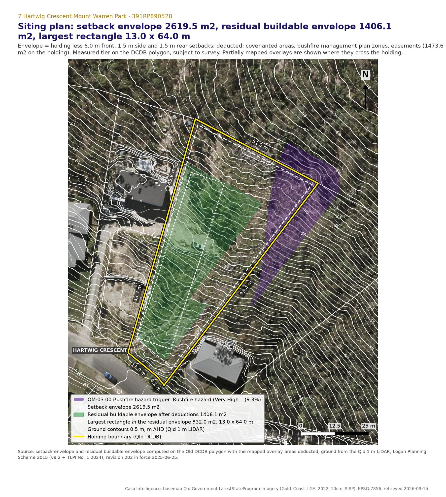
setback envelope and residual buildable envelope computed on the Qld DCDB polygon with the mapped overlay areas deducted; ground from the Qld 1 m LiDAR; Logan Planning Scheme 2015 (v9.2 + TLPI No. 1 2024), revision 203 in force 2025-06-25.
Practice
What Council has decided nearby, and on this land
Council's own decisions are the tie breaker on every judgement call in this report, so they are cited by number and read from Council's documents rather than the register summary. Within 2 km of this lot, 20 nearby applications on houses and subdivisions on the same overlays were read; 19 of them have been decided and one, MCUR/83/2025 at 2 Shae Place, is still undecided. Not one refusal of a house appears in the 300 register records the 2 km query returned, which is the limit the query was capped at, so the register was not read to its end. The pattern is uniform: a house on these overlays is lodged as a code assessable change of use described as a dwelling house with overlays, supported by an ecological assessment, a slope stability or geotechnical report and bushfire construction, and it is approved with conditions.
This lot's own history runs to 7 register records, five of which matter here. A four lot subdivision was approved in 2015 (RL/44/2015) and not acted on, and the operational works for it were approved the same year (OW/253/2015 and OW/295/2015). A house was approved in 2012 (MCUC/278/2011) and never built. An earlier two lot reconfiguration lapsed (RL/24/2011). The live approvals are COM/6/2022, decided 2023-01-18, which is the combined reconfiguration and the change of use that created the four development envelope areas, and OW/47/2024, decided 2025-04-29, the operational works that go with it.
| Application | Address | Distance | Proposal | Outcome | Decided |
|---|---|---|---|---|---|
| COM/6/2022 | 7 Hartwig Crescent Mount Warren Park | 0 m | Combined Application – Reconfiguring A Lot - 2 Lots Into 4 Additional Lots | Approved, read from the decision notice | 2023-01-18 |
| OW/47/2024 | 7 Hartwig Crescent Mount Warren Park | 0 m | Operational Work Relating To Com/6/2022 | Approved, read from the decision notice | 2025-04-29 |
| MCUR/45/2024 | 9 Hartwig Crescent Mount Warren Park | 35 m | Material Change Of Use - Residential - Dwelling House (Reduced Road Boundary C | Approved, read from the decision notice | 2025-04-16 |
| MCUR/258/2020 | 9A Hartwig Crescent Mount Warren Park | 35 m | Material Change Of Use - Dwelling House (Retaining Wall) | Approved, read from the decision notice | 2020-11-19 |
| MCUR/22/2023 | 10 Jim Place Mount Warren Park | 137 m | Material Change Of Use – Dwelling House (Overlays) | Approved, read from the decision notice | 2023-11-21 |
| MCUR/306/2021 | 12 Jim Place Mount Warren Park | 125 m | Material Change Of Use - Dwelling House (Reduced Road Boundary | Approved, read from the decision notice | 2022-01-28 |
| MCUR/411/2021 | 8 Jim Place Mount Warren Park | 156 m | Material Change Of Use Code - Residential - Dwelling House (Reduced Road Bound | Approved, read from the decision notice | 2022-02-09 |
| MCUR/67/2021 | 13 Lan Place Mount Warren Park | 210 m | Material Change Of Use Code - Dwelling House | Approved, read from the decision notice | 2021-05-05 |
| MCUR/255/2020 | 43 Lane Court Mount Warren Park | 169 m | Material Change Of Use - Dwelling House | Approved, read from the decision notice | 2020-12-09 |
| MCUR/112/2024 | 1 Hartwig Crescent Mount Warren Park | 103 m | Material Change Of Use - Dwelling House (Reduced Road Boundary | Approved, read from the decision notice | 2025-05-27 |
| MCUR/129/2022 | 39 Trevina Crescent Mount Warren Park | 97 m | Material Change Of Use Code - Residential - Dwelling House (Build Outside Enve | Approved, read from the decision notice | 2022-06-27 |
| MCUR/397/2021 | 34 Lane Court Mount Warren Park | 212 m | Material Change Of Use - Dwelling House (Overlays) | Approved, read from the decision notice | 2022-02-12 |
Next steps
What to do next, in order of leverage
1. Settle the one open question with Council in writing before anything is designed: whether a house built inside an approved envelope on the parent lot, before the plan of survey is registered, is treated as being inside a development envelope area approved by a development approval. The conditions tie only the auxiliary unit to registration, and the answer decides whether you are on pathway 1 or pathway 3. A planning enquiry or a pre lodgement meeting produces that answer and costs nothing but time.
2. Get the approved documents that are referred to but not published: the bushfire management plan, the ecological assessment and the geotechnical reports named in the approval. Council's own condition says a copy is available. They tell you the construction level, the planting obligations and the footing design before you commission anything new.
3. Order a title search and a plan lodgement check. The cadastre still shows the parent lot, so the easements and covenants Council has conditioned are approved but not yet on title, and nothing in this report can tell you what else the title carries.
4. Commission the survey. A contour and detail survey with the boundaries marked converts every measured number in this report from mapping to survey, and it is the base every later drawing needs.
5. Commission the site specific geotechnical report to the infrastructure policy standard with the engineer's certification. It is required by the code on any route, it drives the footing and retaining design, and it is the document Council's officers have accepted from every neighbour.
6. Decide on timing against the currency periods. If the subdivision is wanted, the plan of survey has to be registered by 18 Jan 2027 and the works finished by 29 Apr 2027. If only a house is wanted, the envelope approval runs to 18 January 2029.
7. Then design to the envelope, not to the block: a split level house that steps with the slope, retaining kept under the accepted thresholds, and the driveway built on the approved engineering alignment.
Risk register
What could change this answer
Every number in this report was read or measured on the day of writing. These are the things that would move it, what each would do, and how each is closed out.
| Risk | Likelihood and basis | Effect if it happens | How it is closed |
|---|---|---|---|
| Council treats the approved envelopes as available only once the plan of survey is registered | Open. The approval does not say either way; conditions 6.2 and 6.4 tie only the auxiliary unit to registration | Pathway 1 and 2 become pathway 3: a code assessable application with an ecological assessment, which neighbours have obtained without refusal | Written confirmation from Council, or register the plan of survey first |
| The reconfiguration approval lapses before the plan of survey is registered | Dated: as at 15 September 2026, about 4 months (reconfiguration, to 18 January 2027, 125 days) and about 7 months (operational works, to 29 April 2027, 226 days) remain | The envelopes, the approved frontage relaxation and the works approval fall away and the whole package has to be re applied for | Register inside the currency period, or apply to extend it before it expires |
| The geotechnical report requires deeper footings, benching or larger retaining than assumed | Likely in some degree. Mean slope 32%, 94% of the lot at 15% or steeper, 2.73 m of fall under the front footprint | Cost and, if walls pass the thresholds, an operational works approval for the earthworks | Commission the report early and design the house to step with the slope |
| The title carries easements, covenants or other encumbrances not visible in mapping | Unknown. No title search was done for this report and the cadastre shows no easement on the parent lot | A building envelope or covenant on title could move or shrink the buildable area | Title search and a plan lodgement check |
| The bushfire management plan sets a construction level or a no dwelling line different from what Council's notice records | The plan is named in the approval but not published; its terms are known only as Council quotes them | The buildable zones shown here (715.9 m2 inside the envelopes) could move | Obtain the approved plan from Council or the owner |
| Setbacks assumed from the Queensland Development Code turn out to differ | The 6 m road boundary figure is taken from Council's own delegated report on the neighbouring approval; the 1.5 m side and rear figure is the standard acceptable solution and was not read from the source document for this report | A different setback changes the drawn position of the house, not the category of assessment | Read the current edition of the code before the design is fixed |
| The house is placed outside an approved envelope by choice | A design decision, not a risk imposed by the land | Code assessable change of use, ecological assessment, Council decision period and conditions | Keep the footprint inside the approved envelope, or budget for the application |
Honesty layer
What this report does not cover
- Table 9.4.6.3.2 read today (revision 203) sets a 12.5 m minimum frontage for a normal lot and 15 m only for a corner lot; Council's COM/6/2022 decision notice (18 Jan 2023) recorded 15 m as the prescribed acceptable outcome. The revision in force at the decision date was not read, so whether the table then read differently or Council quoted the corner lot column is unresolved; it changes nothing, the 7.1 m frontage is approved under PO3. Resolved by: read the scheme revision in force on 18 Jan 2023, or Council's delegated report.
- The road boundary and the side and rear clearances are read from QDC MP 1.2 (11 March 2010), held verbatim: A1(a)(i) sets a 6 m minimum road setback, and A2(a)(i) sets 1.5 m to a side or rear boundary for wall parts up to 4.5 m high, with 2 m under A2(a)(ii) for a wall part above that height. Council's delegated report at 9 Hartwig Crescent calls the 6 m the prescribed minimum as per Acceptable Solution 1 of QDC MP 1.2. The State's own publication page did not answer an automated request on the day of this report, so the text quoted here is Casa's held copy of the 11 March 2010 edition rather than a fresh download.
- Bushfire Management Plan 001.03.22 rev 2 (5 Aug 2022), Ecological Assessment (19 Apr 2022) and geotechnical reports (Rhys French 8 Oct 2021; Austral-Asia 13 Jun 2016; Rhys French cut stability advice 2 Apr 2024) are approved or referenced documents not published on Council's portal; their recommendations are known only as quoted by Council. Resolved by: obtain from Council (condition 3.9 says a copy is available) or the owner.
- COM/6/2022 delegated report not among the portal documents (decision notice refers to it). Resolved by: request from Council.
- Title not searched: registration status of the survey plan, Easement K/J and covenants D/F unknown; DCDB still shows Lot 391. Resolved by: title search and Titles Registry plan lodgement check.
- MCUC/278/2011 (house on overlays, 2012) documents are .doc files with no extractable text. Resolved by: convert or request; the approval has lapsed in any case.
- House numbers layer query error in the sweep (unchecked). Resolved by: immaterial: addresses read from Council decision notices.
- Driveway gradient and dwelling parking rate rows of 9.4.7 read only by pattern; verify wording before quoting a number. Resolved by: read Table 9.4.7.3.x rows in the scenarios step.
- TLPI No. 1/2024 subject not read; it is incorporated in revision 203 whose LDR and dwelling house tables were read. Resolved by: read the TLPI text to confirm it does not touch this site. The Queensland Housing Code (whether Logan has adopted it in place of parts of the Queensland Development Code) was not checked for this report, and the Queensland Heritage Register was not queried separately; Council's heritage overlay, which came back clear, was relied on.
- Whether Council accepts a dwelling built inside an approved envelope on the unsubdivided parent lot as "within a development envelope area approved by a development approval" (9.3.2 AO20 to AO22) before the plan of survey is registered is not stated in the approval; conditions 6.2 and 6.4 tie only the auxiliary unit to registration. Resolved by: written confirmation from Council (pre-lodgement or planning enquiry) before relying on the accepted-development route.
- The title was not searched for this report. Easements, covenants, building envelopes and any other encumbrance registered on title are unknown until a title search is done, and any of them can change where a house may stand.
- No site inspection, no survey and no geotechnical, ecological or bushfire investigation was carried out for this report. Boundaries are the State cadastre, levels and slopes are the State 1 m ground model, and canopy and the absence of a crossover are read from 2022 aerial imagery.
- The approved plan of development was reconstructed on the cadastre from the printed dimensions and areas on the approved plan, because the survey plan is not registered. The reconstructed lot areas match the printed areas for all four lots and the reconstructed middle development envelope (550.7 m2 against 548 m2 printed) is within 0.5% of its printed area, but the reconstructed front (Lot 6) development envelope is 485.7 m2 against the 465 m2 printed on the approved plan, 4.5% larger; the two rear envelopes are approximate. Every buildable area taken from the front envelope carries that tolerance. It is not a survey plan and it is not the approved plan.
- The dwelling drawn is an assumed module of 14 by 9 m over 2 storeys (trimmed to 13.5 by 9 m, 121.5 m2, where it is placed in the front envelope; 14 by 9 m, 126.0 m2, in the middle envelope), used to test whether a house of ordinary size fits the measured envelope. It is not a design and no design work is included in this report.
- Where the lot forms part of an estate subdivision, estate covenants commonly restrict dwelling form, materials, roof pitch, fencing and siting. Any such covenant must be read before design begins; none was available to this report.
Deterministic site plan
Site Analysis Plan
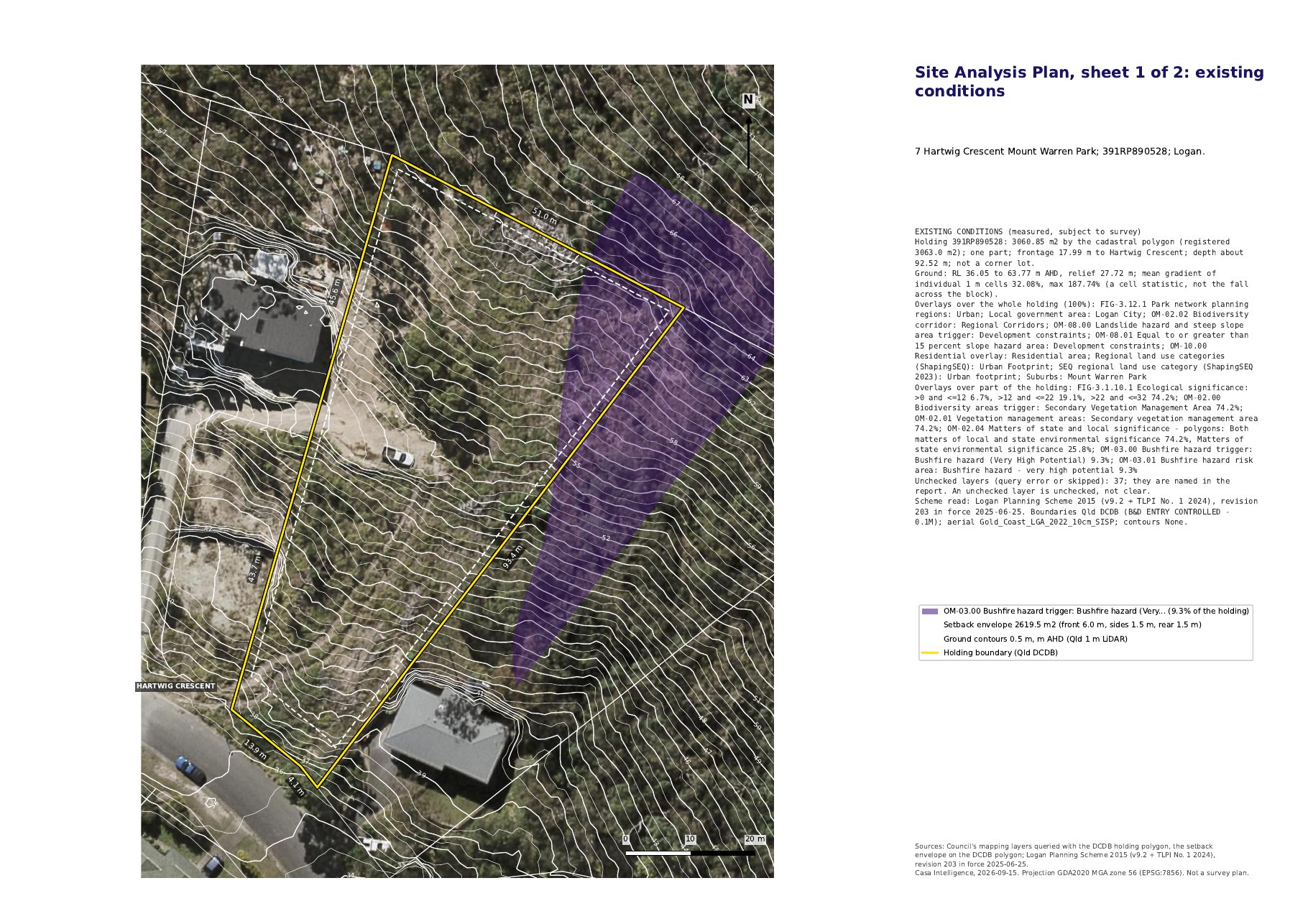
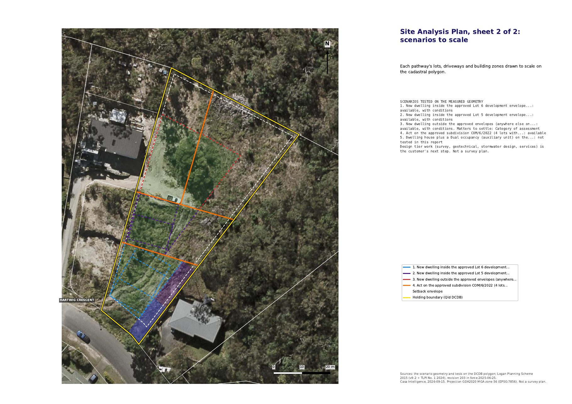
This is a real Casa Intelligence report, prepared on a real property using public planning and cadastral data. The property was selected from public listing and development-application records and we have no connection with its owner. Prepared 15 September 2026 against the planning scheme in force on that date.
Pre-delivery audit and planner pass recorded 15 September 2026. Site-constraint gate for the modelled scenario (dwelling_house): reject. If you are the owner of this property and would like this page removed, email hello@casaintelligence.com.au and it comes down within two business days, no questions asked.
This report is an assessment of record. It states what the cited primary sources say on the day they were read: the planning scheme in force for Logan City, the Council mapping services queried against the cadastral boundary, the State cadastre and elevation data, and Council's own decision notices, conditions and approved plans for the applications cited by number. It is general planning information, not planning or legal advice, and it is not a guarantee that any application will be approved or that any development is lawful. Categories of assessment can change with a scheme amendment or a temporary local planning instrument, and approvals expire. Casa Intelligence does not act as the planner of record for any application and has not been engaged to lodge, manage or certify one.