Preliminary planning report
Site Possibilities
166 Jesmond Road Indooroopilly QLD
What 166 Jesmond Road Indooroopilly QLD can be used for, and the pathway to it
- Report reference
- CI-20260915-IND
- Issued
- 2026-09-15
- Scheme in force
- Brisbane City Plan 2014, revision 272 in force 2026-06-14
- Prepared for
- Published as a sample
The answer
A duplex does not fit this block, and no layout can make it fit.
The scheme calls it a dual occupancy, and the acceptable outcome for one in this zone asks for 3,000 m2 of land and 40 m of street frontage. The lot is 1,057 m2 with 20.25 m of frontage to Jesmond Road. Two homes on this land are still possible, by a different route: the lot already holds a current Council approval to be split into two lots of 527 m2 each, and a house on each of those lots is accepted development provided it meets every acceptable outcome of the Dwelling house code. On the single lot as it stands today, one house plus a secondary dwelling of up to 80 m2 is accepted development on the same terms.
What the block cannot do is carry three or more dwellings: the zone code says in terms that multiple dwellings are not accommodated here. A duplex is not forbidden, but the only route to one is impact assessment with public notification, against a code whose own words put duplexes in this zone on larger sites, and we found no approval for a new duplex in this zone within about 1.2 km of this lot, or anywhere in our Brisbane register, since 2019. We would not put a client's money behind it while the two lot approval is sitting on the title.
The one fact that shapes everything is that approval. Council granted it on 2023-03-01 and changed it on 2026-03-06; the infrastructure charge of $15,498.37 was levied on the lot and is payable when Council approves the plan of reconfiguration; and the whole thing ends on 31 May 2027 unless the plan of subdivision is given to Council before then. That approval, with a house on each new lot built to every acceptable outcome of the Dwelling house code, is the most this land can hold. The two lots themselves were approved on a performance outcome of the Subdivision code for their width, so it is the houses, not the subdivision, that meet every acceptable outcome.
1,057 m2
Registered lot area
20.25 m
Frontage to Jesmond Road
3,000 m2
Duplex needs
2 lots
Already approved
Summary
You asked for a duplex on 166 Jesmond Road Indooroopilly QLD drawn to scale, with the frontage, setbacks, separation, open space, parking and access each proved against the scheme's own provisions, for what Council has approved nearby with a real infrastructure charge, for the pathway, and for the maximum that meets every acceptable outcome if a duplex does not fit. It does not fit. This report draws the duplex anyway, to scale, and shows that it meets every built form outcome we tested against the Dual occupancy code and fails the one about land area and frontage, which no design can cure; the outcomes that depend on a design (privacy and screening, the covered part of each open space, landscaping and deep planting, street facing windows, fences, the 150 m separation from any spray painting workshop and the swept path) were not tested. It then sets out the pathway that does work, priced from Council's own charge notices, and what Council has actually decided on the lots around this one.
- Address
- 166 Jesmond Road Indooroopilly QLD
- Lot / plan
- 30RP23615
- Local government
- Brisbane City Council
- Zone
- Low density residential zone
- Site area
- 1,057 m²
- Overlays
- Dwelling house character, Bushfire: Medium hazard area, Bushfire: High hazard buffer area, Transport air quality corridor B, Airport environs: BBS 3-8 km and PANS, Critical infrastructure and movement network planning area, Potential and actual acid sulfate soils, Land above 5 m and below 20 m AHD
The answer
The short answer, pathway by pathway
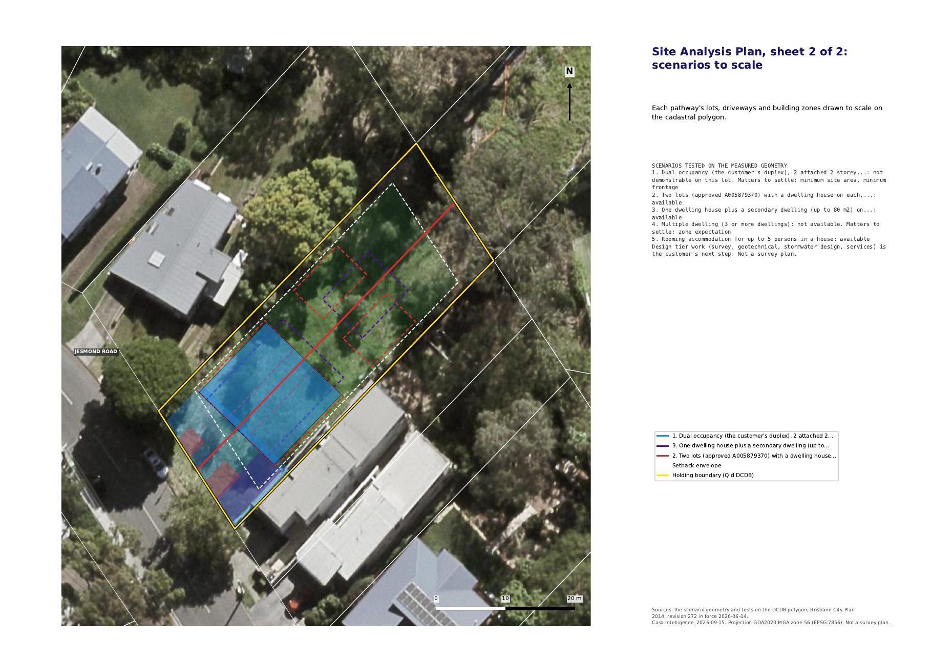
1. Your duplex (in the scheme's words a dual occupancy: 2 dwellings (whether attached or detached) on a single lot). Not demonstrable on this lot. There is no row for a dual occupancy in the table of assessment for the Low density residential zone, so the catch all row applies and the use is impact assessable, assessed against the whole planning scheme with public notification (Table 5.5.1, rule 16904). Inside that assessment, the Dual occupancy code's first acceptable outcome asks for 3,000 m2 and 40 m of frontage (Table 9.3.6.3.B, rule 15211). The lot is 1,057 m2 and 20.25 m. Every built form outcome we tested in that code (the fourteen listed in section 7) is met on the layout we drew; that one outcome is not, and cannot be. Privacy screening to the neighbouring house, the covered part of each open space and the vehicle swept path are design matters not tested.
2. Two lots, a house on each, optionally a secondary dwelling on each. Available, and already approved. The reconfiguration is a Development Permit Council granted on 2023-03-01 (A005879370), changed on 2026-03-06 (A006914652), for Lot 1 527 m2 frontage 10.086 m and Lot 2 527 m2 frontage 10.071 m. Each of those lots is above the 450 m2 standard lot size (rule 39070), so neither is a small lot, and a house on each is accepted development provided it meets every acceptable outcome of the Dwelling house code (Table 5.10.9, rule 13132). A secondary dwelling of up to 80 m2 within 20 m of the house may be added to either, still as one dwelling house use (rule 15276). The lot widths of about 10 m were approved on the performance outcome of the Subdivision code (PO1, Table 9.4.10.3.B, rule 39070), not its acceptable outcome; that approval is granted and current.
3. One house plus a secondary dwelling on the lot as it stands. Available. Two dwellings, two households, one title, no subdivision. Accepted development provided every acceptable outcome of the Dwelling house code is met (rule 5312 and rule 13132), with 1 car parking space for the dwelling house; 1 car parking space for any secondary dwelling on the same site. The test layout puts a 12.0 x 16 m house at 6.72 m from the frontage with 3.87 m side clearances and a 76 m2 secondary dwelling behind it.
4. Three or more dwellings (a multiple dwelling). Not available. The use is impact assessable (rule 16904) and the zone code says in terms: "Development maintains a low density character in which multiple dwellings are not accommodated." (rule 22118).
5. Rooming accommodation for up to five persons in a house. Available, as accepted development subject to requirements, where there is no more than one dwelling on the lot and the listed acceptable outcomes are met (Table 5.5.1, rule 16900). Listed here for completeness; it was not drawn.
| Pathway | Where it lands | Category of assessment | Outcomes not met |
|---|---|---|---|
| Dual occupancy (the customer's duplex), 2 attached 2 storey dwellings | Not demonstrable on this lot | Impact assessable (Table 5.5.1 rule 16904); Bushfire overlay code sections A and B, TAQC section B, the Airport environs overlay code (PANS-OPS, rule 7511) and the Road hierarchy, Streetscape hierarchy, Bicycle network and Community purposes network overlay codes are benchmarks within it; public notification required | minimum site area; minimum frontage |
| Two lots (approved A005879370) with a dwelling house on each, optional secondary dwelling on each | Available | Reconfiguration already approved (code assessment, currency to 31 May 2027); each house accepted development subject to the Dwelling house code AOs (Table 5.10.9 rule 13132), else code assessment; building approval and a BAL assessment (Table 1.7.1) still required | none for the houses: every Dwelling house code outcome tested is met. The approved reconfiguration itself relies on PO1 of the Subdivision code for average lot width and minimum rectangle (Table 9.4.10.3.B, rule 39070); it is approved and current |
| One dwelling house plus a secondary dwelling (up to 80 m2) on the single lot | Available | Accepted development subject to compliance with the Dwelling house code AOs (else code assessment); building approval and BAL assessment still required | none: every tested outcome is met |
| Multiple dwelling (3 or more dwellings) | Not available | Impact assessable (Table 5.5.1 rule 16904) | zone expectation |
| Rooming accommodation for up to 5 persons in a house | Available | Accepted development subject to requirements (Table 5.5.1 rule 16900: 5 persons or less, one dwelling on the lot, section A of the Rooming accommodation code and AO2, AO3, AO5 of the Dwelling house code) | not tested: listed for completeness; accepted development only where every listed acceptable outcome is met and there is no more than one dwelling on the lot |
Note
The duplex fails on land area and frontage by a wide margin: 3,000 m2 required against 1,057 m2 held, and 40 m of frontage required against 20.25 m held. There is no acceptable outcome, no variation and no overlay that changes those two numbers on this lot.
Scope and method
What we were asked, and how we answered it
Your words were: "Sample report for a dual occupancy (duplex) on this block: the most that meets every acceptable outcome, drawn to scale, with the frontage, setbacks, separation, open space, parking and access each proved against the scheme's own provisions, what council has approved nearby with any infrastructure charge quoted from a real decision notice, and the pathway. If a duplex does not fit, say so plainly and give the AO-compliant maximum."
We read the planning scheme in force today from Council's own electronic scheme: Brisbane City Plan 2014, revision 272, in force 2026-06-14, read on 2026-09-15. We took the lot boundary, area, frontage and neighbours from the State digital cadastre, the ground surface from the State 1 m laser survey, and every overlay from Council's live mapping queried with the lot boundary itself rather than with a point, so a partial overlay is measured as a share of the lot. We then read Council's own decision documents, information requests, conditions, stamped plans and infrastructure charges notices for this lot and for the applications around it, and we tested each pathway by drawing it on the measured boundary and checking every acceptable outcome against the scheme's own table. A two sheet site analysis plan at A3 accompanies this report.
What was not done, and is not claimed: no site inspection, no title search, no identification survey, no geotechnical investigation, no hydraulic or stormwater design and no bushfire attack level assessment. Boundaries, areas, levels and slopes in this report are measured from public records and are subject to survey. The layouts are test fits that prove what the rules allow; they are not a design and were not prepared by a designer. Section 13 lists every matter we could not resolve.
The land
The site
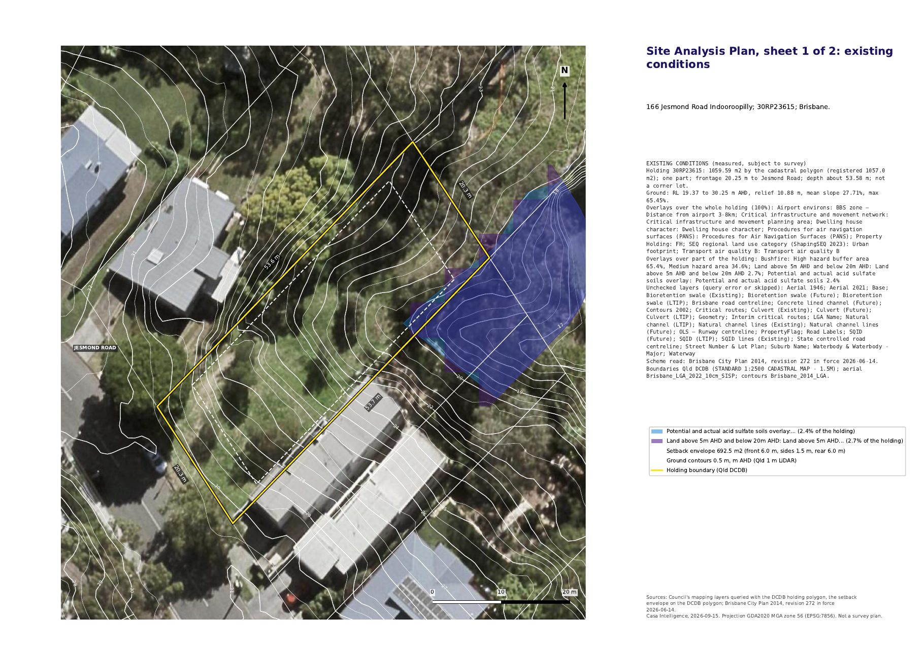
30RP23615 at 166 Jesmond Road Indooroopilly QLD is a single registered lot of 1,057 m2 (the State cadastral polygon measures 1,059.59 m2), with 20.25 m of frontage to Jesmond Road and a depth of about 53.58 m. It is not a corner lot. The State cadastre records no easement over it, and the title was not searched, so easements, covenants and other encumbrances registered on title remain unknown.
The land is vacant and grassed with trees over the rear half. It falls hard away from the street: RL 19.37 to RL 30.25 m AHD, 10.88 m of fall across the lot, a mean slope of 27.71% and 90.2% of the lot steeper than 15%, measured on the State 1 m bare earth laser survey. The fall is steepest in the first 34 m from the road and the rear third is close to flat. There is an existing crossover at the south eastern end of the frontage, inside the canopy of a street tree; Council's stamped plan for the approved subdivision limits it to a "Maximum 3.5m wide residential type crossover". A sewer main, shown from Council records on the stamped plan, crosses the middle of the lot about 18 to 23 m from the road between the RL 25.5 and RL 24.5 contours, which is under the rear rooms of every house drawn in this report and the front edge of each open space, so the final position of each building must respect it (building over or near a sewer needs Urban Utilities' consent); a 150 mm water main runs in Jesmond Road, and the 2026 approved stormwater plan shows a 225 mm connection at the rear boundary provided by the subdivision behind.
Nil results matter as much as hits. Council's flood, landslide, waterway corridors, biodiversity, heritage, traditional building character, pre 1911 building, transport noise corridor and coastal layers each returned no feature over this lot when queried with the lot boundary on 2026-09-15. That is a measured clear result on Council's mapping, not an assumption, and it is the reason the governing constraints here are slope, drainage and bushfire.
Four further overlays returned no feature inside the lot boundary but are recorded by Council as applying to this land: Council's own Notice about Decision for A005879370 lists the Bicycle network, Community purposes network, Road hierarchy and Streetscape hierarchy overlays over this lot, and Council assessed the reconfiguration against all four overlay codes. They are mapped on the road corridor rather than inside the boundary, which is why a polygon query of the lot returns nothing. Queried again on 2026-09-15 with the lot boundary widened by 30 m, the Road hierarchy overlay returns Jesmond Road as a Neighbourhood road, the Streetscape hierarchy overlay returns it as a Neighbourhood street minor (NS2) and the Bicycle network overlay returns a Local cycle route; the Community purposes network overlay returns nothing on any of its layers within 30 m, which is recorded in section 13. None of the four changes the category of assessment for a dwelling house (rule 13433, rule 13460, rule 7530, rule 12890). For a use that is already assessable, or for a reconfiguration, each adds its overlay code as a benchmark and none lowers an impact assessable use to code assessment (rule 7532, rule 7534, rule 12892, rule 12894, rule 13434, rule 13462; Table 5.10.18 and Table 5.10.20, reconfiguring a lot rows). They must be treated as applicable codes for any application here.
| Item | As measured or as recorded |
|---|---|
| Lot and plan | 30RP23615 |
| Area (DCDB polygon) | 1059.59 m2 |
| Area (registered) | 1057.0 m2 |
| Frontage | 20.25 m to Jesmond Road |
| Depth (about) | 53.58 m |
| Corner lot | no |
| Easements shown on the State cadastre | 0 |
| Zone | LDR - Low density residential |
| Precinct | none mapped |
| Local plan | Toowong to Indooroopilly district neighbourhood plan |
| Ground (LiDAR) | RL 19.37 to 30.25 m AHD, mean slope 27.71% |
| Title | not searched; covenants and encumbrances unknown |
| Improvements | vacant, grassed, trees on the rear half |
| Existing approval | Reconfiguring of a lot (1 into 2) lots, approved 2023-03-01, currency to 31 May 2027 |
| Flood, landslide, waterway and heritage mapping | no feature returned on Council's mapping on 2026-09-15 |
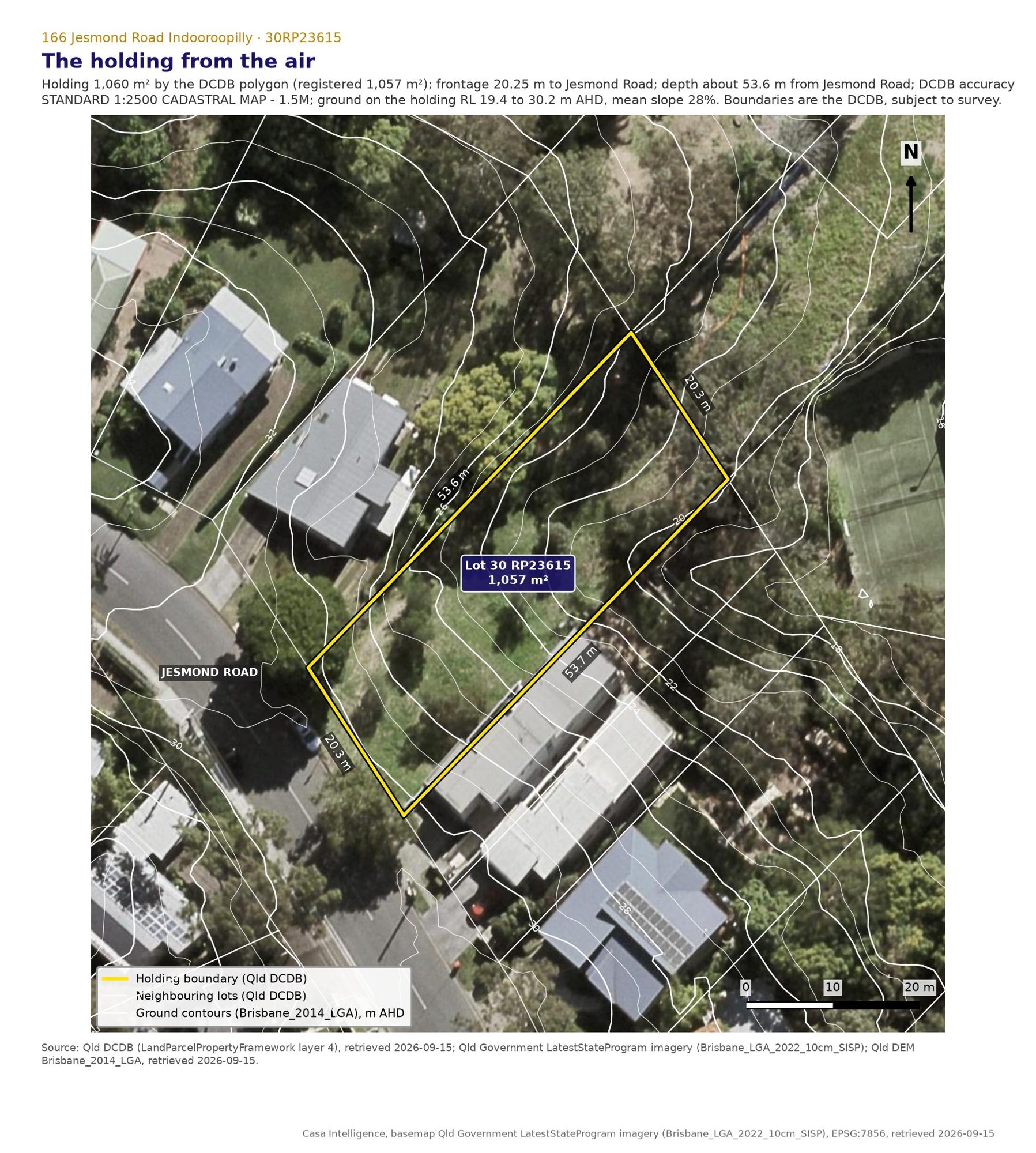
Holding 1,060 m² by the DCDB polygon (registered 1,057 m²); frontage 20.25 m to Jesmond Road; depth about 53.6 m from Jesmond Road; DCDB accuracy STANDARD 1:2500 CADASTRAL MAP - 1.5M; ground on the holding RL 19.4 to 30.2 m AHD, mean slope 28%. Boundaries are the DCDB, subject to survey.
The framework
The framework and the categories, quoted
The instrument in force is Brisbane City Plan 2014, revision 272, in force 2026-06-14. The lot is wholly in the Low density residential zone with no zone precinct, and wholly inside the Toowong to Indooroopilly district neighbourhood plan, which makes no change to the category of assessment for a material change of use (rule 18275) or for reconfiguring a lot (rule 18281). There is no priority development area, no state development area, no infrastructure designation, no temporary local planning instrument, no master plan and no structure plan requirement over this land. Where provisions conflict, the scheme's own hierarchy governs: overlays prevail over the zone and use codes, the neighbourhood plan code prevails over the zone code, and the zone code prevails over the use codes (rule 161, rule 162).
The neighbourhood plan code itself (section 7.2.20.4) is an assessment benchmark for assessable development in the plan area (rule 13737), and Council assessed the approved reconfiguration on this lot against it. Read in full, it sets no minimum site area and no minimum frontage for a dual occupancy, and its maximum building height table applies only in the Dean Street shops precinct (Table 7.2.20.4.3.B, rule 13746, rule 13761), in which this lot does not sit. That is what makes the Dual occupancy code's own Table 9.3.6.3.B the operative source of the 3,000 m2 and 40 m figures, because AO1 sends the reader to a neighbourhood plan first and only then to that table (rule 15191).
The zone code sets the expectation everything else is read against. It provides for "a variety of low density dwelling types; and community uses, and small-scale services, facilities and infrastructure, to support local residents", and its outcomes say: "Development provides for suburban living in dwelling houses of predominantly 1 or 2 storeys in height, on appropriately sized and configured vacant lots, which maintain the low density detached housing suburban identity of the Low density residential zone." "Development provides for other housing types at a house scale to provide housing diversity offering choice to different household types and individuals to suit residents through different life-cycle stages." and "Development maintains a low density character in which multiple dwellings are not accommodated." (rule 22118). A dwelling house is expected on a lot of at least 400 m2, or 600 m2 for a rear lot (rule 22116).
The categories of assessment, read from the tables today. A dwelling house is accepted development where identified in the Regulation (Table 5.4.1, rule 5312), and because the Dwelling house character overlay covers every lot in this zone, the operative row is the overlay's: accepted development "Accepted development, subject to compliance with identified requirements", the requirement being "If complying with all acceptable outcomes in the: Dwelling house code if not on a small lot; Dwelling house (small lot) code if on a small lot", and code assessment against the Dwelling house code and the zone code if any acceptable outcome is not met (Table 5.10.9, rule 13132). Subdividing one lot into two is code assessment (Table 5.4.2, rule 5315; Table 5.6.1, rule 5927), and becomes impact assessable only if a lot is under 400 m2 (300 m2 where the frontage is within 200 m walking distance of a centre zone), or under 600 m2 for a rear lot (rule 5860). A dual occupancy has no row at all in the zone table, so it falls to the catch all: "Any other use not listed in this table", assessed against the planning scheme, which is impact assessment with public notification (Table 5.5.1, rule 16904).
The built form numbers each pathway is measured against. For a dual occupancy, Table 9.3.6.3.B reads "Low density residential | – | 2 storeys and 9.5m | 3,000 | 40" across the columns zone, precinct, maximum building height, minimum site area in square metres and frontage width in metres (rule 15211), and Table 9.3.6.3.C gives, for a two storey building, "2 storeys and up to 9.5m | 4 | 6 | 4.5 | 6 | 1.5m to 4.5m 2.0m to 7.5m then 2.0m plus 0.5m /3m above 7.5m" across building height, front to balcony, front to wall, rear to balcony, rear to wall and side (rule 15220, rule 15221). For a house, the maximum height is 2 storeys and 9.5 m (rule 15277) and the side clearances come from the Queensland Development Code, which the Dwelling house code names rather than restates. For lot design, Table 9.4.10.3.B Part 1 reads "Development of a residential lot | 450 | 14 x 20 | 15" across use, minimum lot size in square metres, minimum rectangle dimension and average lot width (rule 39070).
| State layer, queried with the lot boundary on 2026-09-15 | Result | Detail |
|---|---|---|
| SEQ regional land use category (ShapingSEQ 2023) | Applies | Urban footprint (100.0%) |
| Infrastructure designation | Clear on the holding | nearest feature 287.8 m (unnamed) |
| MSES regulated vegetation: defined watercourse | Clear on the holding | nearest feature 248.5 m (unnamed) |
| State-controlled road (TMR) | Clear on the holding | nearest feature 413.7 m (CENTENARY MOTORWAY CYCLEWAY) |
| Airport areas; Coastal building line; Coastal management district; Coordinated projects (Coordinator-General); Core koala habitat area; Erosion prone area: 40 m from highest astronomical tide; Erosion prone area: calculated erosion distance; Erosion prone area: sea level rise; Koala priority area; Locally refined koala habitat area; MSES high ecological significance wetlands; MSES legally secured offset area; MSES regulated vegetation: category B; MSES regulated vegetation: category C; MSES regulated vegetation: essential habitat; MSES regulated vegetation: within 100 m of a wetland; MSES wildlife habitat: endangered or vulnerable; MSES wildlife habitat: SEQ koala habitat, core; MSES wildlife habitat: SEQ koala habitat, locally refined; Priority development areas (EDQ); Railway (existing); Railway (proposed); Railway (under construction or proposed); SEQ development area (ShapingSEQ 2023); SEQ major enterprise and industrial area (ShapingSEQ 2023); SEQ regional biodiversity corridor (ShapingSEQ 2023); State development area boundaries; Storm tide: high hazard area; Storm tide: medium hazard area | Clear on the holding | no feature returned |
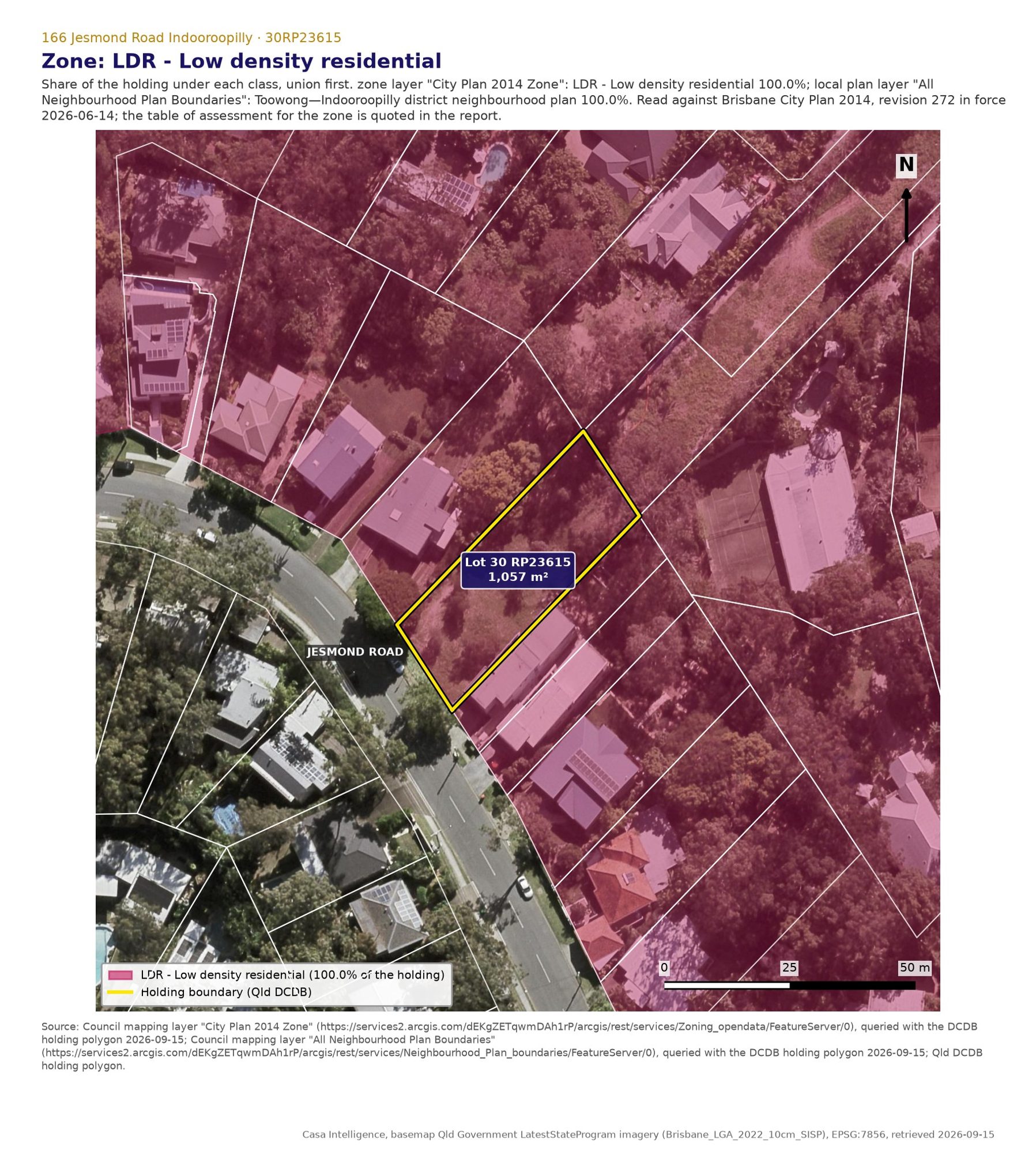
Source: Council mapping layer "City Plan 2014 Zone" (https://services2.arcgis.com/dEKgZETqwmDAh1rP/arcgis/rest/services/Zoning_opendata/FeatureServer/0), queried with the DCDB holding polygon 2026-09-15; Council mapping layer "All Neighbourhood Plan Boundaries" (https://services2.arcgis.com/dEKgZETqwmDAh1rP/arcgis/rest/services/Neighbourhood_Plan_boundaries/FeatureServer/0), queried with the DCDB holding polygon 2026-09-15; Qld DCDB holding polygon.
Overlays
The overlays, one by one
Eight overlay mapping layers, belonging to six of the scheme's overlays, return a feature over this lot. Each was queried with the lot boundary itself on 2026-09-15, and the share shown is the union of that layer's features clipped to the lot, so a figure of 2.4% means exactly that much of the land, not a yes or no. Where more than one overlay applies to the same aspect of development, the scheme takes the highest category (rule 7494), and an overlay can never lower an impact assessable use to code assessment.
On the balance of it, the overlays here are mild. The two that do work are Bushfire, which would bring the Bushfire overlay code into any application that increases the number of dwellings and which puts the whole lot in the designated bushfire prone area for building work, and Dwelling house character, which is the row that makes a new house accepted development if it meets every acceptable outcome. The rest are blanket layers that change nothing for a house, a secondary dwelling or a subdivision on this land. Four further overlays are mapped on the Jesmond Road corridor rather than inside the lot, and are set out in section 3.
| Overlay, as mapped by Council | Share of the lot | What it does to the category of assessment, and the row it is read from | Code it brings in |
|---|---|---|---|
| Dwelling house character | 100.0% | house: accepted subject to Dwelling house code AOs, else code (rule 13132); dual occupancy: no row; ROL: no row; building work for a house extension: same as house (rule 13136) | Dwelling house code |
| Bushfire: Medium hazard area | 34.6% | dual occupancy: code assessable sections A and B if not already impact (rules 11491-11492); ROL: code sections A, C, D (rule 11496); house: no change (Potential impact rows only) but designated bushfire prone area for AS 3959 (Table 1.7.1) | Bushfire overlay code 8.2.5 |
| Bushfire: High hazard buffer area | 65.4% | as above | Bushfire overlay code 8.2.5 |
| Transport air quality corridor B | 100.0% | not applicable to accepted development (rule 13504); code section B where already assessable (rule 38214) | Transport air quality corridor overlay code 8.2.23 |
| Airport environs: BBS 3-8 km and PANS | 100.0% | no change for a dwelling house (rule 7507); accepted subject to requirements or code where assessable for other MCU (rules 7508-7511) | Airport environs overlay code 8.2.2 |
| Critical infrastructure and movement network planning area | 100.0% | no residential trigger (rule 13077) | 8.2.9 |
| Potential and actual acid sulfate soils | 2.4% | trigger only for disturbance at or below 5 m AHD (rule 13309); lot's lowest ground 19.4 m AHD: none | 8.2.15 |
| Land above 5 m and below 20 m AHD | 2.7% | administrative sub-category of the ASS overlay; same test | 8.2.15 |
Note
Layers we did not query, and therefore cannot call clear: Aerial 1946; Aerial 2021; Base; Bioretention swale (Existing); Bioretention swale (Future); Bioretention swale (LTIP); Brisbane road centreline; Concrete lined channel (Future); Contours 2002; Critical routes; Culvert (Existing); Culvert (Future); Culvert (LTIP); Geometry; Interim critical routes; LGA Name; Natural channel (LTIP); Natural channel lines (Existing); Natural channel lines (Future); OLS – Runway centreline; PropertyFlag; Road Labels; SQID (Future); SQID (LTIP); SQID lines (Existing); State controlled road centreline; Street Number & Lot Plan; Suburb Name; Waterbody & Waterbody - Major; Waterway. These are base map, aerial, contour and drainage asset layers rather than categories of assessment, but they are listed because an unchecked layer is unchecked, not clear.
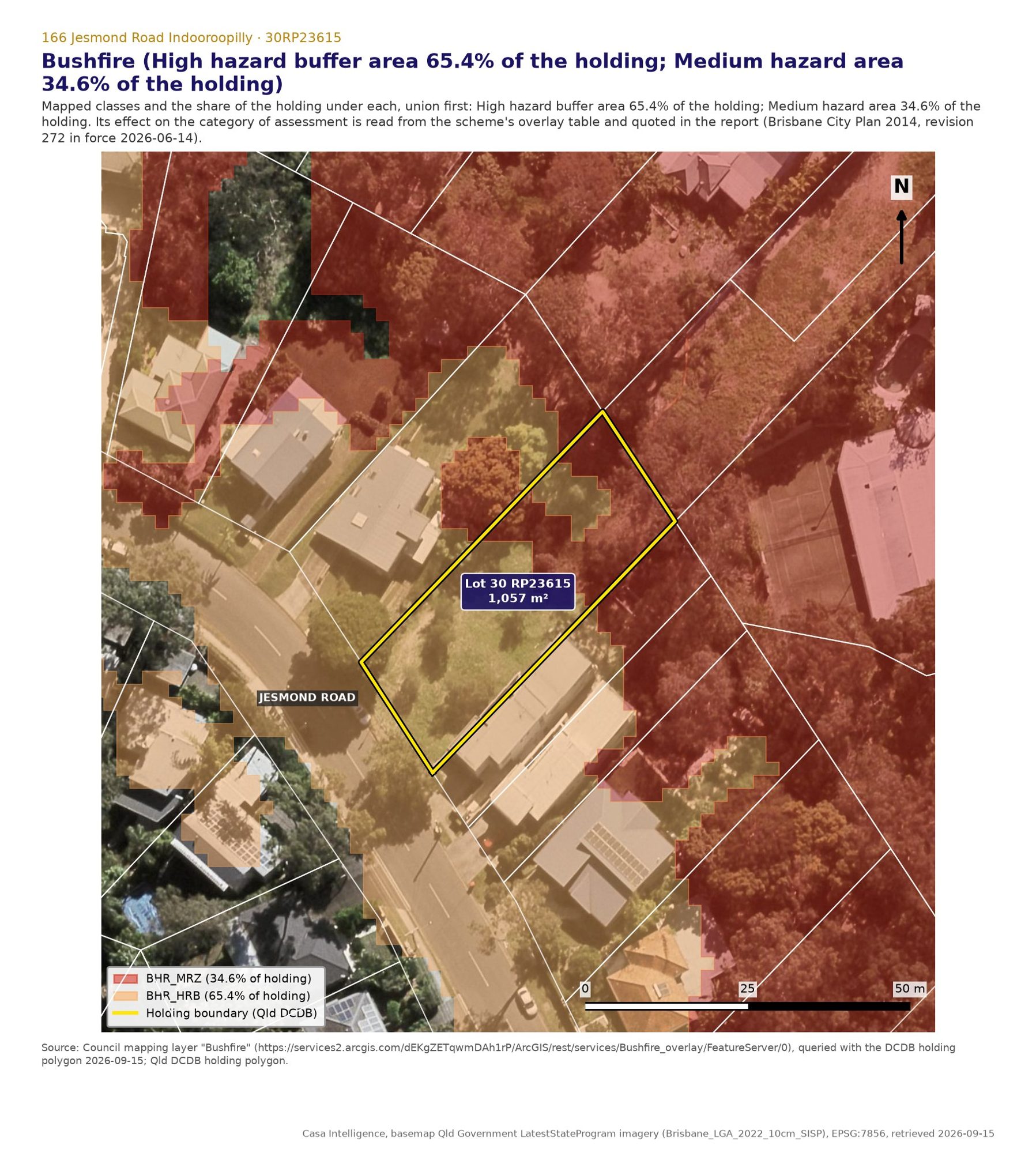
Source: Council mapping layer "Bushfire" (https://services2.arcgis.com/dEKgZETqwmDAh1rP/ArcGIS/rest/services/Bushfire_overlay/FeatureServer/0), queried with the DCDB holding polygon 2026-09-15; Qld DCDB holding polygon.
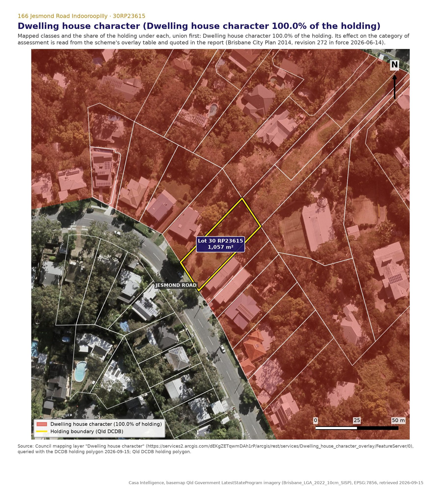
Source: Council mapping layer "Dwelling house character" (https://services2.arcgis.com/dEKgZETqwmDAh1rP/arcgis/rest/services/Dwelling_house_character_overlay/FeatureServer/0), queried with the DCDB holding polygon 2026-09-15; Qld DCDB holding polygon.
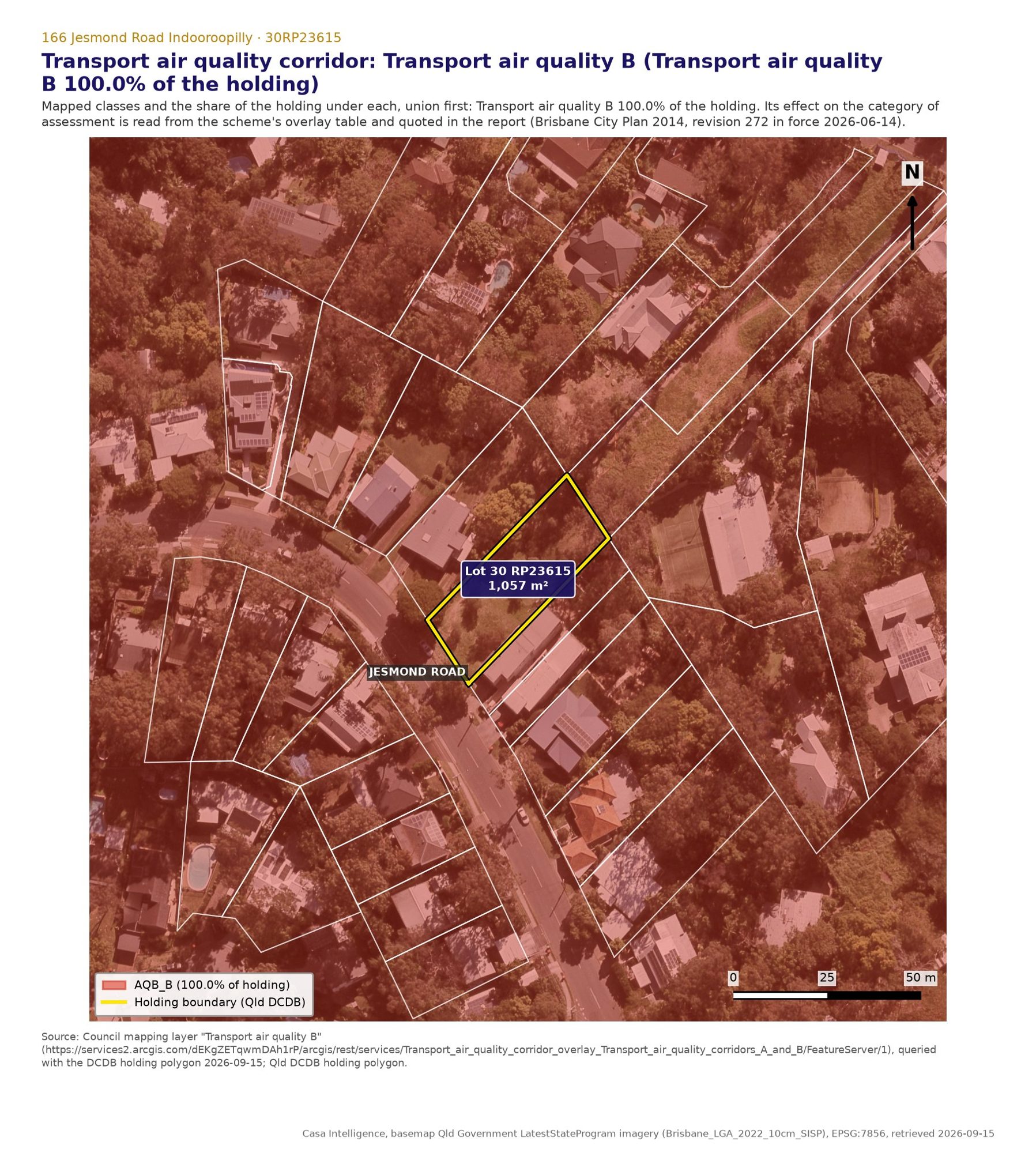
Source: Council mapping layer "Transport air quality B" (https://services2.arcgis.com/dEKgZETqwmDAh1rP/arcgis/rest/services/Transport_air_quality_corridor_overlay_Transport_air_quality_corridors_A_and_B/FeatureServer/1), queried with the DCDB holding polygon 2026-09-15; Qld DCDB holding polygon.
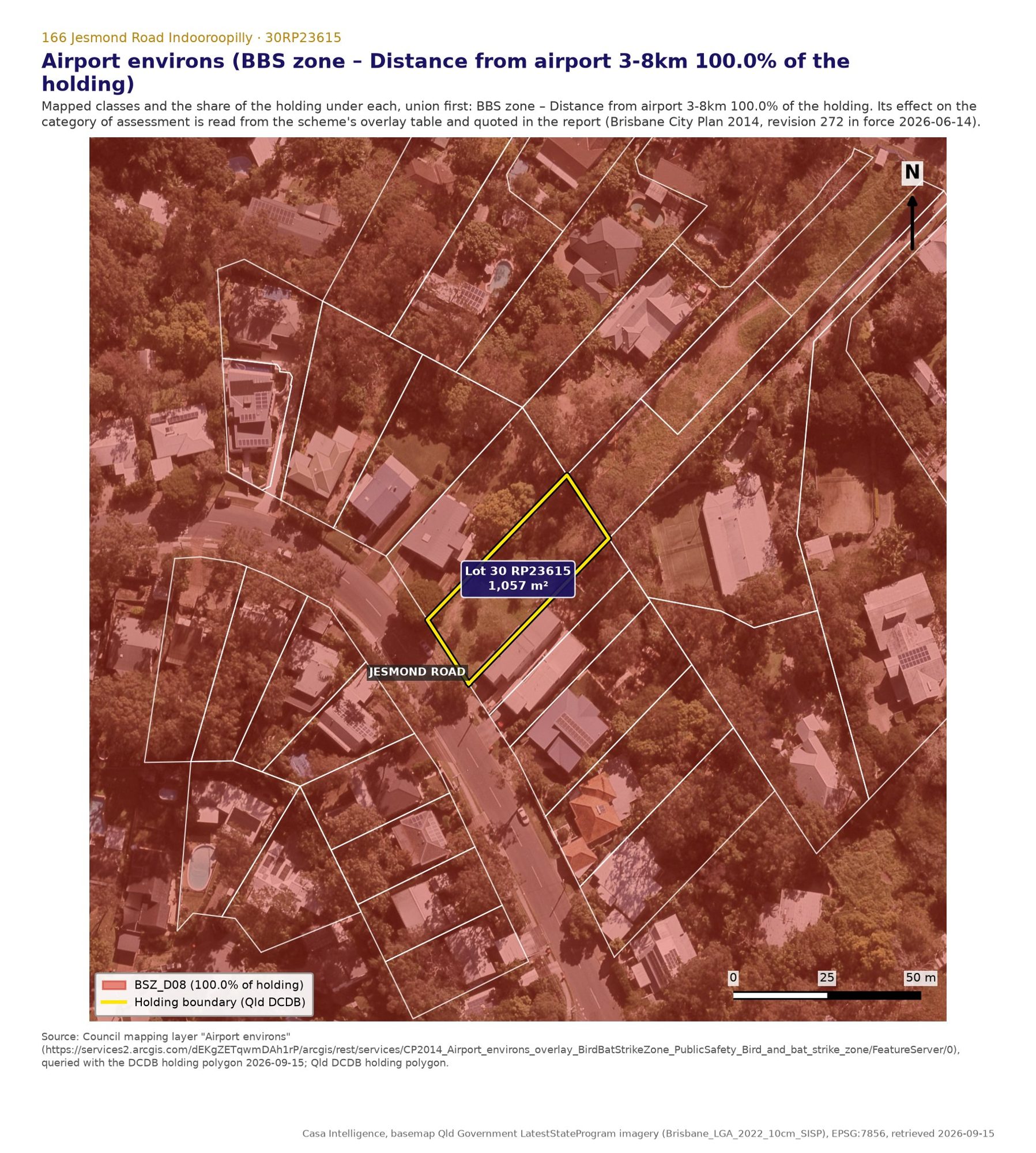
Source: Council mapping layer "Airport environs" (https://services2.arcgis.com/dEKgZETqwmDAh1rP/arcgis/rest/services/CP2014_Airport_environs_overlay_BirdBatStrikeZone_PublicSafety_Bird_and_bat_strike_zone/FeatureServer/0), queried with the DCDB holding polygon 2026-09-15; Qld DCDB holding polygon.
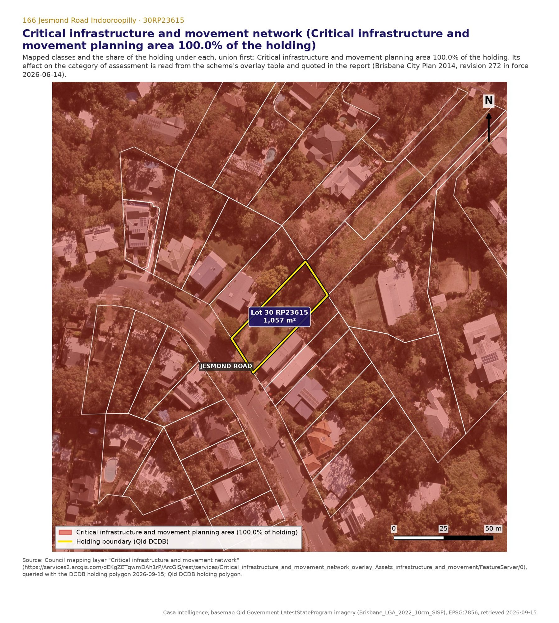
Source: Council mapping layer "Critical infrastructure and movement network" (https://services2.arcgis.com/dEKgZETqwmDAh1rP/ArcGIS/rest/services/Critical_infrastructure_and_movement_network_overlay_Assets_infrastructure_and_movement/FeatureServer/0), queried with the DCDB holding polygon 2026-09-15; Qld DCDB holding polygon.
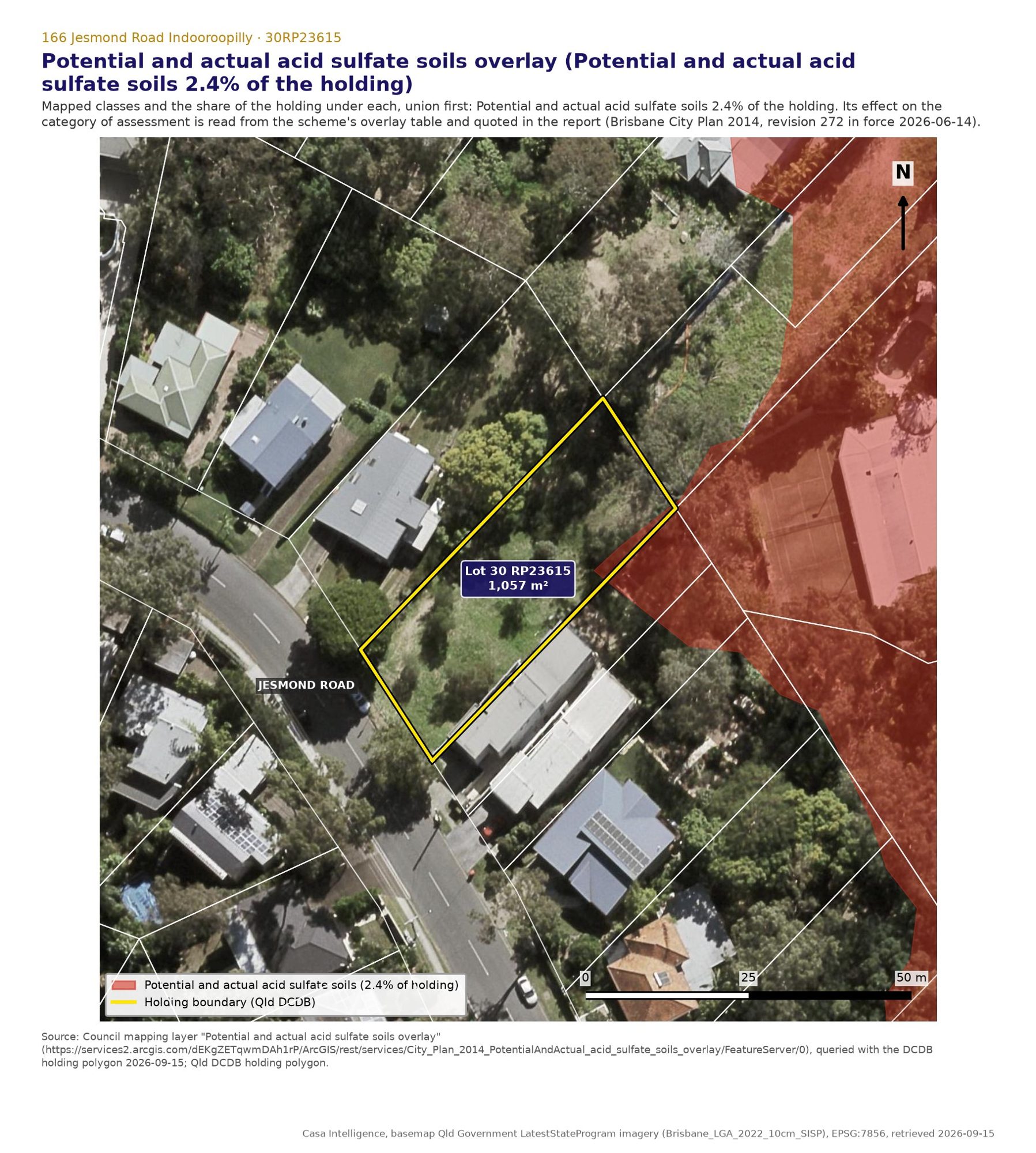
Source: Council mapping layer "Potential and actual acid sulfate soils overlay" (https://services2.arcgis.com/dEKgZETqwmDAh1rP/ArcGIS/rest/services/City_Plan_2014_PotentialAndActual_acid_sulfate_soils_overlay/FeatureServer/0), queried with the DCDB holding polygon 2026-09-15; Qld DCDB holding polygon.
The governing constraints
Slope, drainage and bushfire: the constraints that actually decide this site
There is no flood constraint on this land. Council's flood layers returned no feature over the lot, and the lowest ground on it sits at RL 19.37 m AHD. The Landslide overlay also returned no feature, so the filling and excavation triggers that overlay would bring do not apply (rule 13290). What governs this site instead is the fall of the land, where the water goes when it reaches the bottom of it, and bushfire.
Slope. The ground falls 10.88 m across the lot, from RL 30.25 at the street to RL 19.37 m AHD, with a mean slope of 27.71%, a maximum of 65.45% and 90.2% of the lot steeper than 15%. That matters in two places. In the Subdivision code, the acceptable outcome asks for the minimum rectangle from Table 9.4.10.3.B to sit on land with an existing slope of less than 1 in 5 before any earthworks; this lot does not have that, and Council said so in its information request on the approved subdivision: "The proposal has not demonstrated the minimum rectangle dimension specified in Table 9.4.10.3.B of the Subdivision code with an existing slope less than 1 in 5 prior to any earthworks, as per AO2.3 of the Subdivision code." The application was approved anyway, on the performance outcome, with dimensioned earthworks. In the building work, it means cut, fill and retaining: Council's conditions on this lot require retaining walls over 1.0 m to be certified.
Drainage. This is the issue that decides applications in this district. The lot falls away from the road, so stormwater cannot simply go to the kerb; it needs a lawful point of discharge downstream. Council raised exactly that on this lot: "The proposal must provide landowner consent from the downstream property (Lot 79 RP23615) in the absence of an existing upstream drainage connection." It was resolved by the change approved on 2026-03-06, which pipes both lots to the 225 mm connection built at the rear boundary by the subdivision behind. The weight of that is best seen in the one refusal nearby: at 88 Fig Tree Pocket Road Chapel Hill Council refused a change on 2022-09-06 in these words: "The subject site slopes to the rear and the proposed development fails to obtain a lawful point of discharge"
Bushfire. The lot is 65.4% High hazard buffer area and 34.6% Medium hazard area, which puts all of it in the designated bushfire prone area for the building code (rule 195). Practice nearby shows how this is handled rather than fought: on this lot the applicant lodged a site specific bushfire hazard assessment that found a non bushfire hazard class at every reference point, and Council listed the Bushfire overlay code among the benchmarks complied with; the same happened at 28 Jainba Street and at the two Jilba Street subdivisions. For building work, a bushfire attack level assessment goes with the building application, and the code asks for a building protection zone "building protection zone extending a minimum of 20m from the outermost projection of the main building or any habitable structure or to the maximum extent possible on sites less than 2500m2" on a site of this size.
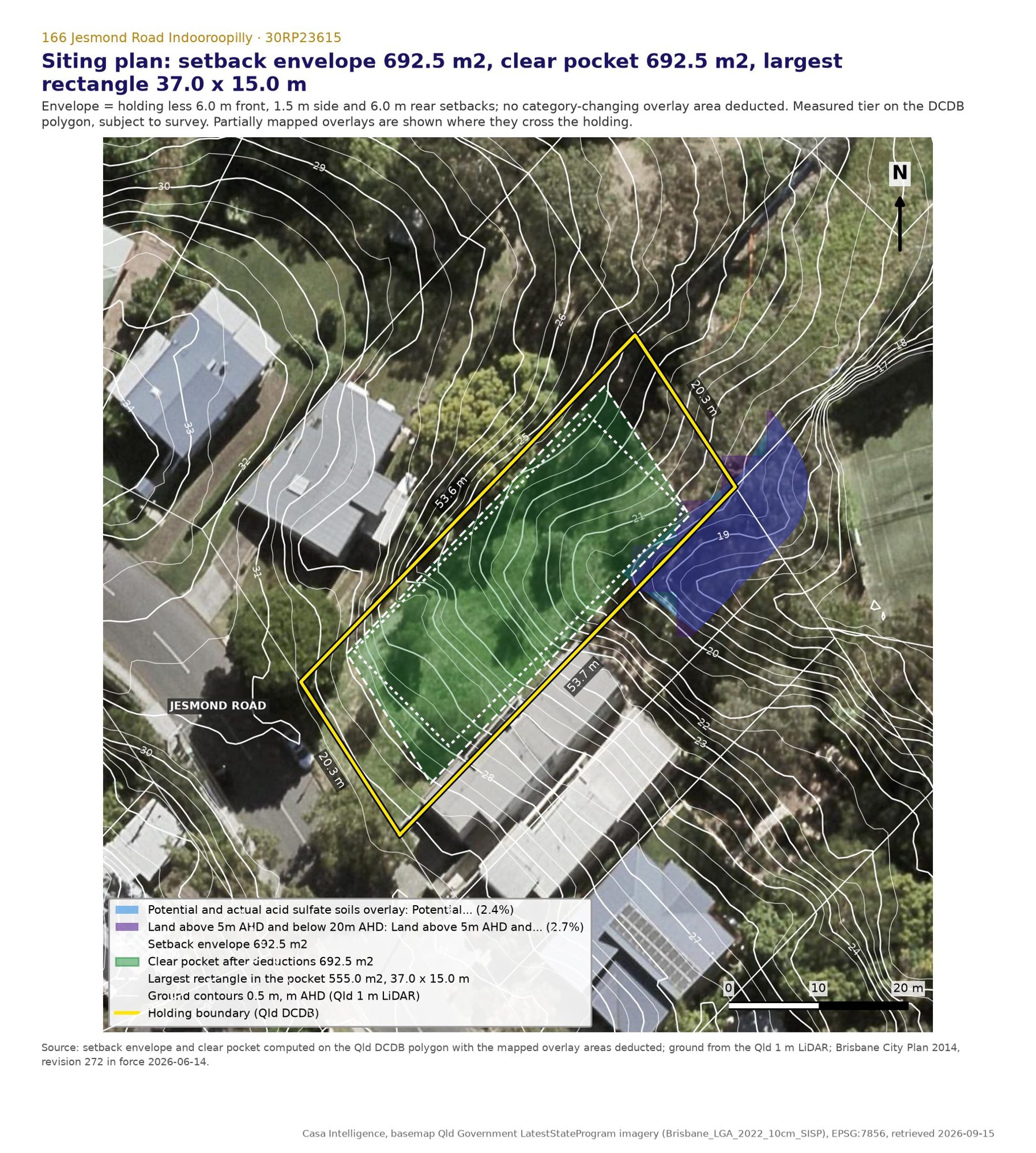
Source: setback envelope and clear pocket computed on the Qld DCDB polygon with the mapped overlay areas deducted; ground from the Qld 1 m LiDAR; Brisbane City Plan 2014, revision 272 in force 2026-06-14.
Pathway 1
Your duplex, tested
We drew it rather than argued about it. The layout is two attached two storey dwellings, each a 7.5 x 14.0 m module with three bedrooms and a tandem two car garage, set side by side with the garages to the street and the private open space to the north east at the rear. Between the two storey side setbacks there is 15.73 m of usable width, which is what allows two 7.5 m modules to sit inside the envelope with room to spare. Every number in the table below is measured off that drawing on the cadastral boundary.
You asked for separation to be proved as well. The Dual occupancy code sets no numeric separation between the two dwellings of an attached pair; separation is carried instead by the boundary setbacks (AO5 to AO7), the built to boundary rule (AO8) and the privacy outcome (AO17.1). The drawn pair is attached on the party wall, sits 2.37 m off each side boundary against the 2.0 m required, and the nearest neighbouring house is on the south eastern side behind a boundary block wall shown on Council's stamped plan; the privacy outcome and the screening it asks for were not tested and are listed in section 13.
The result is unambiguous. Front setback 6.38 m against 6.0 m required; sides 2.37 m against 2.0 m; site cover 19.9% against a 50% maximum; building length 15.0 m against 25 m; 45 m2 of private open space for each dwelling against 35 m2, facing north east off the living rooms; garages 31.6% of the frontage against a 40% maximum; 4 car spaces against 4; one driveway from the existing crossover. Every built form outcome we tested is met; privacy screening to the neighbouring house on the south eastern boundary (AO17.1), the 12 m2 covered part of each open space (AO13.1) and the vehicle swept path are design matters not tested here. The first acceptable outcome in that code is not: it asks for 3,000 m2 and 40 m of frontage, and the lot has 1,057 m2 and 20.25 m. The shortfall is a factor of about three on area and two on frontage. No layout, no variation and no overlay changes that.
So the only route is impact assessment, arguing the performance outcome that sits behind that acceptable outcome: "Development has a site area and frontage width that is sufficient to: accommodate the scale and form of dual occupancy buildings considering site features such as heritage or character buildings, significant vegetation and slope; deliver useable private open space for each dwelling; achieve safe and convenient vehicle access to the site; accommodate on-site parking and vehicle manoeuvring for residents and visitors; minimise the impact of new driveways on the streetscape and the availability of on-street parking; not adversely impact on the amenity and privacy of adjoining residents" (PO1, rule 15191). Against that, the code's own overall outcome says: "Development in the Low density residential zone is located on larger sites and reflects the low density form and character of these locations." (rule 23302), and the zone code says the zone is for "Development provides for other housing types at a house scale to provide housing diversity offering choice to different household types and individuals to suit residents through different life-cycle stages." (rule 22118). An assessment manager weighing a 1,057 m2 lot against a 3,000 m2 acceptable outcome has the code's own words on the other side of the scale, and the application would be publicly notified to neighbours on a street of detached houses.
How nearby approved applications handled the overlay this triggers. A dual occupancy would pull in sections A and B of the Bushfire overlay code, because it increases the number of dwellings (rule 11492), and section B of the Transport air quality corridor overlay code (rule 38214). Three nearby approvals show what Council accepts on the bushfire side: on this very lot (A005879370) the applicant lodged a site specific bushfire hazard assessment finding a non bushfire hazard class at every reference point, and Council listed the Bushfire overlay code among the benchmarks complied with, with no bushfire condition beyond the standard package; at 28 Jainba Street Indooroopilly (A005451059, approved 2021-01-25) in the same sub categories Council wrote that the development complies with the Bushfire overlay code; and at 43 Jilba Street Indooroopilly and 85 Jilba Street Indooroopilly (A006632449, A006141300), which carry High hazard area as well as buffer, the same assessment route was accepted. Bushfire is not what stops a duplex here. Land area is.
Nothing in the practice supports the duplex itself. We found no application for a new dual occupancy in a Low density residential zone among the 300 nearest applications on the register since 2019, which reach about 1.2 km from this lot, and none anywhere in Brisbane in our register since 2019. The one record that looked like an exception, A004989906 at 46 Pampling Street Camp Hill, is on Council's own notice in the Low medium density residential zone, where the use is code assessable on 600 m2; even there Council's information request said "The proposal does not meet the minimum site area requirements specified per AO1(b) of the Dual occupancy code". The verdict for this lot is therefore not demonstrable, and we say so plainly rather than sell you an application.
| Outcome tested | What the scheme asks | What the drawn layout achieves | Provision |
|---|---|---|---|
| Minimum site area | 3,000 m2 | 1,057 m2 | AO1, Table 9.3.6.3.B, rule 15211 |
| Minimum frontage width | 40 m | 20.25 m | AO1, Table 9.3.6.3.B, rule 15211 |
| Front setback to wall | 6.0 m | 6.38 m | AO5, Table 9.3.6.3.C, rule 15221 |
| Rear setback to wall | 6.0 m | 29.25 m | AO6.1, Table 9.3.6.3.C, rule 15221 |
| Side clearance, north west boundary | 2.0 m | 2.37 m | AO7, Table 9.3.6.3.C, rule 15221 |
| Side clearance, south east boundary | 2.0 m | 2.37 m | AO7, Table 9.3.6.3.C, rule 15221 |
| Built to boundary walls | none | none | AO8, rule 15198 |
| Site cover | 50% | 19.9% | AO11, rule 15201 |
| Combined building length | 25 m | 15.0 m | AO12, rule 15202 |
| Private open space, each dwelling | 35 m2 | 45 m2 | AO13.1, rule 15203 |
| Private open space minimum dimension | 3 m | 6.0 m | AO13.1, rule 15203 |
| Private open space orientation | north or east | north-east (lot axis bearing 43.95 deg), directly off the rear living room | AO13.2, rule 15203 |
| Covered parking as a share of the frontage | 40% | 31.6% | AO14, rule 15204 |
| On site car spaces | 4 | 4 | rule 29655 |
| Entries visible from the street | visible | both front doors on the street facade | AO15.1, rule 15205 |
| Site access driveways | 1 | 1 (existing SE crossover, max 3.5 m per stamped plan note) | AO9.2, rule 4378 |
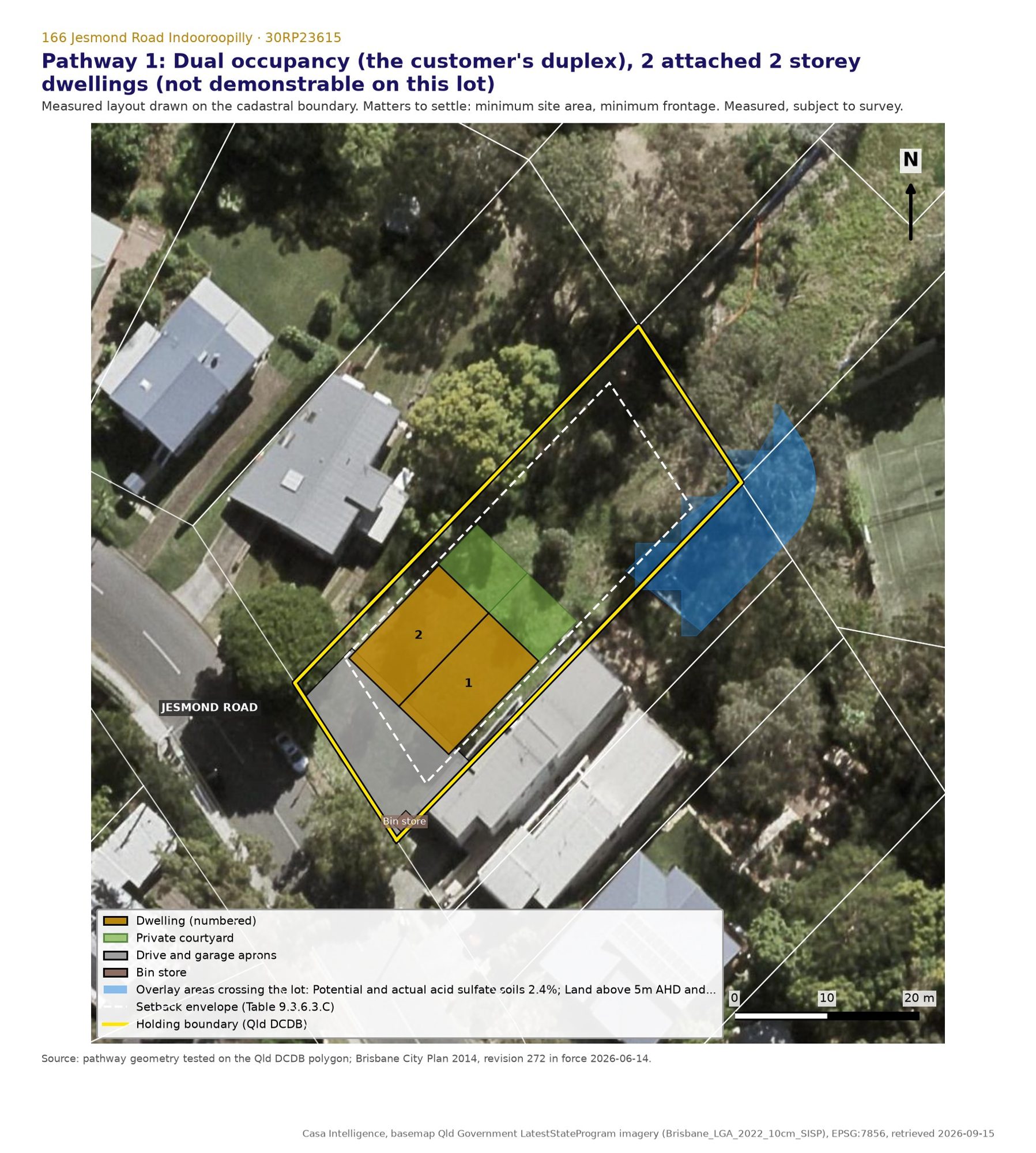
Source: pathway geometry tested on the Qld DCDB polygon; Brisbane City Plan 2014, revision 272 in force 2026-06-14.
Pathways 2 and 3
The maximum this land can hold, and what meets every acceptable outcome
Pathway 2: the two lots Council has already approved, with a house on each. This is the answer to your question about the maximum, and it is already in hand, with one qualification: the two lots were approved on the performance outcome of the Subdivision code for average lot width and minimum rectangle, not on its acceptable outcome, while each house on them can meet every acceptable outcome of the Dwelling house code. A005879370, decided 2023-03-01 and changed by A006914652 on 2026-03-06, is a Development Permit for reconfiguring one lot into two: Lot 1 527 m2 frontage 10.086 m; Lot 2 527 m2 frontage 10.071 m; depths 53.607 m to 53.740 m. On the drawn test fit, split on the cadastral polygon at the plan's own dimensions (the polygon's frontage is 20.25 m against the plan's 20.157 m), Lot 2 takes 10.07 m of frontage and measures 527 m2 and Lot 1 the remaining 10.18 m with 533 m2; the stamped plan gives 527 m2 each with frontages of 10.086 m and 10.071 m, subject to survey. Both are above the 450 m2 standard lot size (rule 39070) and both are well above the 400 m2 at which a reconfiguration in this zone would become impact assessable (rule 5860), so neither is a small lot and the Dwelling house code, not the small lot code, applies to the house on each.
What fits on each new lot. Between the two storey side clearances there is 5.92 m of usable width on Lot 1 and 5.8 m on Lot 2 as drawn (about 5.8 m on each at the plan's own frontages, the lot width being the frontage times the cosine of the 13.1 degree skew, less 2.0 m each side). That takes a house of 5.92 x 14.0 m (83 m2 of footprint) on Lot 1 and 5.8 x 14.0 m (81 m2) on Lot 2, at front setbacks of 6.3 m and 8.55 m with 2.0 m side clearances, and leaves room for a secondary dwelling of 53 m2 behind one house and 52 m2 behind the other, both inside the 80 m2 cap and within 20 m of their house (rule 15276). Site cover lands at 25.6% and 25.3%. Each house is a narrow one; that is the price of two 10 m frontages on a 20 m lot, and it is why Council approved the lot widths on the performance outcome rather than the acceptable one.
The pathway for pathway 2. The reconfiguration needs no new application: it is approved, and what remains is to satisfy the conditions, obtain the operational work permit, build the stormwater connection, pay the levied charge when Council approves the plan of reconfiguration, and give Council the plan of subdivision before 31 May 2027. Each house then needs no development application either, provided it meets every acceptable outcome of the Dwelling house code (rule 13132); it still needs a building approval and a bushfire attack level assessment. If a design misses an acceptable outcome, the house becomes code assessable against the Dwelling house code and the zone code, which is an application but not a notified one.
Pathway 3: one house plus a secondary dwelling, leaving the lot whole. If the subdivision is not wanted, the lot as it stands carries two dwellings today. The Dwelling house code's first acceptable outcome allows "not more than one dwelling house and one secondary dwelling, each occupied by one household" (AO1.1, rule 15276), and a secondary dwelling is "a maximum of 80m2 in gross floor area; located within 20m of the dwelling house." (AO1.2). Parking is 1 car parking space for the dwelling house; 1 car parking space for any secondary dwelling on the same site (AO4, rule 15279). The test fit puts a two storey house at 6.72 m from the frontage with 3.87 m side clearances and a 76 m2 secondary dwelling 6.0 m behind it, at 25.4% site cover. This is accepted development on the same terms as pathway 2, and it does not use up the subdivision approval. The trade off is that the second dwelling cannot be sold separately: one title, and the secondary dwelling stays subordinate to the house.
Which is better. If the object is value, pathway 2: two separately saleable titles in Indooroopilly with a house on each, on an approval that is already granted and already charged. If the object is one household with a second dwelling for family or rent, pathway 3 gets there without the subdivision cost, the operational work and the deadline. Pathway 2 does not foreclose a secondary dwelling later; it allows one on each of the two lots.
Note
Pathway 2 is the maximum this land can hold, and it is already approved: two lots, a house on each, and a secondary dwelling of up to 80 m2 behind each house. Four dwellings in total on two titles, none of them requiring a notified application, all of them conditional on meeting every acceptable outcome of the Dwelling house code and on the subdivision being completed before 31 May 2027. One qualification belongs on it: the subdivision itself does not meet every acceptable outcome of the Subdivision code. Table 9.4.10.3.B asks for an average lot width of 15 m and a 14 m x 20 m minimum rectangle for a standard lot (rule 39070), and Council's information request of 13 December 2021 records that the reconfiguration relies on the performance outcome, PO1, for average lot frontage and minimum rectangle dimension. Council approved it on that outcome, the approval is granted and current, and the point is not reopened. What meets every acceptable outcome is each house on those lots, against the Dwelling house code.
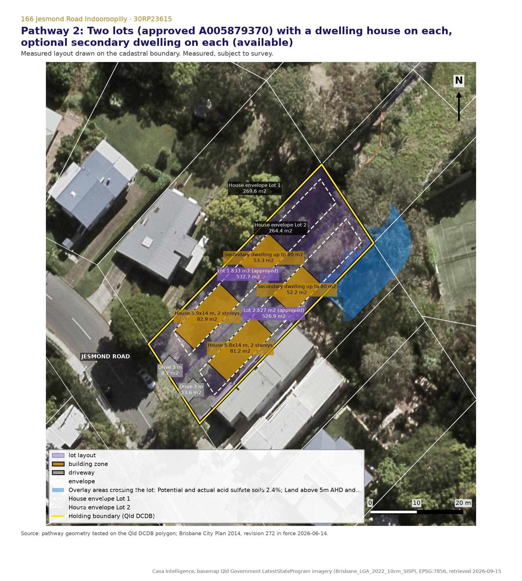
Source: pathway geometry tested on the Qld DCDB polygon; Brisbane City Plan 2014, revision 272 in force 2026-06-14.
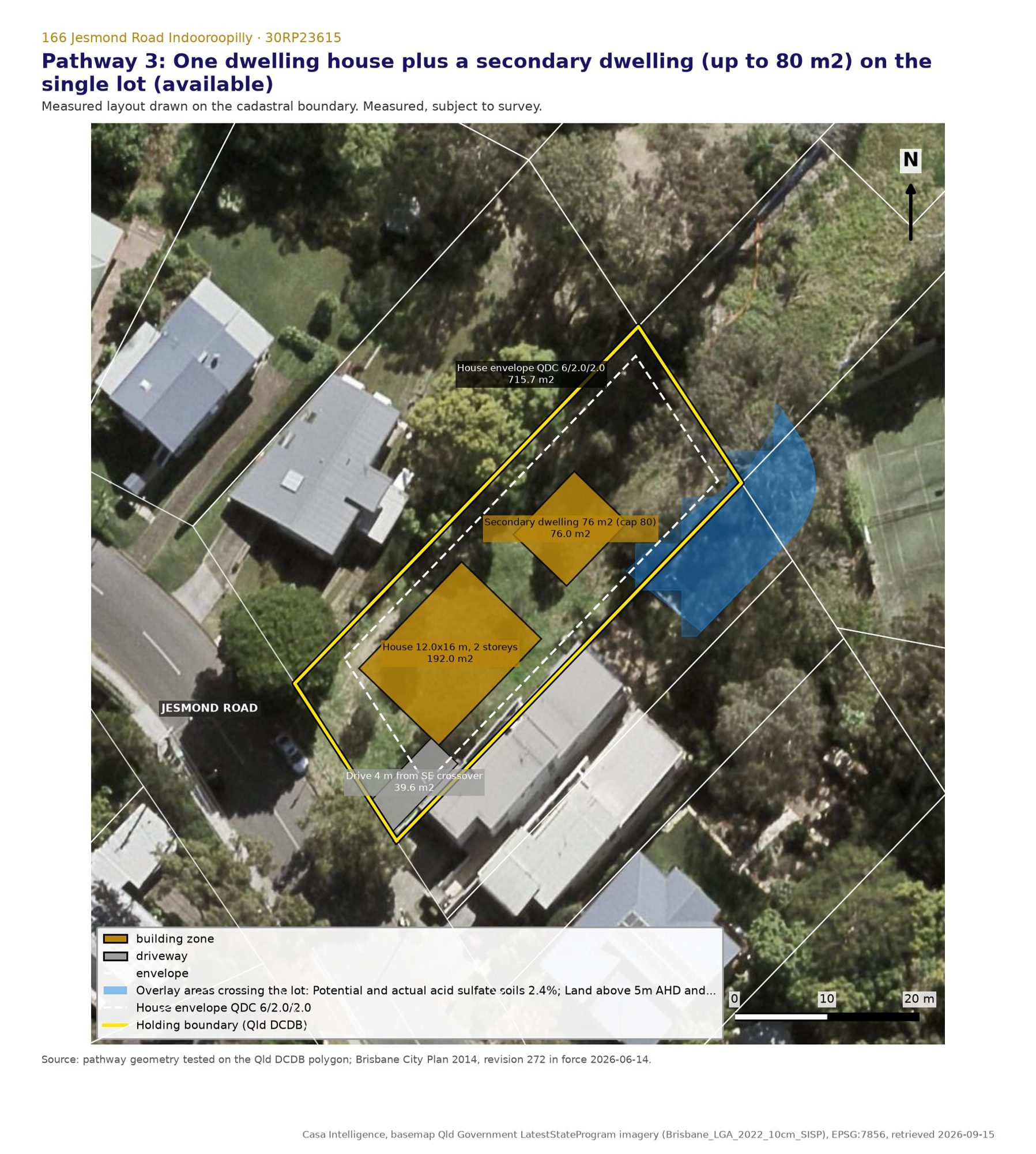
Source: pathway geometry tested on the Qld DCDB polygon; Brisbane City Plan 2014, revision 272 in force 2026-06-14.
Access
Access, driveway widths and the crossover
What the code says. Development that is not major development provides "a single site access driveway in the road area to the lowest order road to which the site has frontage" (AO9.2, rule 4378), so one crossover serves this lot however it is developed. The driveway standard is Council's own: "Access driveway design is shown on BSD-2021 and BSD-2022 (for a dwelling house)." (rule 27084). The Subdivision code sets the widths: "... internal driveways serving a single dwelling that are a maximum of 3m wide; driveways serving more than 3 lots that are at least 4m wide." (AO36.1). For a house, one on site space is required, plus one for a secondary dwelling (AO4, rule 15279); for a dual occupancy, "Dual occupancy | 1 space per 1 or 2 bedroom dwelling" for one or two bedroom dwellings and two spaces for three or more bedroom dwellings, which may be in tandem (rule 29655).
What is there now, measured. There is one existing crossover at the south eastern end of the 20.25 m frontage, sitting inside the canopy of a street tree about 9 m tall. Council's stamped plan for the approved subdivision carries the note "Maximum 3.5m wide residential type crossover", which sets the ceiling on its width. The ground falls steeply from the road, so the grade transition at the crossover is the constraint that matters, not the width: Council said so on this lot in its information request, "Access must be in accordance with the City Plan standard drawings BSD-2022 and BSD-2024 ensuring maximum grade transitions are not exceeded."
What that means for each pathway. Pathway 2 gives each new lot its own frontage, so each takes its own crossover and a driveway serving a single dwelling, at the standard width; the existing crossover serves one of them and the street tree governs where the second one goes, which is why Council's conditions on this lot and on the comparable approvals nearby require street trees at crossovers to be retained and protected. Pathway 1 and pathway 3 keep one lot, so one crossover and one driveway serve everything; on the duplex layout that is a shared drive at the south eastern side feeding two tandem garages, which is what holds the covered parking to 31.6% of the frontage against the 40% maximum.
What was not tested. Vehicle swept paths were not modelled, and the driveway grades were not designed against the standard drawings. Both are design work for the next step, and both are listed in section 13 as matters for resolution. What this report establishes is that the code's access requirements can be met on the measured geometry, not that a particular driveway has been engineered.
Practice
What Council has actually decided nearby, and this lot's own history
This lot's own history is the most useful record in the file. On 2023-03-01 Council approved A005879370, reconfiguring one lot into two, with a currency period to 31 May 2027. Its statement of reasons reads: "Subject to the development conditions contained within the attached approval package, the development is able to comply with the applicable assessment benchmarks against which the application was required to be assessed." In its information request of 13 December 2021 Council raised four things, and all four were resolved: justification against PO1 of the Subdivision code for average lot frontage and minimum rectangle dimension, the minimum rectangle on slope under 1 in 5, access to the standard drawings, and a lawful point of discharge through the downstream property. On 2026-03-06 Council approved A006914652, a change under section 81 of the Planning Act 2016 that simplified the earthworks, stormwater and erosion conditions and piped both lots to the connection built by the subdivision behind. Council's notice on that change records: "The requested change does not result in an amended infrastructure charges notice." There is no material change of use approval and no building approval on the land; it is vacant, and the plan of subdivision has not yet been registered, so it remains one lot on the cadastre.
The charge, from a real notice. ICN-024874, dated 2023-03-01, levied $15,498.37 on this lot for one extra lot of demand, after a credit of one lot for the lot that already exists, across Council's stormwater, transport, public parks and land for community facilities networks. The notice states that the charge is payable, for reconfiguring a lot, when Council approves the plan of reconfiguration; the amount payable at that time comes from the Infrastructure Charges Quote. Urban Utilities charges for water and sewer are separate and are not on Council's notice. Comparable notices nearby, each read from the notice itself, run from $15,498.37 at 168 Jerrang Street Chapel Hill in 2023 (ICN-024320, Resolution No. 11), through $16,079.07 at 85 Jilba Street in 2024 (ICN-026235, Resolution No. 12) and $17,034.48 at 43 Jilba Street in 2025 (ICN-027733, Resolution No. 13), to $18,026.28 at 21 Jainba Street in February 2026 (ICN-029616, Resolution No. 14). The notice on this lot says that the levied charge may be increased from the date of the notice to the day it is paid by the Producer Price Index, and that an Infrastructure Charges Quote must be requested before payment showing the amount payable at that time; it is the indexed 2023 figure that is payable, not a fresh charge under the current resolution. For comparison only, Resolution (No. 15) 2026 sets the adopted charge at $18,793.33 for each additional lot, and the same amount for each three or more bedroom dwelling.
The pattern in the district. Of the applications we read in full, eight reconfigurations of one lot into two or three lots, counting this lot's own approval, were approved within about 700 m of this land since 2019, including the lot immediately behind, and a ninth approval at 106 Boundary Road Indooroopilly reconfigured two lots into three. The register itself lists 48 approved records of the type reconfiguring a lot, at 33 addresses, within 1.2 km since 2019 (the nearest 300 applications, reaching 1,221 m), counting this lot's two and 14 change requests to earlier approvals; the eight are the nearest ones and the ones whose notices we read, not the whole count. Council's recurring conditions on them are consistent: retain and protect street trees at crossovers, certify retaining walls over 1.0 m, kerbside refuse collection, and written downstream consent for the lawful point of discharge. The closest comparable in size and zone is 43 Jilba Street Indooroopilly (A006632449), a 1,067 m2 lot in this zone split into two with a shared access and approved on 2025-03-20; and the steepest is 168 Jerrang Street Chapel Hill (A006139590), approved with a 424 m2 lot on slopes over 1 in 3.
And the two refusals, which say more than the approvals. At 88 Fig Tree Pocket Road Chapel Hill a change to the stormwater solution was refused on 2022-09-06 because the site fell to the rear and no lawful point of discharge had been obtained. At 37 Fig Tree Pocket Road Chapel Hill (844 m from the subject) a new house on a small lot was refused on 2019-06-13 for exceeding the maximum building height and for not being "consistent with building height of dwelling houses prevailing in the immediate vicinity". Those two, drainage and height, are the district's live issues, and both are manageable here. No refusal, and no approval, of a new duplex in this zone appears anywhere in the record we searched.
| Application | Address and distance from the lot | What was applied for | Council's decision | Decided | Charge levied |
|---|---|---|---|---|---|
| A005879370 | 166 Jesmond Road Indooroopilly (subject lot, 30RP23615) | Reconfiguring of a lot (1 into 2) lots | Approved | 2023-03-01 | $15,498.37 |
| A006914652 | 166 Jesmond Road Indooroopilly (subject lot) | Change under s81 of the Planning Act 2016 to Reconfiguring a Lot (1 into 2 lots) | Approved (minor change) | 2026-03-06 | not on the notice read |
| A005451059 | 28 Jainba Street Indooroopilly (adjoins the rear of the subject lot; 3SP353990 is a lot of that subdivision) | Reconfiguring a Lot (1 into 3, and Access Easement) | Approved | 2021-01-25 | not on the notice read |
| A006141300 | 85 Jilba Street Indooroopilly | Reconfiguring a Lot (1 into 2 Lots) | Approved | 2024-01-12 | $16,079.07 |
| A006632449 | 43 Jilba Street Indooroopilly | Reconfiguring a lot (1 into 2 lots) | Approved | 2025-03-20 | $17,034.48 |
| A006890606 | 21 Jainba Street Indooroopilly | Reconfiguring a lot (1 into 2 lots) | Approved | 2026-02-20 | $18,026.28 |
| A006139590 | 168 Jerrang Street Chapel Hill | Reconfiguring a Lot (1 into 2 Lots) | Approved | 2023-06-29 | $15,498.37 |
| A005887926 | 36 Jainba Street Indooroopilly | Reconfiguring a Lot (1 into 3 Lots, and access easement) | Approved (register status; Council notice not downloaded) | 2022-11-03 | not on the notice read |
| A005713895 | 270 Jesmond Road Fig Tree Pocket | Reconfiguring a Lot (1 into 2 Lots) | Approved (register) | 2021-09-22 | not on the notice read |
| A005827821 | 106 Boundary Road Indooroopilly | Reconfiguring a Lot (2 into 3) | Approved (register) | 2022-02-25 | not on the notice read |
| A005692116 | 88 Fig Tree Pocket Road Chapel Hill | Request to change the development approval under s81 (alternative stormwater discharge solution for a subdivision) | Refused | 2022-09-06 | not on the notice read |
| A005148797 | 37 Fig Tree Pocket Road Chapel Hill (844 m from the subject) | New Dwelling house on a Small Lot (3 Storeys) | Refused | 2019-06-13 | not on the notice read |
| A004989906 | 46 Pampling Street Camp Hill | Dual Occupancy in the Flood overlay; Reconfiguring a lot 1 into 2 lots (and common property) | Approved | 2019-02-26 | not on the notice read |
Next
What to do next, in order of leverage
1. Decide about the subdivision approval before 31 May 2027. It is the single most valuable thing this land holds and it has an end date. Everything below assumes you intend to use it; if you do not, say so early, because the operational work and survey lead times run to months, not weeks.
2. Order a title search. Nothing in this report reflects what is registered on title, and easements, covenants and building envelopes can only come from there.
3. Commission an identification and contour survey. Every boundary, area, frontage and level here is measured from the State cadastre and the 1 m laser survey, and the cadastre's stated accuracy is 1.5 m. The lot widths on the approved plan are about 10 m; that is not a dimension to design against without a surveyed boundary.
4. Get the operational work permit moving: earthworks, retaining, the driveway crossovers and the stormwater connection to the rear, all as conditioned. A geotechnical investigation belongs here too, on a lot with a mean slope of 27.71% where retaining over 1.0 m must be certified.
5. Request an Infrastructure Charges Quote from Council before the plan of subdivision is given to it, so the indexed amount payable is known rather than assumed. The 2023 notice on this lot is $15,498.37, increased by the Producer Price Index to the day of payment under the notice's own terms; for comparison, the adopted charge under Resolution (No. 15) 2026 is $18,793.33 for each additional lot. Confirm the Urban Utilities charge separately.
6. Design each house to the Dwelling house code's acceptable outcomes, in particular the 2 storeys and 9.5 m height outcome, and confirm the setback source at the time, since the Queensland Housing Code is listed as replacing the Queensland Development Code parts the code points to. Staying inside those outcomes is what keeps each house accepted development rather than an application.
7. Order the bushfire attack level assessment with the building application, and keep the 2021 site specific bushfire assessment on this lot in the file; it found a non bushfire hazard class at every reference point and is the kind of material Council has accepted here.
8. If you still want the duplex after all of this, ask Council for a pre lodgement meeting before spending anything on a design. Take this report's table of tested outcomes to it. The answer to expect is the code's own: 3,000 m2 and 40 m, on a lot with 1,057 m2 and 20.25 m.
Risk
What could change this answer
Every conclusion in this report is an assessment of record: it is what the scheme in force on 2026-09-15 says, measured against what the State cadastre, the State laser survey and Council's live mapping show, and tested against what Council has actually decided nearby. The table below sets out what could move it, how likely that is and on what basis, what it would do, and what closes it out. None of these risks touches the central finding: the duplex fails on land area and frontage, and the two lot approval, with a house on each lot built to every acceptable outcome of the Dwelling house code, is the maximum this land can hold.
| What could change this answer | How likely, and on what basis | Effect if it happens | How it is closed out |
|---|---|---|---|
| The two lot approval lapses | Certain unless acted on: the permit's currency ends 31 May 2027 | The two lot layout would have to be applied for again, against whatever scheme is in force then | Give Council the plan of subdivision, with the conditions met, before that date |
| The charge payable is more than the amount levied in 2023 | Certain in direction: the notice states that the levied charge of $15,498.37 is increased by the Producer Price Index from 1 March 2023 to the day of payment; the adopted charge under Resolution (No. 15) 2026, $18,793.33 for each extra lot, is context only | More cash at the time Council approves the plan | Request an Infrastructure Charges Quote from Council before the plan is given to it |
| Stormwater to a lawful point of discharge | Low on this lot, and the single biggest risk in this district: the 2026 change plan pipes both lots to the connection built by the subdivision behind, and the one refusal nearby turned on this | Without a lawful point of discharge the subdivision cannot be completed | Build the connection as the conditions require, and keep the downstream consent current |
| Earthworks and retaining on the fall | High: mean slope 27.71% and 90.2% of the lot steeper than 15%, from the 1 m laser survey of the ground | Deeper cut and taller retaining walls than a flat lot, and a possible reshaping of each house | A geotechnical investigation and certified retaining design, with the operational work permit |
| Bushfire attack level at building approval | Certain: the lot is in the designated bushfire prone area, 65.4% in the High hazard buffer area and 34.6% in the Medium hazard area | Construction to a bushfire attack level, which adds cost to the building work | A site specific bushfire assessment with the building application, as was lodged on this lot in 2021 |
| House height against the prevailing height nearby | Low if the design stays within 2 storeys and 9.5 m: the one refusal of a house in the district was for exceeding it | A house above that height turns an accepted house into a code assessed one and risks refusal | Design to the height outcome, and count the heights of the houses within 35 m of the frontage |
| The setback source for a house changes | Moderate: the Queensland Housing Code commenced on 1 September 2026 and replaces the Queensland Development Code parts that set house setbacks as each council adopts it over a three year transition; Brisbane's adoption status was not read and the Code's text could not be obtained, so MP1.2 is used | The side and rear clearances used for each house could move | Read the Housing Code and Council's transition position before the house design is fixed |
| Boundaries and area move on survey | Moderate: the State cadastre gives 1059.59 m2 against a registered 1057.0 m2, and its stated accuracy is 1.5 m | Setback and lot area numbers shift slightly; none of the conclusions turn on that margin | An identification survey by a licensed surveyor |
| The scheme is amended | Possible: the categories in this report are read from revision 272, in force 2026-06-14, as at 2026-09-15 | A new revision can change a category of assessment or an acceptable outcome | Re-read the tables of assessment at the time of lodgement |
Honesty layer
What this report does not cover
- The title was not searched. Easements, covenants, building envelopes and any other encumbrance registered on title are unknown until a title search is done, and any of them can restrict where and what may be built. The State cadastre records no easement over the lot, which is not the same thing as a clear title. Resolved by a title search.
- Where this lot forms part of an estate subdivision, estate covenants commonly restrict dwelling form, materials, roof pitch, fencing and minimum floor area, and they bind regardless of what the planning scheme allows. They are registered on title and must be read before any design is fixed. Resolved by the same title search.
- Queensland Housing Code (14 August 2026 edition, listed on the QDC page as replacing MP1.1 and MP1.2 from 1 September 2026) could not be fetched; its adoption status for Brisbane not read. Resolved by: read the Housing Code PDF and the Brisbane transition notice; until then MP1.2 numbers are an assumption row and the report says so.
- Planning Regulation 2017 Schedule 6 Part 2(2) not read from legislation.qld.gov.au. Resolved by: read the Regulation; the scheme's s5.4 (revision 272) is relied on as Council's own restatement.
- Title not searched (covenants, building envelopes, easements other than DCDB parcels). Resolved by: title search.
- Conditions package, plan and ICN for A005887926 (36 Jainba), A005713895 (270 Jesmond), A005827821 (106 Boundary) not read. Resolved by: fetch with precedents docs; register outcomes only are recorded.
- Vehicle swept paths not modelled. Resolved by: run the sweptpath model for a B99 at the crossover in the design phase; the layouts use street-fronting garages with short aprons.
- Building heights of houses within 35 m of the frontage (PO2 'prevailing in the immediate vicinity') not counted. Resolved by: site inspection; the stamped plan shows two-level neighbours (floor levels RL 30.11 and 28.855 on 31RP23615).
- Urban Utilities water and sewer charges for the approved subdivision. Resolved by: UU infrastructure charges notice.
- Community purposes network overlay is listed over this lot on Council's Notice about Decision for A005879370, but none of its 12 mapping layers returns a feature within 30 m of the lot today. Resolved by: confirm with Council's planning and development online mapping at lodgement; treat the Community purposes network overlay code as a potential benchmark for any assessable application.
- Boundaries, areas, frontages, depths and clearances in this report are measured on the State digital cadastre, whose stated accuracy on this lot is 1.5 m, and on Council's stamped plan. The cadastral polygon measures 1,059.59 m2 against a registered 1,057 m2. Nothing here is a surveyed dimension. Resolved by an identification and contour survey.
- Levels and slopes are taken from the State 1 m bare earth laser survey, which is a model of the ground surface and not a set of surveyed spot levels. Resolved by the same survey.
- The layouts drawn in this report are test fits used to prove what the scheme's outcomes allow on the measured geometry. They assume a dwelling module of 7.5 x 14.0 m and a car space of 2.4 x 5.4 m, neither of which the scheme fixes. They are not a design, and they were not prepared by a building designer or engineer. Resolved at design stage.
- No site inspection was made, so the condition of the existing crossover, the street tree, the neighbouring block wall on the south eastern boundary and the state of the rear stormwater connection are taken from Council's stamped plans and the 2022 aerial photography, and the sewer main shown on the stamped plan was not located on the ground nor were the drawn building zones offset from it. Resolved by a site inspection and an Urban Utilities asset search.
- Council's live mapping and the State trigger mapping were queried on 2026-09-15. Mapping is amended between scheme revisions, and a layer that returns no feature today can return one later. Resolved by re-querying at lodgement.
Deterministic site plan
Site Analysis Plan
This is a real Casa Intelligence report, prepared on a real property using public planning and cadastral data. The property was selected from public listing and development-application records and we have no connection with its owner. Prepared 15 September 2026 against the planning scheme in force on that date.
Pre-delivery audit and planner pass recorded 15 September 2026. Site-constraint gate for the modelled scenario (dual_occupancy): pass. If you are the owner of this property and would like this page removed, email hello@casaintelligence.com.au and it comes down within two business days, no questions asked.
This report is an assessment of record prepared by Casa Intelligence Pty Ltd for the party named on the cover. Every category of assessment, minimum, setback and charge in it is taken from the primary source cited beside it: Brisbane City Plan 2014 as published on Council's electronic planning scheme, the Queensland digital cadastral database, the Queensland 1 m laser survey, Council's live mapping services and Council's own decision notices, information requests, conditions, stamped plans and infrastructure charges notices, each read on the date stated. It is general planning information, not planning advice and not legal advice, and it is not a guarantee that any application will be approved: assessment is a matter for the assessment manager on the material before it. Casa Intelligence does not act as planner of record for any application arising from this report. Measured values are subject to survey. Design stage work, being survey, geotechnical investigation, stormwater design, services investigation and title searching, has not been carried out and is identified as the next step.