Site Possibilities
Secondary dwelling: the most this block will take
6 Finlay Street Slacks Creek QLD
Low density residential zone, SU - Suburban precinct, Logan
- Report reference
- CI-20260915-SLC
- Issued
- 2026-09-15
- Scheme in force
- Logan Planning Scheme 2015 (v9.2 + TLPI No. 1 2024), revision 203 in force 2025-06-25
- Prepared for
- Published as a sample
The answer
Yes.
A detached granny flat of 70 square metres fits behind your house on the flat part of the back yard, and it is the largest one the rules allow on a block this size, measured to the outside of the external walls, so it has to be set out to that line exactly. We have drawn it to scale at 7.0 by 10.0 metres with its roof edge 1.53 metres off the eastern boundary (the wall at 2.13) and 2.12 metres off the back fence (the wall at 2.72), with a 30 square metre yard of its own, a 1 metre path from the street and two extra car spaces at the mouth of the carport, straight off the crossover you already have. The floor area, the setbacks, the site cover and the parking dimensions each meet an acceptable outcome of the scheme, and the frontage of 18.49 metres clears the only frontage number the code carries. The 30 square metre yard and the 1 metre path are our own design assumptions; the scheme sets no private open space or path number for a secondary dwelling, and the separation from the house is a building rule for the certifier. Council has approved this kind of unit three times within 800 metres of here and once more about a kilometre away, and we found no refusal in the records we read. If the building is built that way, and connected to Council's water and sewer, whose mains we have not located, no development application goes to Council at all: you need only a building approval from a private certifier, and the infrastructure charge of $26,193.40 for a two bedroom dwelling is levied on that approval and becomes payable when the building's final inspection certificate is issued, indexed by Council's resolution from the day it is levied to the day it is paid.
What it will not do is get bigger. 70 square metres is the ceiling on a lot under 1,000 square metres, and the scheme puts the same number in the performance outcome as in the acceptable outcome, so there is no argument that buys you a larger unit. The block also cannot be split in two, because the smallest pair of lots the scheme will accept adds up to 800 square metres side by side, or 900 where one lot sits behind the other, and you have 766.
The one fact that shapes everything else is that no car can get past the house. The clear gaps down each side measure about 2.0 metres, and a driveway needs 2.5 metres, so the granny flat's two spaces have to sit at the front. We first drew them in the gap between the porch and the carport, and that does not work: a car cannot reach that gap from the crossover without crossing the footpath. The layout that does work puts the unit's two spaces side by side at the mouth of the existing carport, each in front of one of the house's covered spaces, all four entered straight through the 5 metre crossover with no sideways movement. The code expressly allows spaces in tandem where one of each pair is behind the six metre line, and here the house's pair stands 6.8 metres back. Get a surveyor to confirm the carport's internal width and the crossover width before anybody draws a plan.
70 m2
Largest secondary dwelling the acceptable outcomes allow
39.9%
Site cover after the unit, against the 50% solution
4
Car spaces on the lot, off the one existing crossover
$26,193.40
Infrastructure charge, dwelling of two or fewer bedrooms
Summary
You asked for the largest secondary dwelling this block will take with every acceptable outcome met, drawn to scale and placed behind the house, with the frontage, setbacks, separation, open space, parking and access each proved against the scheme's own provisions, what Council has approved nearby, an infrastructure charge taken from a real notice, and the pathway. This report answers each of those in turn against Logan Planning Scheme 2015 (v9.2 + TLPI No. 1 2024), revision 203 in force 2025-06-25, read 2026-09-15, and against the Queensland Development Code standards that scheme adopts. Five pathways were tested on the measured geometry of the lot.
- Address
- 6 Finlay Street Slacks Creek QLD
- Lot / plan
- 60RP108434
- Local government
- Logan
- Zone
- Low density residential
- Site area
- 766 m²
- Overlays
- OM-10.00 Residential overlay (residential area, 100.0% of the holding)
Verdicts
The short answer, pathway by pathway
1. The granny flat you asked for. In the scheme's language this is a secondary dwelling, and a dwelling and its secondary dwelling together are one use, a Dwelling house. In the Low density residential zone a Dwelling house is accepted development, and because the whole of the lot is mapped in the residential area on OM-10.00 Residential overlay it is accepted development subject to requirements, which means it must meet the acceptable outcomes of the 9.3.2 Dual occupancy and Dwelling house code (Table 5.5.5.1 rule 14031, Table 5.10.10.1 rule 23329, and Table 5.7.1 rule 14412 for the building work). Where every one of those acceptable outcomes is met there is no development application to Council; the building approval is taken out with a private certifier. Section 7 proves each outcome on a drawn layout, including the two the drawing cannot show, that the lot fronts a constructed road with no trunk network mapped across it (AO14) and lies more than 100 metres from any State-controlled road or railway (AO15). There is no minimum frontage for a secondary dwelling in the code; the only frontage number, 15 metres in AO11, belongs to the auxiliary unit label, and this lot's 18.49 metres clears it either way.
2. The same building called a Dual occupancy (auxiliary unit). Same floor area cap, and also accepted development subject to requirements in any precinct of this zone (Table 5.5.5.1 rule 14030), but with three acceptable outcomes that do not apply to a secondary dwelling: a minimum frontage of 15 metres, which this lot meets at 18.49 metres (AO11 rule 29628); a minimum of five on-site car parking spaces with at least two of them covered, serving both dwellings, which the four spaces drawn in section 7 do not reach (AO12); and a driveway built to section 3.4.5 of Planning scheme policy 5 (AO13). What is not the same is the siting standard. Under the label Dwelling house the code sends the siting to Queensland Development Code MP 1.2 through AO1 (rule 15170); under the label Dual occupancy it sends it to MP 1.3 through AO2 (rule 29614), and MP 1.3 is the part we could not obtain. Council applied MP 1.3 to the auxiliary unit at 9 Cooinda Street in 2018. So the drawn layout is proved under the secondary dwelling label only; under this label the boundary clearances, site cover, height and parking would have to be retested against MP 1.3. It is the older label for the same building and, now that the Planning Regulation lets a secondary dwelling be occupied by someone outside the household, it buys nothing extra and costs a standard we have not read.
3. A full second dwelling with no floor area cap. A Dual occupancy that is not an auxiliary unit is also accepted development subject to requirements in the Suburban precinct on a lot of 700 square metres or more, and this lot is 766 square metres at a density of 26.1 per ha against a maximum of 28 per hectare. We have not proved it: the standard that sets its setbacks and site cover is a different Queensland Development Code part that we could not obtain, and the second dwelling would face the same parking problem at the front of the lot. It is a live option, not a demonstrated one.
4. Keeping the house and extending it. Building work for a Dwelling house is accepted development subject to the same code (Table 5.7.1 rule 14412). The setback envelope leaves 531.3 square metres to build in, and the 50 per cent roofed-area solution leaves about 169 square metres of roof before the lot is full.
5. Splitting the block into two lots. Not available. The zone code's performance outcome for reconfiguring a lot in the Suburban precinct requires a minimum of 500 square metres where a rear lot is created and 400 square metres otherwise, and there is no acceptable outcome to meet instead, so the numbers in the performance outcome are the test: two lots side by side need 800 square metres and a front and rear pair 900, the lot holds 766, and the reconfiguring a lot code also asks 12.5 metres of frontage for each lot, which two lots across an 18.49 metre frontage cannot both have (6.2.5 PO11 rule 31855; Table 5.6.1 rule 14397; 9.4.6 frontage table rule 15517).
| Pathway | Verdict | Category of assessment | What is outstanding |
|---|---|---|---|
| Secondary dwelling (granny flat) behind the house, 70 m2 | Available | Accepted development (subject to requirements) for the use (Table 5.5.5.1 + Table 5.10.10.1) and the building work (Table 5.7.1) | nothing outstanding on the tests run |
| The same building labelled a Dual occupancy (auxiliary unit) | Not demonstrable from this study | Accepted development (subject to requirements) against 9.3.2 only (Table 5.5.5.1 rule 14030, any precinct), but sited under AO2 (rule 29614) against QDC MP 1.3, not under AO1 against MP 1.2 | QDC MP1.3 not fetched; siting not tested against it; a fifth on-site space is also required (AO12), and four are drawn |
| A full second dwelling (Dual occupancy, no 70 m2 cap) | Not demonstrable from this study | Accepted development (subject to requirements): Suburban precinct, lot >= 700 m2 (Table 5.5.5.1 rule 14030) | QDC MP1.3 not fetched; no drawn fit |
| Keep the house and extend it | Available | Building work accepted (subject to requirements) against 9.3.2 (Table 5.7.1 rule 14412) | nothing outstanding on the tests run |
| Split into two lots | Not available | Impact assessment (Table 5.6.1 rule 14397: code assessment only where every lot is 400 m2 or more and every rear lot 500 m2 or more clear of the access strip) | Rear lot and front lot minimums |
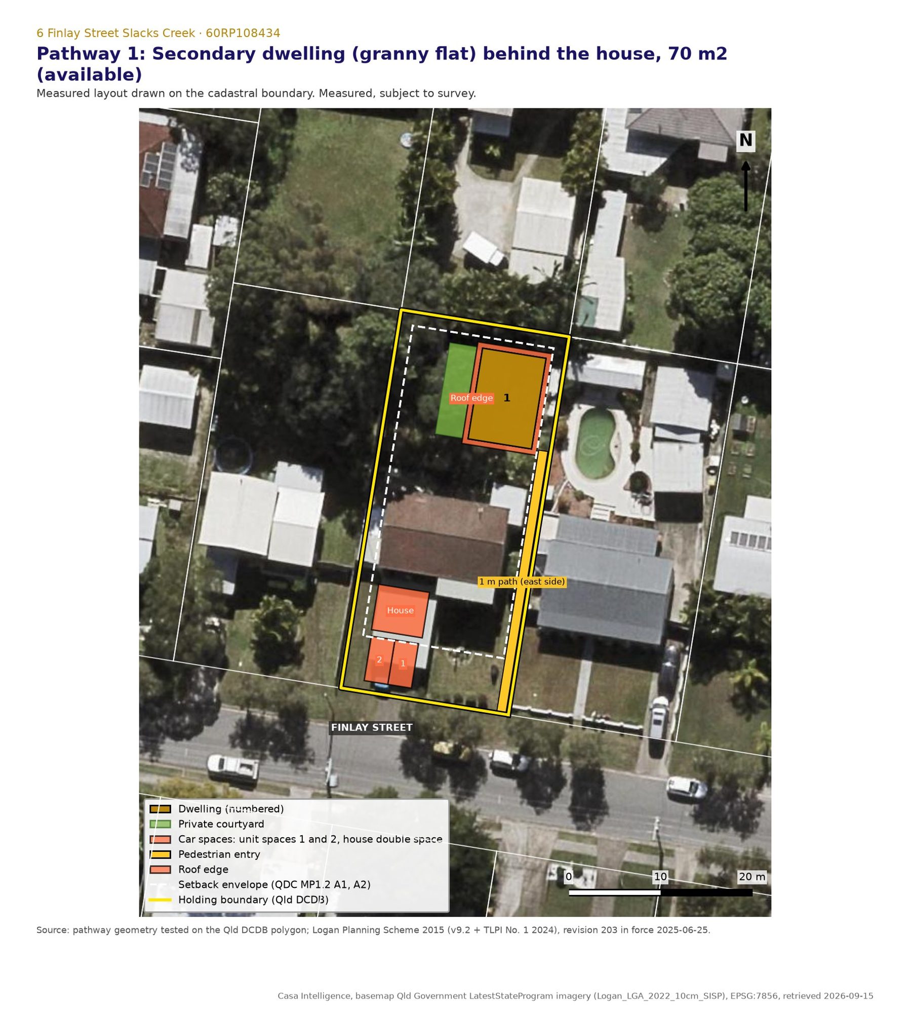
Source: pathway geometry tested on the Qld DCDB polygon; Logan Planning Scheme 2015 (v9.2 + TLPI No. 1 2024), revision 203 in force 2025-06-25.
Scope and method
What we were asked, and how we answered it
Your instruction was: "Sample report for a secondary dwelling (granny flat) on this block: the most that meets every acceptable outcome, drawn to scale, with frontage, setbacks, separation, open space, parking and access each proved against the scheme's own provisions, what council has approved nearby with any infrastructure charge quoted from a real decision notice, and the pathway. If it does not fit, say so plainly and give the AO-compliant maximum. Place it behind the existing dwelling with the setback envelope, parking and access proven."
We answered it in this order. First we took the lot's boundaries from the State digital cadastre and its ground levels from the State one metre LiDAR, then measured the frontage, the depth and the fall across the block. Next we read the planning scheme in force from Council's own electronic scheme, took the zone, the precinct and every overlay from Council's live mapping queried against the lot's own polygon, and quoted the tables of assessment and the acceptable outcomes that decide the category. We then drew the largest unit those acceptable outcomes allow, placed it behind the house, and tested each provision against the drawing: floor area, street setback, distance from the house, side and rear clearances, site cover, height, privacy, private open space, parking dimensions, the crossover rule and the fall under the footprint. Last we read Council's decision notices and delegate reports for the nearest comparable approvals, and took the infrastructure charge from a real notice Council issued.
What was not done, and is not claimed. Nobody inspected the site: the house, porch, carport and patio were digitised by eye off the 2022 10 cm State aerial with a 1 m grid in the frontage frame and are accurate to about half a metre. The title was not searched. No survey was commissioned, so every dimension in this report is measured on the cadastral polygon and the imagery and is subject to survey. No geotechnical, stormwater or services investigation was made, and no building design was prepared. The report is an assessment of record from primary sources, not a building design and not a guarantee of approval.
What is there
The site
The lot is 60RP108434, a rectangle of about 18.49 metres by 41.72 metres. The registered area is 766 square metres and the cadastral polygon computes 772.82; every scheme test in this report uses the registered area, and both figures clear the thresholds that matter. The ground rises from about 22.0 metres AHD at the footpath to 22.9 at the house, over a bank of roughly 1.4 metres, and then runs near flat at 24.33 to 24.64 metres to the rear boundary. Mean slope across the lot is 7.9 per cent, with 10.6 per cent of the surface steeper than 15 per cent, all of it on that bank. That flat rear plateau is why the unit sits where it does.
There is one house on the lot, single storey, with a roofed porch at the front eastern corner, a carport attached at the front western corner and a small roofed patio at the rear eastern corner. Together they cover about 214 square metres. One concrete crossover serves the carport. The State cadastre records no easement on the lot, and the title was not searched.
| Site particular | As read today |
|---|---|
| Lot and plan | 60RP108434 |
| Area (DCDB polygon) | 772.82 m2 |
| Area (registered) | 766.0 m2 |
| Frontage | 18.49 m to Finlay Street |
| Depth (about) | 41.72 m |
| Corner lot | no |
| Easements on the DCDB | 0 |
| Zone | Low density residential |
| Precinct | SU - Suburban |
| Local plan | none mapped |
| Ground (LiDAR) | RL 22.05 to 24.69 m AHD, mean slope 7.93% |
| Title | not searched; covenants and encumbrances unknown |
| Existing roofed area (measured from imagery) | 213.8 m2, 27.9% of the registered 766 m2 |
| Vehicle crossovers | one, at the western end of the frontage, serving the carport |
| Flood, bushfire, landslide, acid sulfate, biodiversity, waterway, noise, airport, heritage | nil: the lot is outside every one of those mapped areas |
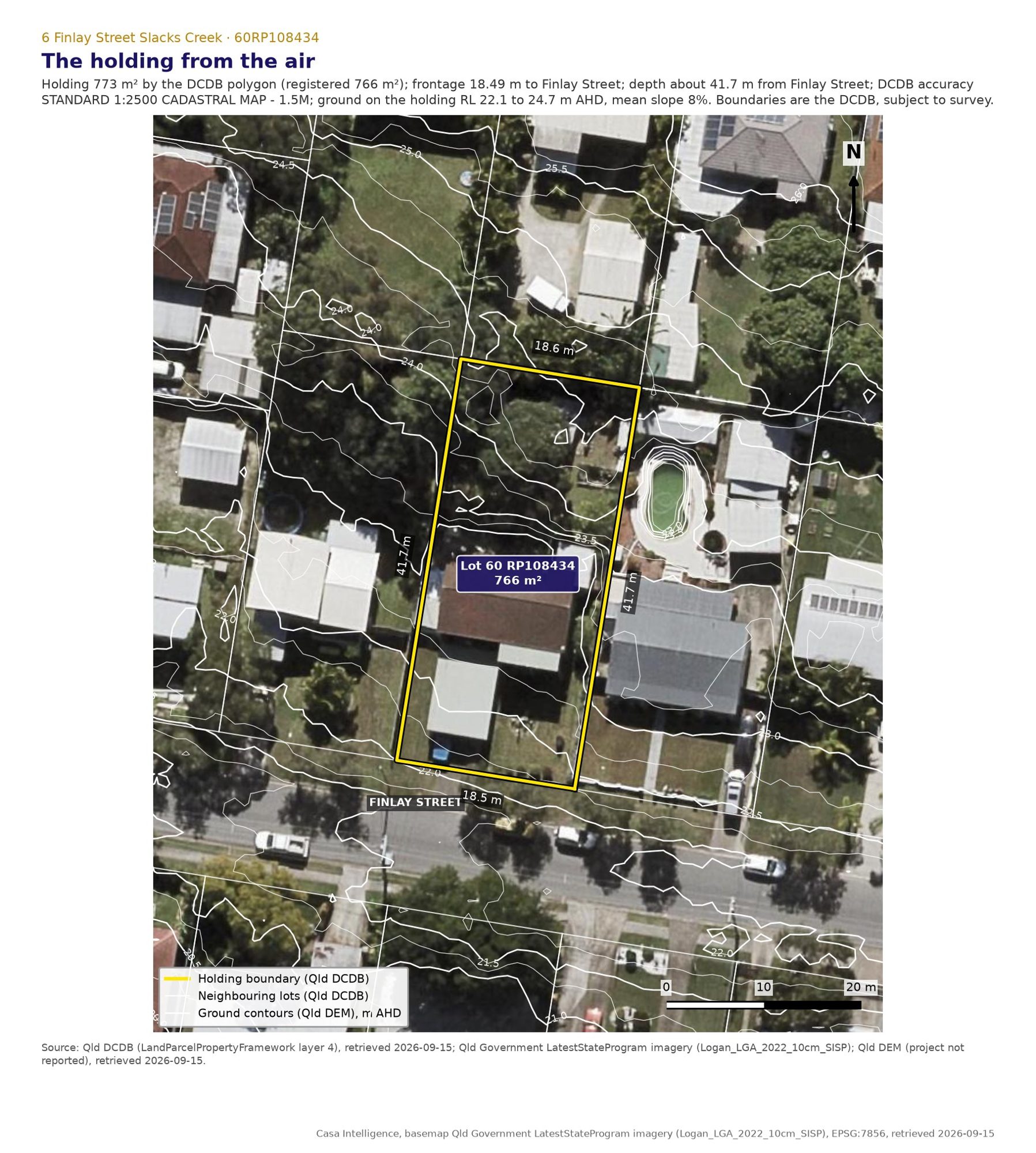
Holding 773 m² by the DCDB polygon (registered 766 m²); frontage 18.49 m to Finlay Street; depth about 41.7 m from Finlay Street; DCDB accuracy STANDARD 1:2500 CADASTRAL MAP - 1.5M; ground on the holding RL 22.1 to 24.7 m AHD, mean slope 8%. Boundaries are the DCDB, subject to survey.
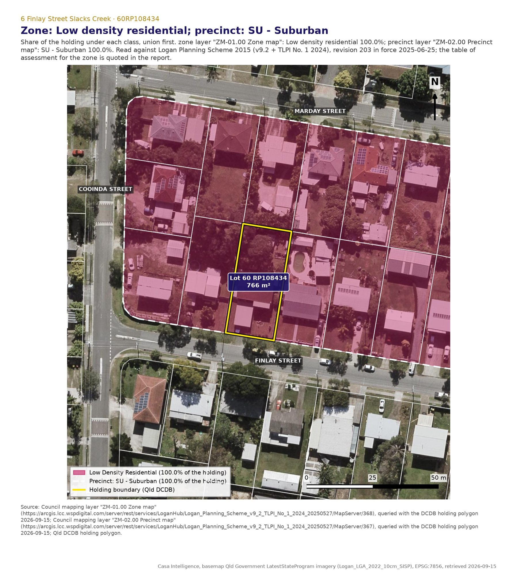
Source: Council mapping layer "ZM-01.00 Zone map" (https://arcgis.lcc.wspdigital.com/server/rest/services/LoganHub/Logan_Planning_Scheme_v9_2_TLPI_No_1_2024_20250527/MapServer/368), queried with the DCDB holding polygon 2026-09-15; Council mapping layer "ZM-02.00 Precinct map" (https://arcgis.lcc.wspdigital.com/server/rest/services/LoganHub/Logan_Planning_Scheme_v9_2_TLPI_No_1_2024_20250527/MapServer/367), queried with the DCDB holding polygon 2026-09-15; Qld DCDB holding polygon.
What governs
The framework, and the categories quoted
The instrument in force is Logan Planning Scheme 2015 (v9.2 + TLPI No. 1 2024), revision 203 in force 2025-06-25, read on 2026-09-15. There is no local plan over this land, so no local plan code applies. The zone is Low density residential and the precinct is SU - Suburban.
Three tables decide the category of assessment, and they are quoted here as they read today. The zone table, Table 5.5.5.1, says of a Dwelling house (rule 14031): "Dwelling house | Accepted development (not subject to requirements) | Editor's note - A Dwelling house becomes Accepted development (subject to requirements) where mapped in a residential area on Residential overlay map OM-10.00. The relevant assessment benchmark in section 5.10.10 is the 9.3.2 ..." The residential overlay table, Table 5.10.10.1, says (rule 23329): "Material change of use | Accepted development (subject to requirements) | If in a residential area and - for a Dwelling house; or for a class 10 building or structure for a Dwelling house. | 9.3.2 Dual occupancy and Dwelling house code" The building work table, Table 5.7.1, makes building work for the extension of a Dwelling house accepted development subject to requirements against the 9.3.2 code (rule 14412), and any other building work accepted development not subject to requirements (rule 14415); either way it is the material change of use row in Table 5.10.10.1 that holds the unit to the code, and its editor's note says (rule 14413): "Building work that does not comply with one or more of the nominated acceptable outcomes becomes code assessable development: section 5.3.3(2). For code assessable building work under this planning scheme, a development permit is required. A private certifier ..."
The consequence is set by section 5.3.3 (rule 13643): "Where nominated in the tables of assessment, accepted development must comply with the requirements identified as acceptable outcomes in the relevant parts of the applicable code(s) ... Accepted development that does not comply with one or more of the nominated acceptable outcomes in the relevant parts of the applicable code(s) ..." So the acceptable outcomes are not guidance. Meeting all of them keeps the work out of Council's hands; missing one turns that aspect into code assessable development, assessed only against the subject matter of the outcome that was missed. In practice Council receives those either as a referral agency response through the building certifier or as a code assessable application, and neither is publicly notified.
Two definitions matter. The scheme's own note says a secondary dwelling must house one household with the main dwelling, but section 1.3.1(2) gives precedence to the Planning Regulation 2017, whose Schedule 24 definition (substituted in 2022) says a secondary dwelling is one used in conjunction with but subordinate to another dwelling on the lot, "whether or not the dwelling is ... occupied by individuals who are related to, or associated with, the household of the other dwelling". Council itself sets that definition out in condition 1.3.1 of its 2025 approval at 28 Paradise Road. The unit may therefore be let to a tenant. The second definition is the floor area: the code says (rule 18957) "PO8 / AO8 Where development is a Dual occupancy (auxiliary unit) or secondary dwelling, the subordinate dwelling has a maximum gross floor area of: 70m2 if in the residential zone category and on a lot that is less than 1,000m2 in size; or ..."
Note
The pathway in one line: a secondary dwelling that meets every acceptable outcome of the 9.3.2 Dual occupancy and Dwelling house code is accepted development subject to requirements, which needs no development application to Council, only a building approval from a private certifier. Miss one acceptable outcome and that aspect alone becomes code assessable, and Council assesses it against the subject matter of the outcome missed.
Mapped constraints
The overlays, one by one
Only one overlay in Schedule 2 of the scheme touches this lot: OM-10.00 Residential overlay, which covers 100.0 per cent of the holding in the class "Residential area". It is an overlay without a code (section 8.1 rule 18172); what it does instead is change the category of assessment, taking a Dwelling house from accepted development not subject to requirements to accepted development subject to the acceptable outcomes of the 9.3.2 Dual occupancy and Dwelling house code. That single change is what makes the rest of this report necessary, and it is the benchmark every number in section 7 is tested against.
Every other overlay in the scheme was queried against the lot's polygon on Council's live mapping and returned clear: acid sulfate soils, biodiversity areas, bushfire hazard, extractive resources, flood hazard, the Greenbank training area buffer, heritage, landslide hazard and steep slope, regional infrastructure corridors and substations, strategic airport and environs, transport noise corridors, water resource catchments, and waterway corridors and wetlands. The two other mapped layers that reach the lot are figures in Council's planning scheme policies, not overlays, and they carry no table of assessment. At the State level, the trigger layers were swept as well and every one returned clear: no priority development area, no State development area, no infrastructure designation, no koala or other matter of State environmental significance, no coastal hazard, and no railway. The nearest State-controlled road, 147.5 m (BRISBANE - BEENLEIGH ROAD), is far enough away that no trigger attaches. The lot sits wholly inside the ShapingSEQ Urban footprint, which is no bar to a house or a granny flat.
One layer in the catalogue, Council's house numbers layer, returned a server error rather than a result and was not queried; the street address was confirmed from the State address register instead. Nothing in that layer changes a category of assessment.
| Mapped layer touching the lot | Class and share of the holding | What it does to the category of assessment | Table read |
|---|---|---|---|
| FIG-3.1.10.1 Ecological significance | >0 and <=12 (100.0%) | none; a planning scheme policy figure, not an overlay in Schedule 2 | not a Schedule 2 overlay: no table of assessment attaches to it |
| FIG-3.12.1 Park network planning regions | Urban (100.0%) | none for a dwelling house or its secondary dwelling | not a Schedule 2 overlay: no table of assessment attaches to it |
| Local government area | Logan City (100.0%) | none for a dwelling house or its secondary dwelling | not a Schedule 2 overlay: no table of assessment attaches to it |
| OM-10.00 Residential overlay | Residential area (100.0%) | accepted development (subject to requirements) against 9.3.2 (was not subject to requirements) | Table 5.10.10.1 (rule 23329) with Table 5.5.5.1 (rule 14031) |
| Regional land use categories (ShapingSEQ) | Urban Footprint (100.0%) | none for a dwelling house or its secondary dwelling | not a Schedule 2 overlay: no table of assessment attaches to it |
| SEQ regional land use category (ShapingSEQ 2023) | Urban footprint (100.0%) | none for a dwelling house or its secondary dwelling | not a Schedule 2 overlay: no table of assessment attaches to it |
| Suburbs | Slacks Creek (100.0%) | none for a dwelling house or its secondary dwelling | not a Schedule 2 overlay: no table of assessment attaches to it |
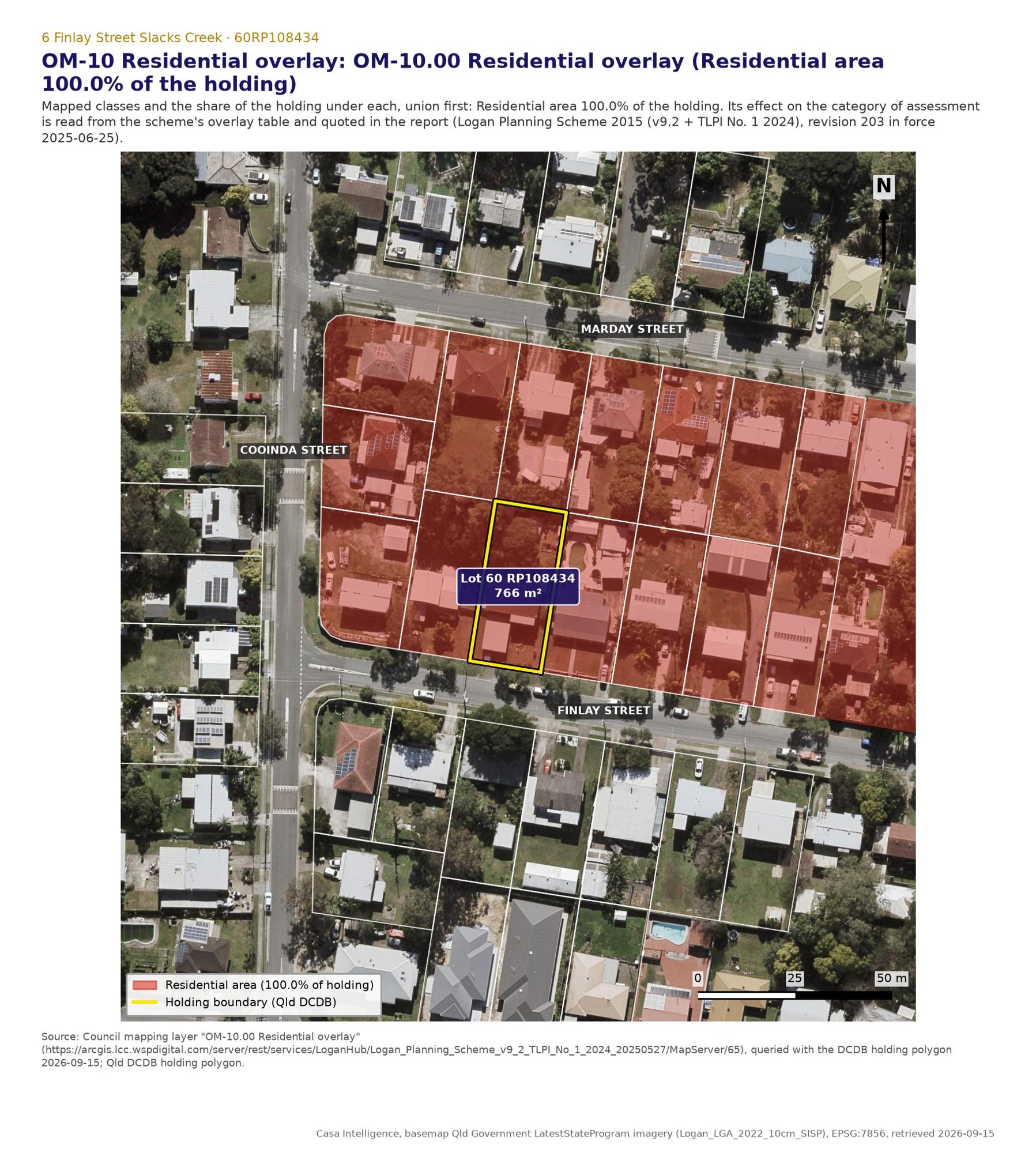
Source: Council mapping layer "OM-10.00 Residential overlay" (https://arcgis.lcc.wspdigital.com/server/rest/services/LoganHub/Logan_Planning_Scheme_v9_2_TLPI_No_1_2024_20250527/MapServer/65), queried with the DCDB holding polygon 2026-09-15; Qld DCDB holding polygon.
Hazard position
Flood, slope and the ground
The customer asked for the hazard position and it is worth stating plainly, because it is unusually clean. The lot is outside every flood area the scheme maps: it is not in the flood assessment area on OM-05.00 and not in the high, moderate or low flood risk areas or the flood investigation area on OM-05.04, which are the areas section 1.6 declares to be the designated flood hazard area. Because the lot is outside them, the flood planning levels in Table 9.3.2.3.3 do not apply and no minimum floor level is set by the scheme; the floor level of the unit is a building matter for the certifier. Council reached the same conclusion on this lot in 2014, recording in its carport approval that "the subject site is not identified as being flood affected". A flood search from Council would put that beyond doubt and is listed as a next step.
What does govern the siting here is the ground. The bank behind the house rises about 1.4 metres between 24 and 32 metres from the frontage and reaches about 17 per cent locally, which is why the unit is drawn on the plateau beyond it rather than against the house. Under the drawn footprint the ground runs 23.74 to 24.56 m AHD (range 0.82 m), mean 24.31, so the cut and fill needed to build a level floor stays below the one metre at which AO16 (rule 23998) sends retaining walls and batters to the filling and excavation standards of Planning scheme policy 5. That is a real design constraint on where the unit goes, and the drawing respects it.
Slope also settles the height rule. The lot's mean slope is 7.9 per cent, under the 15 per cent threshold, so the height solution is 8.5 metres. A single storey unit is nowhere near it.
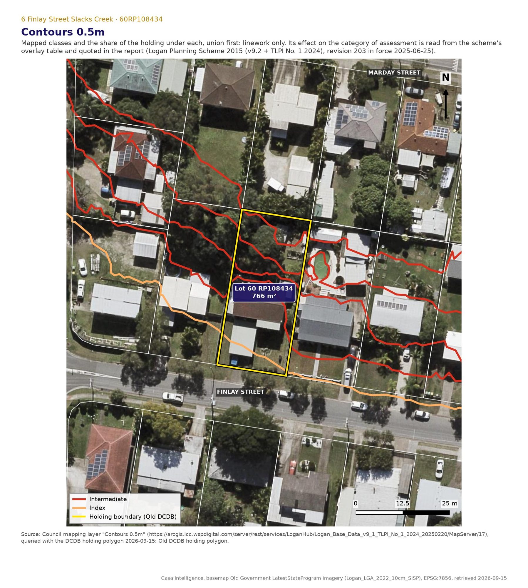
Source: Council mapping layer "Contours 0.5m" (https://arcgis.lcc.wspdigital.com/server/rest/services/LoganHub/Logan_Base_Data_v9_1_TLPI_No_1_2024_20250220/MapServer/17), queried with the DCDB holding polygon 2026-09-15; Qld DCDB holding polygon.
The granny flat
Your plan, tested outcome by outcome
The layout drawn is the maximum the acceptable outcomes allow: a detached single storey unit of 7.0 by 10.0 metres, 70 square metres of gross floor area, two bedrooms, on the flat rear plateau. Gross floor area is measured from the outside of the external walls, which is how Council writes it into its own conditions, so the 7.0 by 10.0 metres above is the outside face of the walls and the unit is drawn exactly on the cap with nothing in hand. A wall set out even 50 millimetres wider on each side puts the floor area over 70 square metres, and a unit over the cap is not accepted development at all. Ask the designer to dimension the external wall face and to hold the area at or just under 70 square metres. It stands 29.0 metres back from Finlay Street, which is more than the house; 5.0 metres clear of the rear patio and 7.5 metres clear of the main house wall, comfortably inside the 20 metre limit AO9 sets for how far a secondary dwelling may sit from the outermost projection of the house; its walls 2.13 metres off the eastern boundary and 2.72 metres off the rear, which with the 600 millimetre eaves we have assumed puts the roof edge at 1.53 and 2.12 metres, over the 1.5 metre clearance the Queensland Development Code sets for parts up to 4.5 metres high and measures to the outermost projection, which its definition says is the outside face of the fascia or any sunhood, not the wall; and 9.41 metres from the wall to the western boundary. Its own yard is 3 by 10 metres, 30 square metres, on the western side, starting at the roof edge so no part of it sits under the eave. A 1 metre path runs down the eastern side of the house from the street. Two extra car spaces sit at the front, dealt with in section 9.
Site cover is the test people most often forget, and it is the one that would have bitten a larger unit. All roofed buildings and structures on the lot may cover no more than 50 per cent of the lot. The existing house, porch, carport and patio already cover about 214 square metres, digitised at the roof edge; the unit's roof, measured to the fascia, adds 92, for 306 square metres in all, which is 39.9 per cent of the lot against the 50 per cent the solution allows (on the wall line alone the unit adds 70, for 284 square metres and 37.0 per cent). There is room, but not room for a much larger building and a shed as well.
One outcome is not proved on the drawing, and the table says so. AO18 requires the unit to connect to Council's water and sewer networks. The lot lies inside both mapped service areas, so a connection is available, but we have not located the mains, and until a services search does, that row reads not established rather than met. A main through the rear yard is also the thing most likely to move the footprint, through AO17.
70 square metres is a hard ceiling, and it is worth being exact about why. The code's acceptable outcome AO8 and its performance outcome PO8 carry the same words and the same number, so there is no performance argument that buys floor area above it on a lot under 1,000 square metres. AO8 and PO8 both state 70 square metres on a lot under 1,000 square metres, so there is no performance route; 100 square metres needs a lot of 1,000 square metres or more. The honest answer to "what is the most that fits" is therefore not a matter of geometry at all: the block has room for a bigger building, and the scheme does not allow one.
How three nearby approved applications handled the code this overlay triggers. CAR/506/2024: 57 m2 unit, four spaces drawn, two not independently usable; accepted under QDC P8 (bus stops, on-street parking, 2 bedrooms); 70 m2 GFA conditioned. At 20 Rogoff Drive, MCUR/298/2021: 0.7 m side clearance accepted under QDC P2 for a flat-roofed 2.4 m ceiling unit corner, neighbour 4.9 m away. At 9 Cooinda Street, MCUC/239/2018: 1.0 m clearances proposed, conditioned back to 1.5 m; access only via the existing driveway, widening capped at 5.0 m in the road reserve. The pattern is consistent: Council does not refuse this class of building near here, it conditions it back to the code's numbers, and where a number cannot be met it assesses the departure against the matching performance criterion. Nothing in the drawn layout needs that treatment, which is the point of drawing it to the acceptable outcomes.
| What is tested | What the provision requires | What we measured on the drawing | Result | Provision |
|---|---|---|---|---|
| GFA of the secondary dwelling | <= 70 m2 (lot < 1,000 m2) | 70.0 m2 (7.0 x 10.0 m external) | Met | 9.3.2 AO8 rule 18957 |
| Lot area band | less than 1,000 m2 | 766.0 m2 registered (772.82 polygon) | Met | 9.3.2 AO8 |
| Distance from outermost projection of the house | <= 20 m | 5.0 m (to the rear patio); 7.5 m to the main rear wall | Met | 9.3.2 AO9 rule 29626 |
| Primary street setback not less than the house | >= 9.0 m (house/porch; carport 2.9 m is a class 10 structure) | 29.0 m | Met | 9.3.2 AO9 |
| Additional crossover | none (single-frontage lot) | none: existing crossover retained | Met | 9.3.2 AO10 rule 29627 |
| Side and rear boundary clearance to the outermost projection (parts <= 4.5 m) | >= 1.5 m from the roof edge (fascia or sunhood), not the wall | east 1.53 m to the roof edge (2.13 m to the wall with 600 mm eaves, assumption A6); rear 2.12 m to the roof edge (2.72 m to the wall); west 8.81 m to the roof edge (9.41 m to the wall) | Met | QDC MP1.2 A2(a) and definition of outermost projection, via 9.3.2 AO1 rule 15170 |
| Road boundary clearance of the unit | >= 6.0 m | 29.0 m | Met | QDC MP1.2 A1(a)(i) via AO1 |
| Site cover, all roofed buildings | <= 50% of 766.0 m2 = 383 m2 | 306 m2 = 39.9% (existing 214 m2 digitised to the roof edge + unit roof 92 m2 to the fascia with 600 mm eaves; on the wall line 284 m2, 37.0%) | Met | QDC MP1.2 A3 via AO1 |
| Building height | <= 8.5 m (slope < 15%) | single storey assumed at about 4.5 m (an assumption, not a measurement); lot mean slope 7.93% | Met | QDC MP1.2 A4 via AO1 |
| Window privacy screening | only where a window is < 1.5 m from a boundary | nearest wall 2.13 m from a boundary: not engaged | Met | QDC MP1.2 A5 via AO1 |
| Covered parking for the house (rear of the existing carport) | double covered space 5 m deep by 5.5 m wide (A8(a)(i)(B)); behind the 6 m road setback | double covered space 5.6 x 5.0 m drawn in the rear of the 6.2 x 9.0 m carport (approved BWAP/34/2014), 6.8 m from the road | Met | QDC MP1.2 A8(a)(B),(b) via AO1 |
| Two additional spaces for the unit (side by side at the carport mouth, each in tandem with a house space behind it) | 2 x 4.9 x 2.6 m; tandem allowed where one space of each pair is behind the 6 m road setback; no new crossover | two uncovered spaces 2.6 x 4.9 m at 10.9 to 16.1 m from the eastern boundary, 1.2 m from the road; the house space behind each stands 6.8 m from the road; 0.4 m clear of the carport post lines (subject to survey) | Met | QDC MP1.2 A8(a)(i),(b) via AO1; CAR/506/2024 P8 fallback |
| Entry from the existing crossover (measured) | straight entry through the existing 5 m crossover, no travel outside it | the two unit spaces span 10.9 to 16.1 m from the eastern boundary and the crossover 11.0 to 16.0 m: a vehicle up to 2.4 m wide centred in either space stays within the crossover width and drives straight in, no sideways movement; the outer 0.1 m of each space lies off the digitised driveway slab over its first 1.7 m (line marking within the lot, no change to the crossover) | Met | measured on the imagery; 9.3.2 AO10 rule 29627 (no new crossover) |
| Vehicle access past the house to the rear | >= 2.5 m (QDC), 3.0 m pavement (PSP5 rear-lot access table, comparator only) | east passage 2.0 m, west passage 2.0 m: no car reaches the rear yard; parking stays at the front (measured fact, not an acceptable outcome for the unit) | Measured fact, not a test | measured: QDC MP1.2 A1(c)(ii)(B); PSP5 Table 3.4.5.1.2 |
| Pedestrian path to the unit | >= 1.0 m (assumption) | 2.0 m clear on the east side; 1.0 m path drawn | Met | assumption A5 |
| Domestic outbuildings total | <= 150 m2 | 55.8 m2 carport; no new outbuilding | Met | 9.3.2 AO7.1 rule 15164 |
| Cut and fill under the unit (retaining over 1 m triggers PSP5 3.3) | retaining <= 1.0 m without PSP5 design | 23.74 to 24.56 m AHD (range 0.82 m), mean 24.31 | Met | 9.3.2 AO16 rule 23998; DEM |
| Water and sewer connection | connect (service area) | LGIP water and sewerage service catchments cover the lot, so the lot is in the service area; the position of the mains was not established, so connection is possible but not proved | Not established | 9.3.2 AO18 rule 23677 |
| Separation from the house (NCC, assumption) | >= 1.8 m | 7.5 m to the main house, 5.0 m to the patio | Met | assumption A2 |
| Private open space (assumption) | >= 30 m2, 3.0 m minimum | 30 m2 yard 3.0 x 10.0 m on the west side of the unit, clear of the roof edge (it starts at the fascia line, 0.0 m2 under the eave; 5.8 m from the yard to the western boundary) | Met | assumption A3 |
| Canopy under the footprint (measured, not regulated) | no overlay; trees not protected on this lot | 21 m2 of the digitised canopy edge under the unit's western strip | Met | sweep: OM-02 clear |
| Visually integrated with the primary dwelling | design outcome (PO1(b)) | matching roof pitch and cladding assumed; not a numeric test | Measured fact, not a test | 9.3.2 PO1(b) rule 15170 |
| Trunk infrastructure and road connection | connected to a constructed road; outside any network on LGIP-03.00 to 08.00 | Finlay Street is a constructed road; no existing or proposed trunk water, sewer, stormwater, road, park or community facility item is mapped on the lot (Council LGIP layers queried against the polygon) | Met | 9.3.2 AO14 rule 29625 |
| Transport noise | criteria apply only within 100 m of government supported transport infrastructure | nearest State-controlled road 147.5 m, no railway within 250 m | Not engaged | 9.3.2 AO15 |
Note
The infrastructure charge. Council's Logan Charges Resolution (No.12) 2025 (adopted charges in effect from 1 September 2025) levies $26,193.40 for a dwelling with two or fewer bedrooms, and its note confirms a Dwelling house comprising a dwelling and a secondary dwelling is charged for each dwelling. The real notice Council issued for an auxiliary unit at 4 Lennox Court, Logan Central shows exactly that figure as the nett charge payable after the credit for the existing house. Council's notice makes it due when the change happens; where the only approval is a building approval, the Planning Act 2016 (section 122) makes it payable when the final inspection certificate or certificate of occupancy for the building is given. Between the levy and the payment the resolution indexes the charge on a three year PPI average (section 3.10).
Alternatives
The other pathways, tested the same way
The auxiliary unit label. The same building can be described as a Dual occupancy (auxiliary unit): both dwellings owned by the same person on one title, no more than two bedrooms, one kitchen, one living space and the same 70 square metre cap. It is accepted development subject to the same 9.3.2 code in any precinct of this zone, so the category does not improve. It adds three acceptable outcomes that do not apply to a secondary dwelling: a minimum frontage of 15 metres, which this lot meets at 18.49 metres (AO11); a minimum of five on-site car parking spaces with at least two covered, serving both dwellings, which the four spaces drawn in section 7 do not reach (AO12); and a driveway designed to section 3.4.5 of Planning scheme policy 5 (AO13). It also changes the siting standard: AO1 sends a Dwelling house and its secondary dwelling to Queensland Development Code MP 1.2, while AO2 (rule 29614) sends a Dual occupancy, auxiliary unit included, to MP 1.3. We could not obtain MP 1.3, so the layout drawn in section 7 is not proved under this label; Council assessed the auxiliary unit at 9 Cooinda Street against MP 1.3 A2 in 2018. Its only practical difference used to be that it could house a separate household. Since the Planning Regulation definition changed, a secondary dwelling can too, so there is no longer a reason to prefer the label.
A full second dwelling. A Dual occupancy that is not an auxiliary unit escapes the floor area cap altogether and is still accepted development subject to requirements here, because the precinct minimum is 700 square metres and the lot is 766, at 26.1 per ha against the 28 dwellings per hectare maximum. It is assessed against more codes: the zone code, 9.3.2 with a different Queensland Development Code part for its setbacks and site cover, and the filling, infrastructure and servicing codes, with two spaces per dwelling of which one is covered. We could not obtain that Code part, and we have not drawn a layout that satisfies it, so we do not claim this pathway works. It also inherits the access problem: a second full dwelling at the rear has no vehicle route to it. If a larger second dwelling is what you want, this is the pathway to test next, and the first two questions are that Code part's setbacks and where the cars go.
Extending the house. Building work for a Dwelling house is accepted development subject to the same code. Within the setback envelope of 531.3 square metres, and with roofed area of about 214 square metres already used against a 50 per cent cap, roughly 169 square metres of further roof is available before site cover binds. An extension and a granny flat compete for the same allowance.
Splitting the block. Not available, and the reason is in the words of the zone code rather than in any measurement we made. PO11 reads: "in the Suburban precinct: where not creating a rear lot, has a minimum size of 400m2; where creating a rear lot, has a minimum size of 500m2". AO11 states that no acceptable outcome is provided, so those minimums sit in the performance outcome itself and there is no alternative test to meet. Two lots side by side need 800 square metres and a front and rear pair 900; the lot is 766, and the 12.5 metre minimum frontage in the reconfiguring a lot code (rule 15517) cannot be met twice across 18.49 metres. Because the minimums are not met the split would be impact assessable under Table 5.6.1 (rule 14397), not code assessable.
Getting in
Access widths, parking and the crossover
Two rules govern getting a car onto and around this lot. The Queensland Development Code, applied through AO1, treats vehicular access as adequate at a minimum width of 2.5 metres, and Council's Planning scheme policy 5 sets a 3.0 metre pavement for a rear-lot driveway serving one dwelling (Table 3.4.5.1.2), the nearest published comparator for a passage of this kind. Measured off the imagery, the clear gap between the house and porch and the eastern boundary is about 2.0 metres, and between the carport and the western boundary about 2.0 metres. Neither reaches the minimum. No car can be driven past the house to the rear yard, and widening either side would mean building work on the house. That is a measured fact about the lot, not a failure of any acceptable outcome, because the code does not require a secondary dwelling to have vehicle access to its door.
So the parking goes at the front. The Queensland Development Code solution is space for two vehicles on the lot, which we have applied per dwelling as Council did at 28 Paradise Road, an uncovered space measuring 4.9 by 2.6 metres, a double covered space 5 metres deep by 5.5 metres wide, and spaces may be in tandem provided one of them is behind the road setback. The existing carport, 6.2 by 9.0 metres and 55.8 square metres, holds the house's covered pair, drawn as a double covered space of 5.6 by 5.0 metres in its rear half, 6.8 metres from the road and so behind the six metre line. The unit's two spaces are drawn as uncovered spaces of 4.9 by 2.6 metres side by side at the mouth of the carport, 1.2 metres in from the road boundary, one in front of each of the house's spaces, so each column is a tandem pair with its rear space behind the setback, which is exactly the arrangement the solution allows. We first drew the unit's pair in the gap between the porch and the carport and rejected it: that strip sits east of the crossover and a car cannot reach it without crossing the footpath, which Council's standard access condition forbids. The spaces as now drawn span 10.9 to 16.1 metres from the eastern boundary and the crossover 11.0 to 16.0 metres, so a vehicle up to 2.4 metres wide centred in either space stays inside the crossover width and drives straight in. No second crossover is created, which is what AO10 (rule 29627) requires on a lot that is neither a corner lot nor a dual road lot.
Two cautions, both survey matters. The layout needs the carport's internal width to be the 6.2 metres on the approved plan, leaving 0.4 metres between the unit's spaces and the post lines, and the crossover to be the 5 metres we measured off the imagery; the outer 0.1 metre of each unit space lies off the digitised driveway slab over its first 1.7 metres, which is line marking inside the lot, not a change to the crossover. If a certifier will not accept the two tandem pairs as the acceptable solution, the fallback is the route Council has already accepted 280 metres from here: at 28 Paradise Road it held that four spaces were drawn but two were not independently operable, referred the point to performance criterion 8, and accepted it because the unit had two bedrooms, bus stops were near and on-street parking was available. The second caution is the crossover itself: if it is ever widened, Council's standard nearby has been to cap the width in the road reserve at five metres and to require the standard drawings from Planning scheme policy 5, which apply here because the lot is over 600 square metres. Entry is straight ahead, so no turning manoeuvre is involved; we have not run a swept path model, and a traffic engineer can confirm the layout at design.
Practice
What Council has decided nearby
The table lists the applications read for this report, each from Council's own decision notice, delegate report or development conditions. Three secondary dwellings were approved within 800 metres of this lot between 2022 and 2025, a fourth at 12 Reserve Road about a kilometre away in 2020, one auxiliary unit 166 metres away in 2018, and a full dual occupancy at 11 Lovell Street in 2023. No refusal of a secondary dwelling or an auxiliary unit appears in the 300 register records we read within 2,000 metres, which is the maximum the register returned and covers decisions since 1 January 2019; two applications were withdrawn, at 20 Reign Street and 6 Audrey Street. Records beyond that cut are unchecked. Every departure approved for a secondary dwelling or an auxiliary unit near here was a boundary clearance or a parking arrangement assessed against the matching performance criterion; the dual occupancy cases went further, with a waterway corridor departure at 19 Macquarie Street and an increased density at 15 Clara Street. None of them shifted the floor area cap.
The infrastructure charge you asked to see quoted from a real decision. Council's Logan Charges Resolution (No.12) 2025, whose adopted charges took effect on 1 September 2025, levies $26,193.40 for each dwelling with two or fewer bedrooms and $36,670.70 for each dwelling with three or more, and its own note confirms that where a Dwelling house comprises two dwellings, one of which is a secondary dwelling, the charge applies to each dwelling. The notice we read is the one Council issued with its approval of an auxiliary unit at 4 Lennox Court, Logan Central: adopted charge $62,864.10, a discount of $36,670.70 for the existing house, and a nett charge payable of $26,193.40, due when the change happens. A three bedroom second dwelling attracts $36,670.70 nett instead, as Council's notice for 15 Clara Street shows. The charge is levied on the approval, so on the pathway in section 7 Council issues its notice against the building approval, and the amount is payable when the final inspection certificate or certificate of occupancy is given (Planning Act 2016 section 122) rather than with any Council application. The figure is not fixed once levied: the note under Schedule 3 Table 2 says indexation applies from the time a charge is levied to the time of payment using a three year PPI average, under the automatic increase provisions in sections 3.10 to 3.12, and applies to all levied charges.
This lot's own history is short. In 2014 Council approved a carport under the superseded 2006 scheme, sited 2.9 metres from Finlay Street in lieu of the six metres then prescribed, on the reasoning that "Alternative siting is not an option due the location of existing buildings", and conditioned it not to be enclosed without Council's further written approval. That approval is why the carport is lawful where it stands and why the report treats it as existing covered parking. No other approval is recorded on the lot, and the lawful use is a dwelling house.
| Application | Address | Distance | What was proposed | Council's decision |
|---|---|---|---|---|
| BWAP/34/2014 | 6 Finlay Street Slacks Creek | on this lot | subject lot history: carport, reduced road boundary clearance | Approved 19 February 2014 (Logan Planning Scheme 2006, Residential 600 zone, code assessable, superseded scheme) |
| CAR/506/2024 | 28 Paradise Road Slacks Creek | 280 m | Dwelling house (secondary dwelling), referral agency response | Approved 23 January 2025 (referral agency response to the building certifier) |
| MCUC/239/2018 | 9 Cooinda Street Slacks Creek | 166 m | Dual occupancy (auxiliary unit), reduced side and rear boundary clearance | Approved 22 June 2018 (development permit and preliminary approval for building work, referral response under s56) |
| MCUR/298/2021 | 20 Rogoff Drive Slacks Creek | 334 m | Dwelling house (secondary dwelling), reduced side boundary clearance | Approved 4 January 2022 |
| MCUR/23/2022 | 19 Collard Street Slacks Creek | 798 m | Dwelling house (secondary dwelling), reduced side boundary clearance | Approved 22 April 2022 |
| MCUR/99/2020 | 12 Reserve Road Slacks Creek | 1,015 m | Secondary dwelling, reduced road boundary clearance (corner lot) | Approved 9 July 2020 |
| MCUR/288/2022 | 19 Macquarie Street Woodridge | 1,339 m | Dwelling house (secondary dwelling), overlays | Approved 9 January 2023 |
| MCUR/25/2023 | 11 Lovell Street Slacks Creek | 287 m | Dual occupancy (non-auxiliary), reduced road boundary clearance, waterway overlay | Approved 5 May 2023 |
| MCUR/99/2025 | 4 Lennox Court Logan Central | about 1,900 m | Dual occupancy (auxiliary unit): infrastructure charges notice LCC/628/2025 | Approved 6 November 2025; ICN calculated 7 November 2025 |
| MCUR/62/2025 | 15 Clara Street Logan Central | 753 m | Dual occupancy (non-auxiliary), reduced rear boundary clearance, increased density: ICN LCC/097/2026 | Approved 20 November 2025; ICN calculated 24 February 2026 |
Next steps
What to do next, in order of leverage
1. Commission an identification survey. It is the cheapest thing on this list and it decides the numbers the layout depends on: the carport's internal width of 6.2 metres, the 5 metre crossover and the 2.0 metre side passage. Ask the surveyor to pick up the crossover, the carport posts, the porch and the rear patio, and to confirm the boundaries.
2. Order a Council water and sewer services search, or lodge a Dial Before You Dig enquiry, before any plan is drawn. A sewer through the rear yard engages the Queensland Development Code standard that AO17 adopts and can move the footprint. This is the single most likely thing to change the drawing.
3. Search the title. The State cadastre shows no easement, but easements, covenants, building envelopes and other registered encumbrances are only visible on the title and its registered dealings.
4. Have the unit designed to the acceptable outcomes in section 7, not near them. The floor area is measured to the outside of the external walls, and the boundary clearances are measured to the outermost projection, which means the eaves. Council examined exactly that point at 19 Collard Street, where the wall was set at 1.5 metres with only the eaves intruding, and accepted the intrusion as a minor encroachment; at 9 Cooinda Street it conditioned clearances of 1.0 metre back to 1.5 metres. Keeping the outermost projection, which means the fascia and any sunhood, at or beyond 1.5 metres from the boundary is what keeps the job with the certifier: with the 600 millimetre eave we have assumed that puts the wall at 2.13 metres on the eastern side, which is how the unit is drawn.
5. Take the building approval to a private certifier once the plans match the outcomes, and budget the infrastructure charge of $26,193.40 for a two bedroom unit, plus indexation: the resolution indexes every levied charge from the day it is levied to the day it is paid, using a three year PPI average (section 3.10), as part of that step.
6. If the certifier will not accept the two tandem pairs as the acceptable solution, do not abandon the plan. Put the parking argument to Council under performance criterion 8 through the certifier's referral, on the same facts Council accepted at 28 Paradise Road. That route is a referral response, not a public notification, and it was decided there in about two months.
7. Order a flood search from Council if a lender or an insurer asks for one. The mapping says the lot is clear and Council said so on this lot in 2014, but a search is the document a third party will want.
Risk register
What could change this answer
Nothing in this report turns on a judgement call about whether Council will like the building. It turns on measurements taken off a cadastral polygon and 2022 imagery, and on the scheme as it reads today. The table sets out what would move the answer, how likely each is on the evidence we have, and what closes it. The two that matter most are the survey and the services search, and both are inexpensive and quick.
| What could change the answer | How likely, and on what basis | Effect on the answer | How it is closed |
|---|---|---|---|
| The identification survey moves the existing buildings | Possible: the house, porch, carport and patio were digitised from 2022 imagery at about plus or minus 0.5 m | The four spaces need the carport's approved 6.2 m internal width (0.4 m to spare at the post lines) and the 5 m crossover; a narrower carport or crossover takes away the straight entry | A survey before design; if the spaces are lost, the route Council accepted at 28 Paradise Road under QDC performance criterion 8 is the fallback |
| A sewer or water main crosses the rear yard | Unknown: Council services plan not fetched; the lot sits inside the mapped water and sewerage service catchments | QDC MP 1.4 applies through AO17 and can force the unit off the main or require a build-over approval, moving the footprint | A Council water and sewer services search, or a Dial Before You Dig enquiry, before design |
| Title carries an easement, covenant or building envelope | Unknown: the title was not searched; the State cadastre records no easement on the lot | An encumbrance in the rear yard could move or prevent the unit | A title search and a read of the registered dealings before design |
| The unit is not accepted as visually integrated with the house | A design matter, not a number: PO1(b) is a performance outcome with no acceptable outcome to meet | A certifier or Council could refer the siting outcomes back for a performance assessment | Matching roof pitch, cladding and colour to the house, and keeping the unit single storey as drawn |
| Council reads QDC A8 as requiring four independently usable spaces | Possible: Council took that point at 28 Paradise Road and resolved it under performance criterion 8 | Each unit space stands in front of a house space, so neither pair is independently operable and the parking would be assessed on performance rather than accepted outright | The same performance argument Council has already accepted 280 m away for a two bedroom unit |
| The eaves or a sunhood are wider than the 600 millimetres assumed | A design matter: the clearances in section 7 are proved with the wall at 2.13 metres and the roof edge at 1.53 metres on the eastern side | Any part of the roof, fascia or a sunhood inside 1.5 metres of the side or rear boundary takes that aspect out of the acceptable solution and makes it code assessable under section 5.3.3, as Council had to assess at 19 Collard Street | Design the eave to the section 7 numbers, or move the wall further from the boundary by the extra width |
| The scheme changes before the building approval is lodged | Possible: the scheme read is revision 203, in force 2025-06-25, and the Queensland Development Code MP 1.2 copy relied on for every clearance, site cover, height, privacy and parking number in section 7 is the 16 November 2007 publication, whose currency we could not confirm | Amended acceptable outcomes could change the floor area cap, the clearances or the parking numbers | Confirm the revision in force, and the current QDC MP 1.2 publication on the Queensland Government page, on the day the building application is lodged |
Honesty layer
What this report does not cover
- Sewer and water main positions on the lot (QDC MP1.4, AO17; a sewer through the rear yard would move the footprint): Council services plan not fetched. To resolve: Council water and sewer services search (Dial Before You Dig or Council property search).
- Council flood search report: not obtained; the lot is outside every OM-05 area on the live mapping. To resolve: a flood search from Council confirms the position; not expected to change it.
- Existing building footprints and clearances: measured from 2022 imagery at about +/-0.5 m. To resolve: identification survey; the 0.4 m clearance from the unit's spaces to the carport post lines, the 5 m crossover width and the 2.0 m side passages depend on it.
- QDC MP1.3 text (duplex standard) for the non-auxiliary dual occupancy alternative: not fetched (Queensland Government site refused the client; archive copy of MP1.2 only). To resolve: fetch MP1.3 before that pathway is designed.
- QDC MP1.2 currency: the copy read is the 16 November 2007 publication (commencing 1 January 2008) from an archived Queensland Government page; the current publication was not retrievable today. To resolve: confirm no later amendment on the Queensland Government QDC page.
- Contaminated land (EMR/CLR) search: not run. To resolve: EMR/CLR search; no planning trigger for a dwelling house.
- Imagery capture date: State aerial program Logan_LGA_2022_10cm; buildings may have changed since 2022. To resolve: site inspection.
- Stamped approved plans of the nearby secondary dwellings were not rendered and measured; Council reasons were read from the decision notices instead. To resolve: render the approved site plans if a performance-outcome argument is needed.
- Swept path (B99) for the four spaces at the carport mouth: kinematic model not run. To resolve: run or have a traffic engineer confirm.
- Queensland Heritage Register: not queried; not among the State trigger layers swept. To resolve: a QHR search by address; OM-07 is clear and a 1970s house is not expected to be listed.
- The title to the lot was not searched for this report. Easements, covenants, building envelopes and any other encumbrance registered on the title are therefore unknown, and any one of them could move or prevent the building drawn here. A title search and a read of the registered dealings is the way to settle it. The lot is part of a 1970s registered plan estate; where an estate subdivision carries covenants, those covenants commonly restrict dwelling form, materials and siting and must be read before any design is prepared.
- The unit is assumed to be a single storey, two bedroom building with a wall height of about 2.7 metres and a ridge of about 4.5 metres, with roof pitch and cladding matched to the house so that it reads as visually integrated with it, which is what the performance outcome PO1(b) requires. A different form could put that outcome in issue.
- Private open space of 30 square metres with a minimum dimension of 3 metres, and a separation of 1.8 metres between buildings on the same lot, are drawn as sensible design assumptions. Neither is a number the planning scheme sets for a secondary dwelling; the separation comes from the building rules and is a matter for the certifier.
- The unit is drawn with 600 millimetre eaves on every side, and the side and rear clearances are tested to the roof edge, because the Queensland Development Code measures them to the outermost projection, which its definition says includes the outside face of the fascia and any attached sunhood. A narrower eave complies with more to spare; a wider eave, or a sunhood, must stay inside the same 1.5 metre line.
Deterministic site plan
Site Analysis Plan
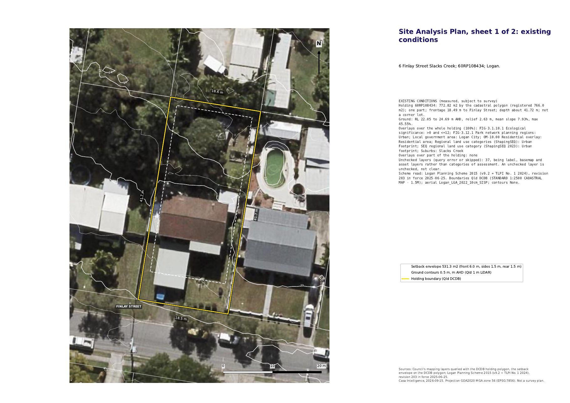
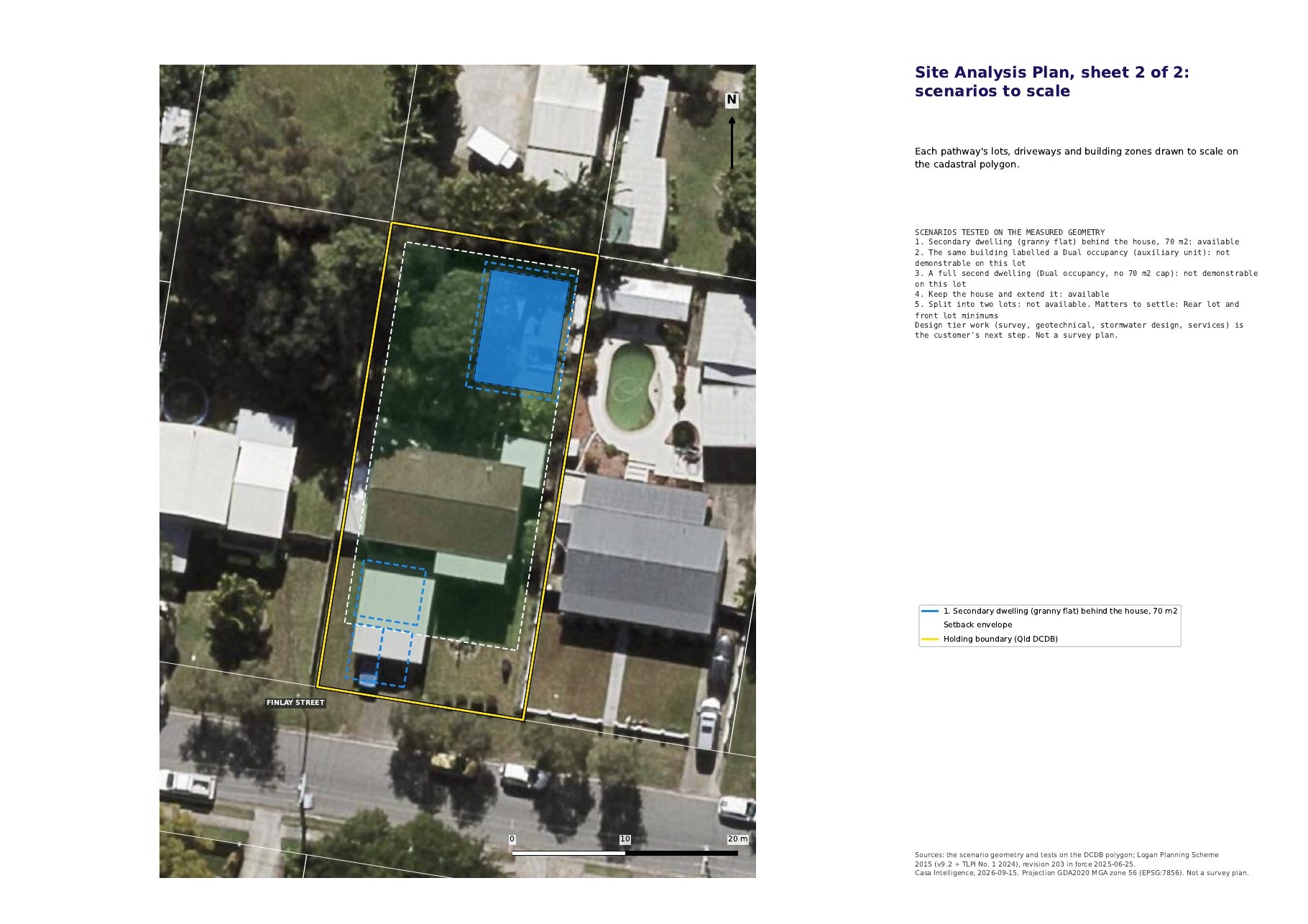
This is a real Casa Intelligence report, prepared on a real property using public planning and cadastral data. The property was selected from public listing and development-application records and we have no connection with its owner. Prepared 15 September 2026 against the planning scheme in force on that date.
Pre-delivery audit and planner pass recorded 15 September 2026. Site-constraint gate for the modelled scenario (secondary_dwelling): pass. If you are the owner of this property and would like this page removed, email hello@casaintelligence.com.au and it comes down within two business days, no questions asked.
This report is an assessment of record prepared by Casa Intelligence Pty Ltd from cited primary sources: the Logan Planning Scheme 2015 as published in Council's electronic planning scheme, Council's live overlay mapping queried against the lot's own cadastral polygon, the State digital cadastral database and LiDAR, the Planning Act 2016 and Planning Regulation 2017, the Queensland Development Code, and Council's own decision notices, delegate reports and infrastructure charges notices. It is general planning information, not planning or legal advice, and it is not a guarantee that any approval will be granted. Casa Intelligence does not act as the planner of record for any application. Categories of assessment and acceptable outcomes are stated as the instruments read on the date of issue and may change. Every dimension is measured on the cadastral polygon and on aerial imagery captured in 2022, is accurate to about half a metre, and is subject to survey. No site inspection, title search, survey, geotechnical investigation or services investigation was carried out.