Preliminary planning report
Site Possibilities
21 Regency Place Mudgeeraba QLD 4213
What this block can be used for, tested against the planning scheme in force
- Report reference
- CI-20260916-MUD
- Issued
- 2026-09-16
- Scheme in force
- Gold Coast City Plan (version 13), revision 230 in force 2025-12-02
- Prepared for
- Published as a sample
The answer
Three townhouses fit this block.
The scheme calls them a Multiple dwelling, that use is code assessable in the Medium density residential zone, and a layout of three attached two storey townhouses meets every acceptable outcome we could measure: density, site cover, all four setbacks, private open space, parking, the bin store and a 4.0 m wide common drive. The one provision it meets by performance outcome rather than by the acceptable outcome is internal circulation, because residents reverse out of their garages onto the drive (AO18.4, rule 6239). One development application to Council decides it, with no public notification and no referral agency.
Three is the ceiling, not a starting point. The Residential density overlay puts this land at one dwelling per 250 m2, and 808.73 m2 divided by 250 is 3.23. There is no acceptable outcome to fall back on for density, so the performance outcome itself has to be met. A fourth townhouse would be one dwelling per 202 m2, about 24 per cent over the map, and no decision we found nearby supports a jump of that size.
The one fact that shapes everything else is the ground and the bush behind it. The land rises about 5.2 m from the street to the rear boundary, 40 per cent of it is steeper than 1 in 7, the western 54.3 per cent sits in the Potential bushfire impact buffer and the rear corner is mapped for landslide hazard. That does not stop a townhouse development, and Council approved six dwellings as three dual occupancies on the same overlays 96 m away, but it does mean a bushfire management plan and a geotechnical report by a registered engineer go in with the application, and it drives the floor levels, the retaining and the driveway grade.
Medium density residential
Zone
3
Dwellings the scheme allows
Code assessable
Category of assessment
809 m2
Site area (registered)
Summary
You asked what the block at 21 Regency Place Mudgeeraba QLD 4213 can carry as townhouses, proved line by line against the scheme's own provisions, drawn to scale, with what Council has approved nearby and a real charge figure. This report answers that from Gold Coast City Plan (version 13), revision 230 in force 2025-12-02, from Council's own overlay mapping read against the lot boundary on 2026-09-16, from the State digital cadastre and 1 m LiDAR, and from Council's decision documents for 4 nearby applications. The measured layout is drawn at scale, and every number it turns on is set out with the provision it comes from.
- Address
- 21 Regency Place Mudgeeraba QLD 4213
- Lot / plan
- 42RP139747
- Local government
- Gold Coast
- Zone
- Medium density residential
- Site area
- 809 m²
- Overlays
- Building height 2 storeys and 9 m, Residential density RD3, 1 dwelling per 250 m2, Bushfire hazard, Potential bushfire impact buffer (54.3%), Landslide hazard (5.5%), Airport environs PANS-OPS surfaces, Dwelling house overlay area
The answer
The short answer, pathway by pathway
1. Three townhouses, your plan. A Multiple dwelling in this zone is code assessable under Table 5.5.2 (rule 6795), and neither the bushfire nor the landslide overlay table changes that: both say there is no change to the category (rules 6553 and 8865). Code assessment means no public notification, no submissions and no appeal by a neighbour, and no State referral agency applies here. On the layout we measured, every acceptable outcome that can be measured is met, with the one exception of internal circulation (AO18.4, rule 6239), which is met through its performance outcome because residents reverse out of their garages onto the drive: 3 dwellings on 808.73 m2 is one per 269.6 m2 against the one per 250 m2 map figure, site cover 195.8 m2 = 24.2%, front setback 6.0 m, sides 6.5 m and 7.0 m, rear 3.02 m, three courtyards of 52 m2 at 5.0 m wide, separation and privacy met as one attached row with obscure glazing or screens to the south facing habitable windows within 3 m of the drive (AO7.1, rule 5254), seven car spaces where six are required, and a 4.0 m formed drive. Two things are still to be settled rather than proved: an identification survey of the 20.108 m frontage against a 20 m acceptable outcome, and a traffic engineer's swept path for the car leaving the deepest garage. On the charge you asked about, three dwellings come to $93,514.35 at the published rates of the current charges resolution, before quarterly indexation and before the credit for the existing house; on the indexed rates Council actually levied next door in December 2025 the same mix would be about $101,763.20.
2. Four townhouses. Not supported. Density is the stop: four dwellings is one per 202 m2 against the mapped one per 250 m2, and the density provision has no acceptable outcome, so the performance outcome has to be met on its own terms. A fourth unit also does not fit behind the third within the rear setback, and above three dwellings the Transport code turns on a service vehicle standing area and a forward gear exit for every vehicle (rules 6347 and 6232). The route to more than three dwellings here is more land, not a better drawing.
3. Two dwellings as a dual occupancy. Available and quicker. In this zone a Dual occupancy is accepted subject to requirements, which means no development application is needed provided every required outcome is met, including the bushfire and landslide required outcomes, and a building approval is still required. If one required outcome is not met, the proposal becomes code assessable; Council's practice at 17 Sherwood Close was to assess only the outcomes not met.
4. Subdividing into two lots. Also code assessable, as a Reconfiguring a lot (5.6, rule 3213). A front lot of 312 m2 and a rear lot of about 497 m2, which is 407 m2 once the access handle is excluded, both clear the 250 m2 minimum lot size (rule 16592). This is the pattern Council approved at 17 Sherwood Close Mudgeeraba.
| Pathway | Category of assessment | Where it stands |
|---|---|---|
| Three townhouses (Multiple dwelling) | Code assessment (Table 5.5.2, rule 6795) | Fits, subject to the survey of the frontage and a traffic engineer's swept path |
| Four townhouses | Code assessment, but the density outcome is exceeded | Not supported: one dwelling per 202 m2 against one per 250 m2, and no fourth unit fits within the rear setback |
| Dual occupancy (two dwellings) | Accepted subject to requirements (Table 5.5.2, rule 6795) | Available where every required outcome is met, including bushfire and landslide |
| One lot into two (front and rear lot) | Code assessment (5.6, rule 3213) | Available, subject to the rear lot access and stormwater detail |
Note
The most this block carries as townhouses is 3 dwellings. That comes from the Residential density overlay figure of one dwelling per 250 m2 applied to 808.73 m2, which gives 3.23. Everything else in this report is built on that number.
Scope
What we were asked and how we did it
Your instruction was: "Sample report for townhouses (multiple dwellings) on this block: the most that meets every acceptable outcome, drawn to scale, with frontage, setbacks, separation, open space, parking and access each proved against the scheme's own provisions, what council has approved nearby with any infrastructure charge quoted from a real decision notice, and the pathway. If it does not fit, say so plainly and give the AO-compliant maximum. Place every unit individually to scale with separation, private open space, visitor parking and internal manoeuvring."
We answered it in this order. First the use: the scheme has no use called townhouses, so the starting point is the defined use. Three or more dwellings for separate households is a Multiple dwelling; two is a Dual occupancy. Then the instrument in force: Gold Coast City Plan (version 13), revision 230 in force 2025-12-02, read on 2026-09-16 from Council's own electronic scheme. Then the land: the lot polygon and its neighbours from the State digital cadastre, ground levels from the Queensland 1 m LiDAR, and every Council overlay layer queried against the lot boundary rather than a point. Then the categories and the benchmarks, quoted from the tables by number. Then the arithmetic and the geometry: a layout drawn on the lot polygon and tested outcome by outcome. Then Council's own decision documents for nearby applications, including the infrastructure charge notice issued next door in December 2025. Where a provision has no acceptable outcome, we say so and test the performance outcome.
What was not done, and what you would do next: no one walked the site, no title search was made, so easements and covenants registered on the title are unknown, no survey was commissioned, so the boundaries and levels are the public cadastre and LiDAR rather than a surveyor's marks, and no geotechnical or bushfire assessment was carried out. This is an assessment of record from primary sources, not a design and not a substitute for the specialist reports the application will need.
The land
The site
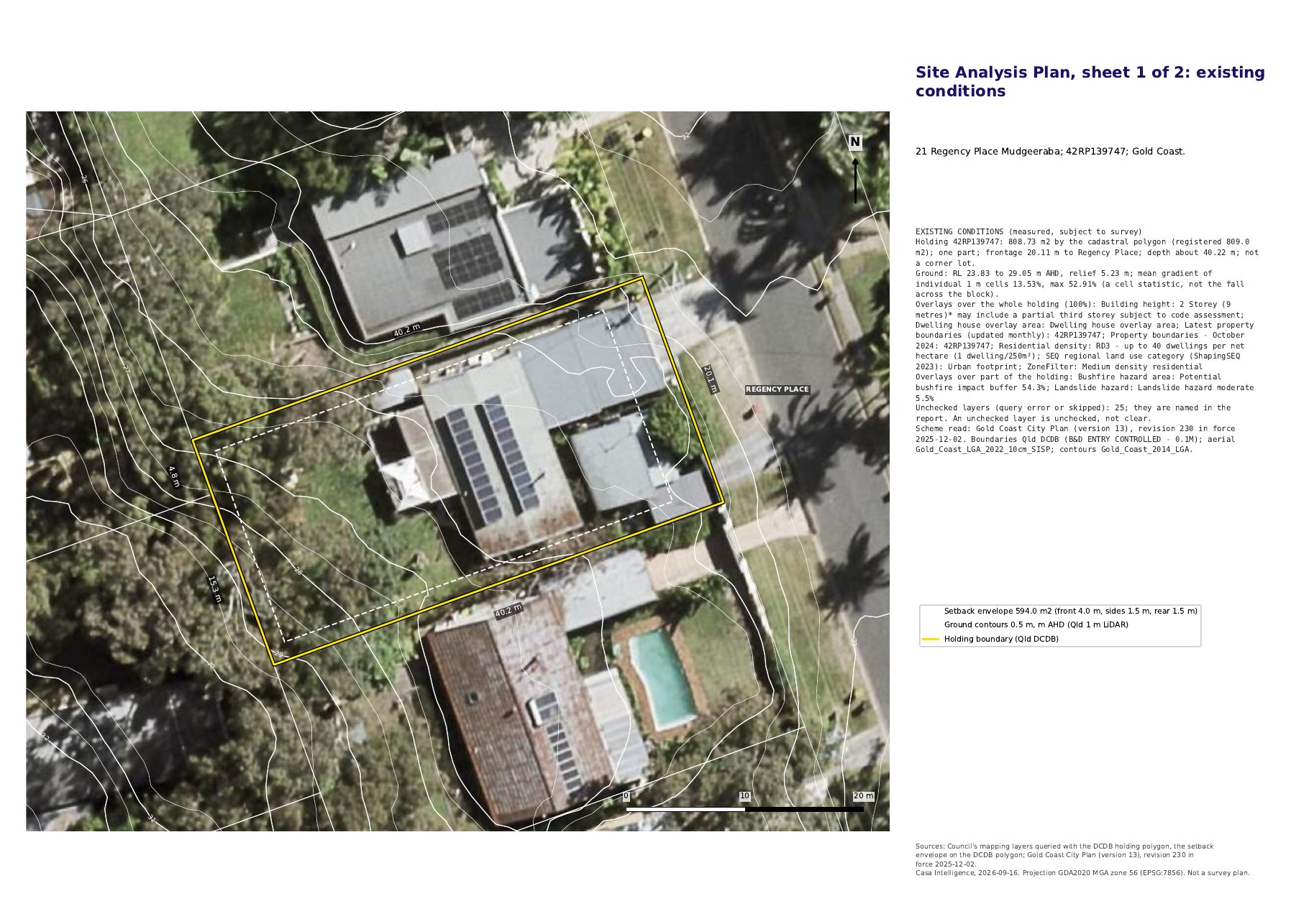
21 Regency Place Mudgeeraba QLD 4213, lot 42RP139747, is a rectangle of 809 m2 registered area (808.73 m2 by the cadastral polygon) with a single frontage of 20.11 m to Regency Place and a depth of about 40.2 m. It is not a corner lot and the cadastre records no easement over it. Regency Place is a short cul-de-sac off Sherwood Close in a small Medium density residential pocket bounded by bushland to the west (hence the bushfire buffer) and the Mudgeeraba community waste and recycling centre beyond Sherwood Close.
The land rises away from the street. Along the centre line the ground goes from RL 24.63 m at the front boundary to RL 28.56 m at the rear. The highest ground inside the lot measures RL 29.05 m on the 1 m grid, near the south west corner, and the lowest RL 23.83 m at the street, while the boundary line itself samples RL 29.25 m at that corner and RL 23.54 m at the northern end of the frontage. Mean slope is 13.5 per cent and 39.6 per cent of the lot is steeper than 15 per cent. The front 25 m, where the buildings go, rises about 1.7 m; the rear 15 m rises a further 2.3 m and carries the mature canopy that the bushfire mapping follows. An existing concrete crossover sits in the northern part of the frontage and serves the present carport.
Nil results are results. There is no flood mapping, no heritage listing, no character overlay, no ridges and significant hills mapping, no road widening, no acid sulfate soils, no wetland or waterway, no koala habitat, no matter of State environmental significance and no State controlled road frontage on this lot: the nearest State controlled road is 152.7 m (GOLD COAST - SPRINGBROOK ROAD).
| Particular | What the record shows |
|---|---|
| Lot and plan | 42RP139747 |
| Area (DCDB polygon) | 808.73 m2 |
| Area (registered) | 809.0 m2 |
| Frontage | 20.11 m to Regency Place |
| Depth (about) | 40.22 m |
| Corner lot | no |
| Easements on the DCDB | 0 |
| Zone | Medium density residential (100% of the lot on Council's zone layer) |
| Precinct | none mapped |
| Local plan | none mapped |
| Ground (LiDAR) | RL 23.83 to 29.05 m AHD, mean slope 13.53% |
| Title | not searched; covenants and encumbrances unknown |
| Adjoining zoning | every adjoining lot Medium density residential |
| Services | Inside Council's existing water and sewer connection areas and the priority infrastructure area |
| Flood | No flood layer applies to this lot; the land sits between RL 23.8 and 29.1 m AHD on a hillside |
| Existing use | One dwelling house with a carport and an outbuilding; two building approvals on the lot and no material change of use approval |
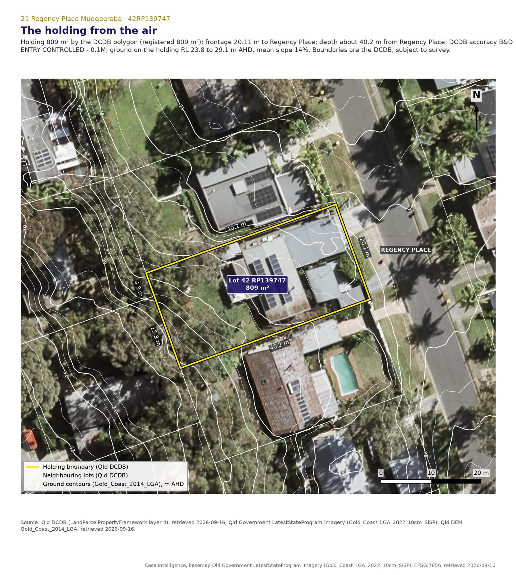
Holding 809 m² by the DCDB polygon (registered 809 m²); frontage 20.11 m to Regency Place; depth about 40.2 m from Regency Place; DCDB accuracy B&D ENTRY CONTROLLED - 0.1M; ground on the holding RL 23.8 to 29.1 m AHD, mean slope 14%. Boundaries are the DCDB, subject to survey.
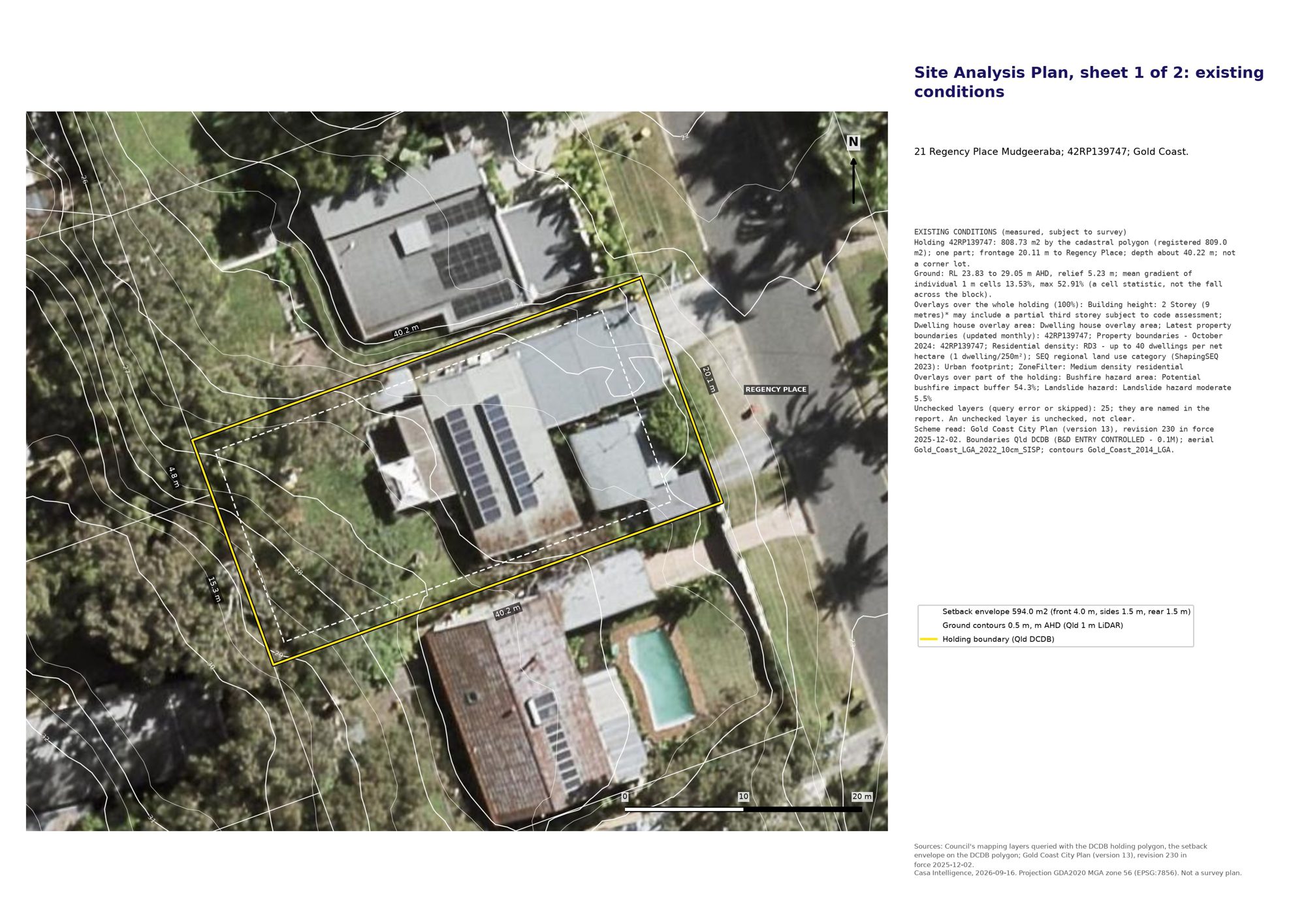
Council mapping layers and the DCDB
The rules
The framework and the categories, quoted
The instrument in force is Gold Coast City Plan (version 13), revision 230 in force 2025-12-02. There is no local plan and no precinct here: Part 7 of the scheme states that there are no local plans in the City Plan (rule 17965), and Council's zone layer records no precinct for this lot. There is no priority development area, no State development area, no temporary local planning instrument and no master plan or approved plan of development over the land. The lot is inside the ShapingSEQ 2023 Urban Footprint, which places no constraint on urban residential use.
The zone is Medium density residential across 100 per cent of the lot, and so is every adjoining lot, so no lower density transition applies. Table 5.5.2 makes a Multiple dwelling code assessable (rule 6795), a Dual occupancy accepted subject to requirements, and building work for a partial third storey within the mapped 9 m code assessable (rule 6799). Reconfiguring a lot is code assessable (5.6, rule 3213). The scheme's own order of operations is set out at 5.3.1 (rule 3185): establish the use, identify the zone, identify the overlays, check the Planning Regulation, take the category from the zone table, then check the overlay tables to see whether any of them changes it. Section 5.3.2 (rule 3192) adds that where only part of the land is affected by an overlay, the overlay's category applies to that part, and the highest category prevails.
Two provisions carry no acceptable outcome, and where the scheme provides none, 5.3.3 (rule 3197) requires the performance outcome itself to be met. They are density (PO5, rule 16588), which ties dwellings to the Residential density overlay figure, and height (PO3, rule 16584), which ties built form to the Building height overlay figure of 2 storeys and 9 m. The measurable benchmarks come from the zone code (setbacks AO1, rule 16559; site cover AO2, rule 16582; minimum lot size AO7.1, rule 16592), the Multiple accommodation code (frontage AO1, rule 5240; orientation AO3.1, rule 5243; privacy AO7.1, rule 5254; private open space AO8, rule 5260; communal open space AO9.2, rule 5264; articulation AO10, rule 5269), the Transport code (parking rates in Table 9.4.13-3, rule 23453, with the rounding rule 6244 and visitor spaces at rule 6208), the Driveways and vehicle crossings code (rules 5748 and 5750), the Solid waste management code with policy SC6.16 (rule 6863), the Healthy waters code, the Fire services code (rule 5759), the General development provisions code and the Vegetation management code. The overall outcomes of the zone code at 6.2.2.2(b) are the yardstick if any performance outcome has to be argued, and that is exactly the path Council took next door.
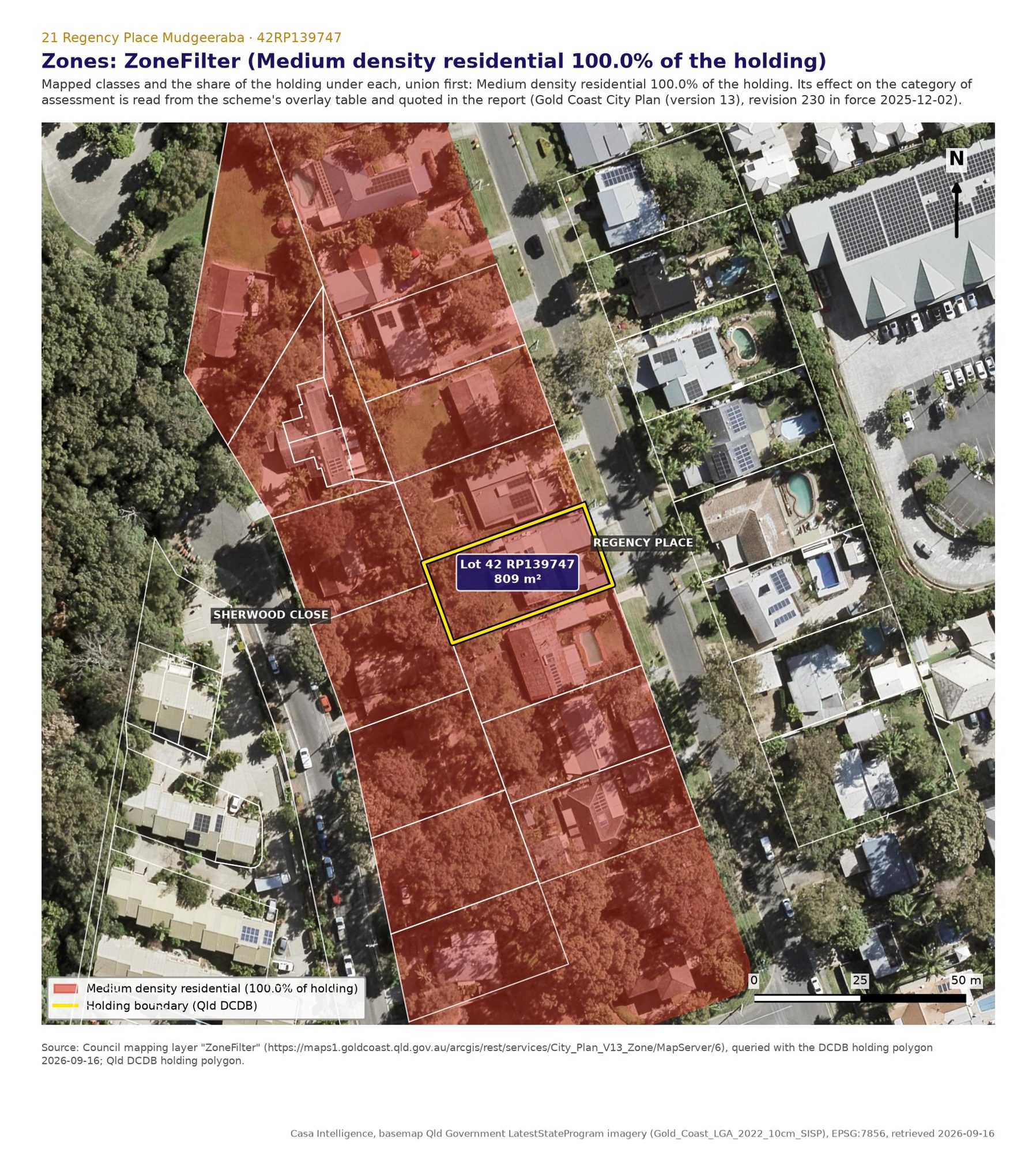
Source: Council mapping layer "ZoneFilter" (https://maps1.goldcoast.qld.gov.au/arcgis/rest/services/City_Plan_V13_Zone/MapServer/6), queried with the DCDB holding polygon 2026-09-16; Qld DCDB holding polygon.
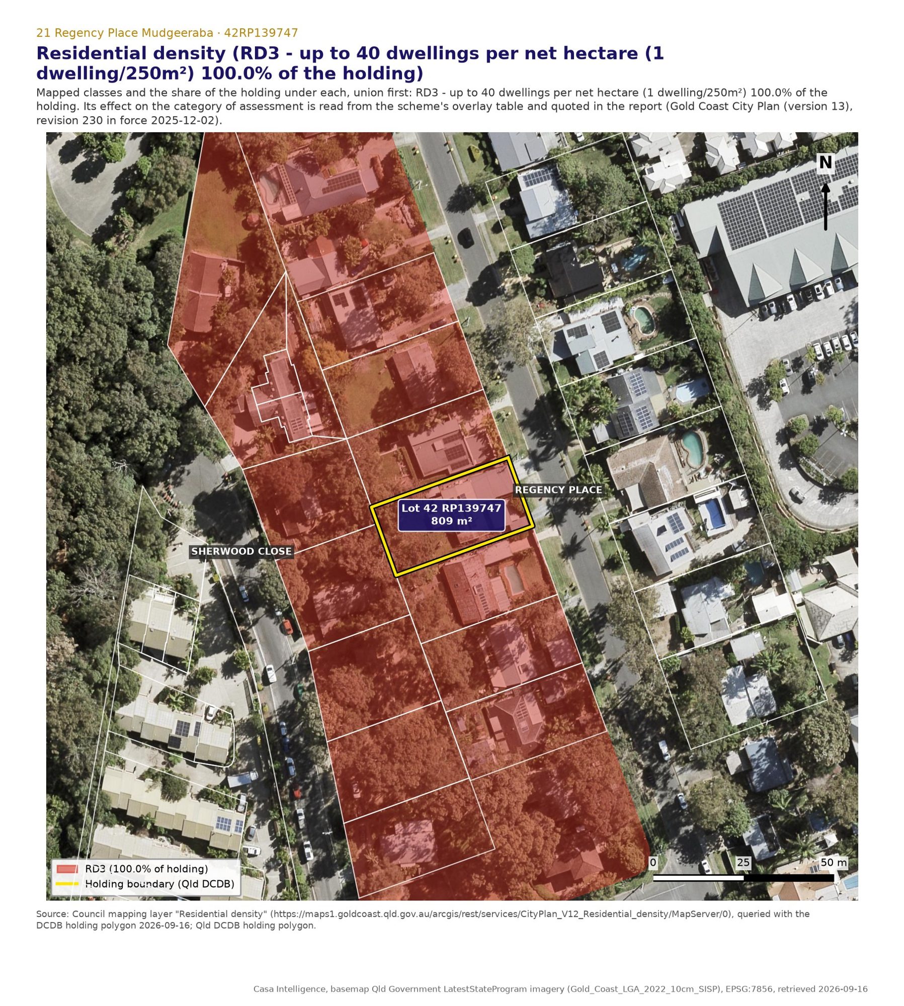
Source: Council mapping layer "Residential density" (https://maps1.goldcoast.qld.gov.au/arcgis/rest/services/CityPlan_V12_Residential_density/MapServer/0), queried with the DCDB holding polygon 2026-09-16; Qld DCDB holding polygon.
Constraints
The overlays, one by one
Every Council overlay layer was queried with the lot polygon, not a point, and the share of the lot under each class was measured after the features of that class were merged. Six overlays touch this land and only two of them change what you have to do.
Building height covers the whole lot at 2 storeys and 9 m. Residential density covers the whole lot at RD3. The Potential bushfire impact buffer covers 54.3 per cent, 439 m2, being the western or rear half of the lot. Landslide hazard covers 5.5 per cent, 45 m2, in the north west rear corner, and because the landslide code applies to any lot that is partially or completely mapped, its requirements attach to the whole development, not just that corner. The PANS-OPS airport surface layer covers the whole of this lot as a single polygon, and it changes the category only if a building intrudes into the height limitation surface (Table 5.10.2, rule 6539). The layer carries no surface height and the table gives none, so the level of that surface was not read; it is a question for the pre lodgement meeting, and a building held to the 9 m the Building height overlay allows does not change the category unless it intrudes. The Dwelling house overlay applies to houses only and is irrelevant to a Multiple dwelling.
The important point for your plan is that neither hazard overlay changes the category of assessment. Table 5.10.3 (rule 6553) and Table 5.10.14 (rule 8865) both record no change for a material change of use. What they change is the evidence: a bushfire management plan prepared to planning scheme policy SC6.3, and a geotechnical stability assessment by a registered professional engineer of Queensland to policy SC6.10, with retaining walls certified and cut or fill kept to 1.2 m at a residential boundary unless it is terraced (AO3.1, rule 3996).
| Overlay and class | Share of the lot | What it does to this proposal | Where that comes from |
|---|---|---|---|
| Building height overlay (2 Storey (9 metres)* may include a partial third storey subject to code assessment) | 100.0% of the lot | RO3/PO3 MDR zone code: 2 storeys and 9 m | Table 5.5.2 rule 6799 |
| Residential density overlay (RD3 up to 40 dwellings per net hectare (1 dwelling/250m2)) | 100.0% of the lot | PO5 (no AO): density does not exceed the map: 808.73/250 = 3.23, so 3 dwellings | 6.2.2 rule 16588, 16592 |
| Bushfire hazard overlay (Potential bushfire impact buffer) | 54.3% of the lot (439 m2) | Table 5.10.3 rule 6553: MCU n.e.i 'No change to the categories of development and assessment', Bushfire hazard overlay code applies as a benchmark | 8.2.3 rules 3387-3406 |
| Landslide hazard overlay (Landslide hazard (moderate per Council's coverage class)) | 5.5% of the lot (45 m2) | Table 5.10.14 rule 8865: MCU n.e.i 'No change' | 8.2.11 rules 3986-4001 |
| Airport environs: PANS-OPS surfaces (PANS-OPS contour polygon covering the lot; surface level not read) | 100.0% of the lot | Table 5.10.2 rule 6539: code assessment only if the building intrudes into the height limitation | Table 5.10.2 |
| Dwelling house overlay area (Dwelling house overlay area) | 100.0% of the lot | applies to Dwelling houses only (Table 5.10.5): a partial third storey house becomes code assessable | Table 5.10.5 rule 6570 |
| Mudgeeraba Village character overlay | checked, nothing mapped | not applicable; nothing of the Mudgeeraba Village character overlay code (8.2.13) applies to this lot | Council layer queried by polygon |
| Flood, heritage, ridges and significant hills, road widening, State controlled road and transport noise, minimum lot size, party house, environmental significance, acid sulfate soils, coastal erosion, extractive resources, water catchments, industry and community infrastructure interface areas (including the waste and recycling centre interface) | checked, nothing mapped | No effect on this land | Council layers queried by polygon |
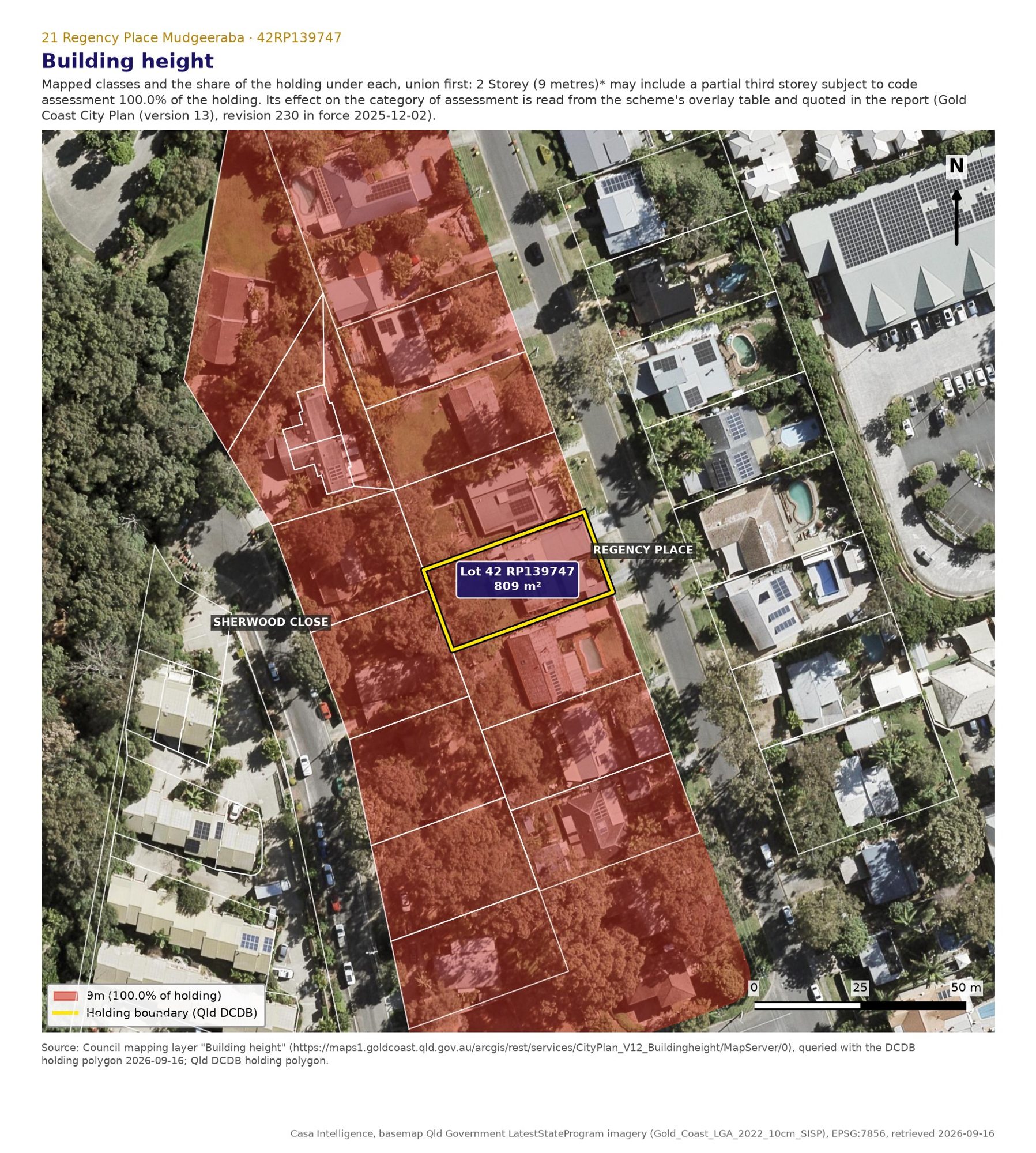
Source: Council mapping layer "Building height" (https://maps1.goldcoast.qld.gov.au/arcgis/rest/services/CityPlan_V12_Buildingheight/MapServer/0), queried with the DCDB holding polygon 2026-09-16; Qld DCDB holding polygon.
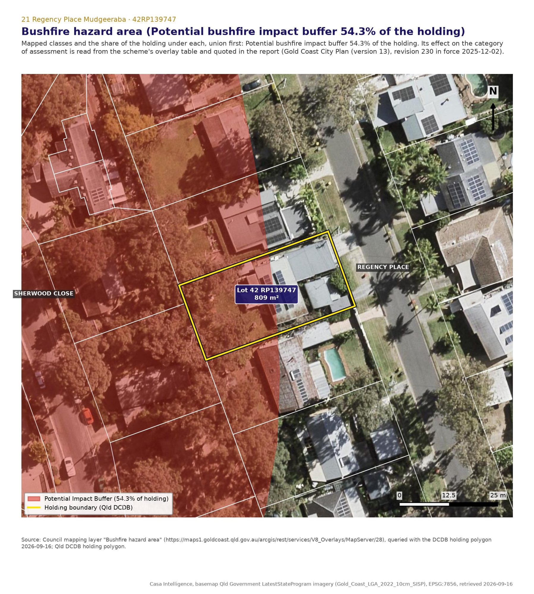
Source: Council mapping layer "Bushfire hazard area" (https://maps1.goldcoast.qld.gov.au/arcgis/rest/services/V8_Overlays/MapServer/28), queried with the DCDB holding polygon 2026-09-16; Qld DCDB holding polygon.
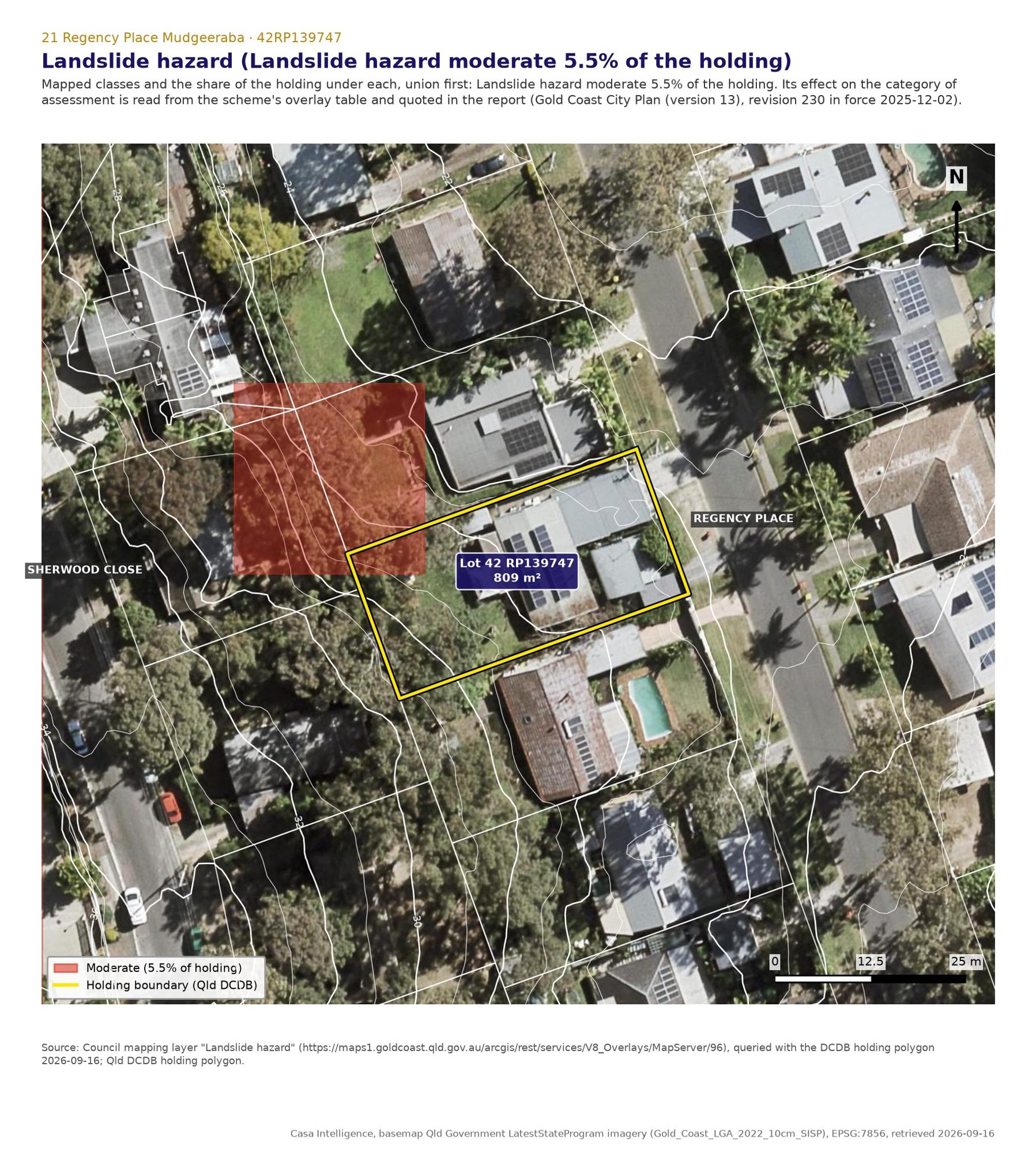
Source: Council mapping layer "Landslide hazard" (https://maps1.goldcoast.qld.gov.au/arcgis/rest/services/V8_Overlays/MapServer/96), queried with the DCDB holding polygon 2026-09-16; Qld DCDB holding polygon.
The governing hazard
Slope, bushfire and landslide: the hazards that govern here
There is no flood on this land, so the hazards that govern are the slope and the bush behind it. Levels come from the Queensland 1 m LiDAR flown in 2014, not from a survey. Across the lot the ground rises 5.23 m, from RL 23.83 m at the street to RL 29.05 m at the rear on the 1 m grid. The frontage itself rises from RL 23.54 m at its northern end to RL 24.67 m at its southern end across its 20.11 m, with a high point of about RL 25.0 m along it. The southern boundary, where the drive runs, climbs from RL 24.67 m at the street to RL 29.25 m at the rear corner; that figure is sampled on the boundary line itself, which straddles the neighbour's ground, and the highest 1 m cell inside the lot reads RL 29.05 m.
Those numbers set three things. First the driveway: on the natural surface the drive climbs from RL 24.65 m at the street to RL 28.50 m at unit 3, an average of 10.4 per cent with 1 m steps as steep as 39 per cent. RO3 (rule 3390) sets 12.5 per cent as a maximum, not an average, so the drive has to be cut and graded to hold it rather than follow the ground, and the earthworks drawings are what prove it. Second the floors: the ground under each unit footprint moves between 0.68 m and 1.52 m, so the floor levels will step with the ground or the ground will be retained, with cut or fill kept under the 1.2 m the landslide code allows at a residential boundary (AO3.1, rule 3996); how is a design matter. Third the courtyards: each falls about 1.0 to 1.3 m across its length, so each is terraced to hold the 1 in 10 maximum grade the private open space outcome requires.
How Council has handled this nearby. At 17 Sherwood Close Mudgeeraba, 96 m away and on the same two overlays, the officer recorded that the applicant provided a written bushfire report identifying the site in a bushfire hazard area and that the bushfire management plan "outlines specific recommendations and requirements to effectively mitigated bushfire hazard" and "has been conditioned in the development permit". On the geotechnical side the officer wrote that the site has "several mapped constraints, specifically landslide and bushfire hazard" and that "specialist reports have been prepared by RPEQ's that effectively respond to these hazards". The approval carried conditions for geotechnical certification and supervision, a slope sensitive lots property notification, bushfire certification before the building work is finished, and retaining walls with the landscaping works. That is the evidence package this site should expect to lodge.
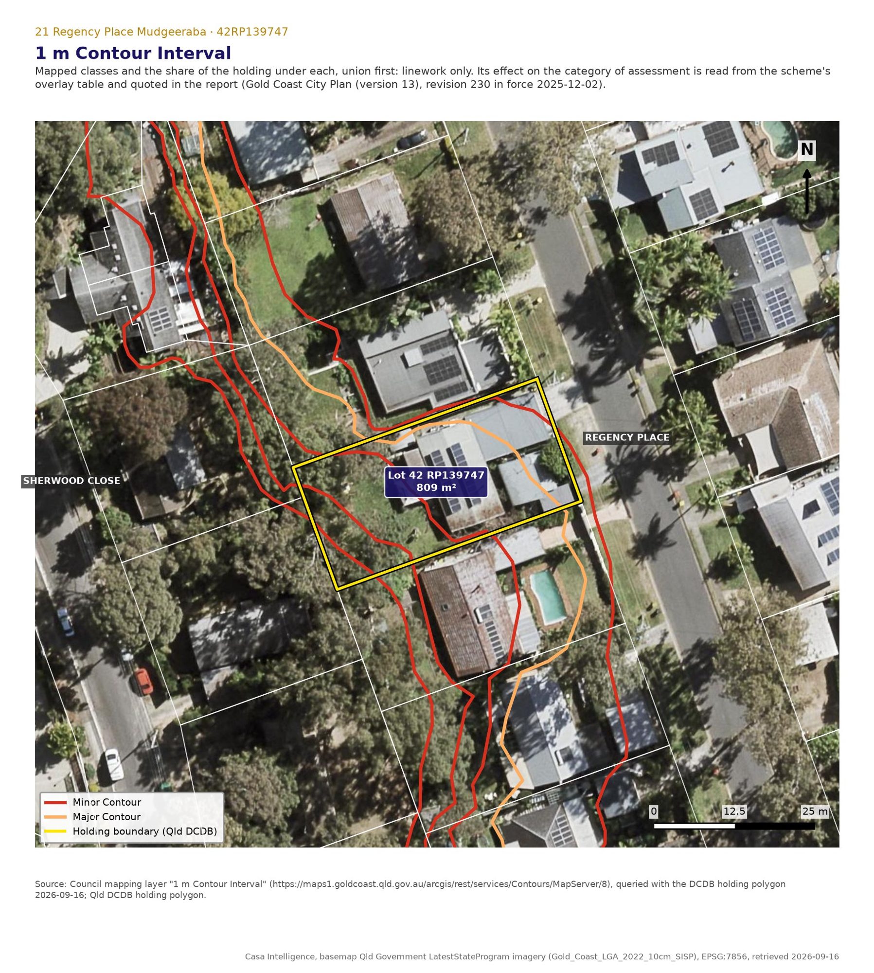
Source: Council mapping layer "1 m Contour Interval" (https://maps1.goldcoast.qld.gov.au/arcgis/rest/services/Contours/MapServer/8), queried with the DCDB holding polygon 2026-09-16; Qld DCDB holding polygon.
Your plan
Three townhouses, tested against every acceptable outcome
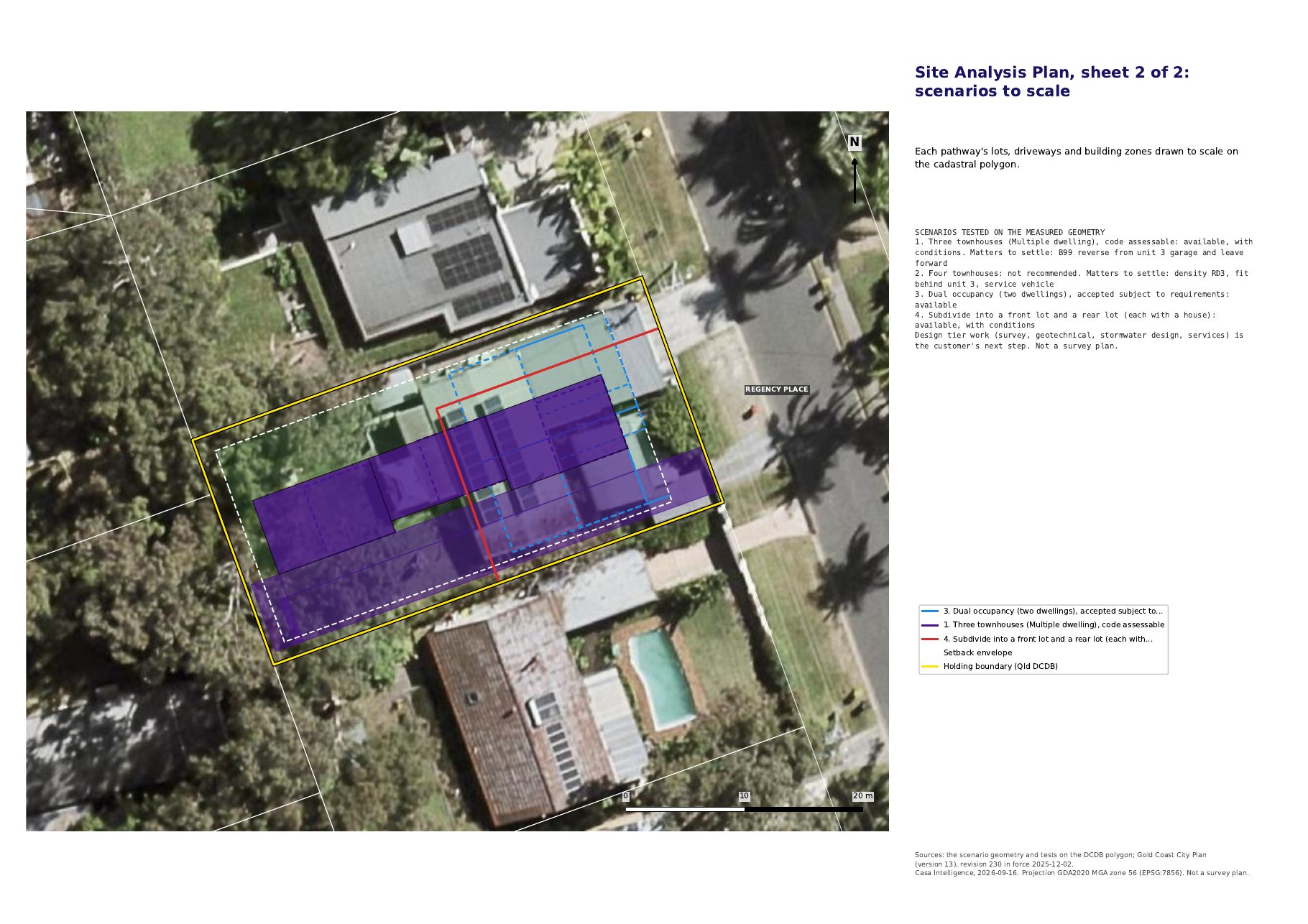
The layout tested is three attached two storey townhouses in a row along the northern side of the lot, with a 4.0 m common drive down the southern boundary, a double garage to each unit opening onto that drive, north facing courtyards of 52 m2 behind each unit, one visitor space and a bin store near the street, and bioretention at the low corner. Units 1 and 3 are three bedroom at about 69 m2 of footprint each, unit 2 is two bedroom at about 58 m2 with its wall offset 1 m so that no more than two walls sit in the same plane. Site cover is 195.8 m2 = 24.2%, well under the 50 per cent the zone code allows, which is what leaves room for courtyards and deep planting on a sloping lot.
Every measurable acceptable outcome is met on that layout, as the table sets out, with one exception that no garage and drive townhouse layout meets literally: AO18.4 of the Transport code (rule 6239) asks that all vehicles circulate on site in a forward gear without reverse manoeuvres, and residents here reverse out of their garages onto the common drive. That relies on the performance outcome, PO18, which asks for continuous circulation so that the road network is not used to reach parts of the site, and every vehicle still leaves to the street in forward gear. The code's own note that a forward gear exit is not required at three dwellings sits on PO14 (rule 6232), not on AO18.4. Two matters sit above the measuring. The first is orientation: the Multiple accommodation code asks that development address the street, and on a single frontage lot only the front unit can. The rear two address the common drive, which is the performance outcome route, and it is the arrangement Council accepted for the rear dwellings at 17 Sherwood Close Mudgeeraba. The second is privacy and separation. AO7.1 (rule 5254) has two limbs: a habitable room window must not directly face a habitable room window of another building within 10 m, or an access way, footpath or communal open space within 3 m, unless the window has fixed obscure glazing below 1.5 m above floor level or a privacy screen over at least half the window view. On this layout the 3 m limb is the one engaged, because any south facing habitable window sits within 3 m of the common drive and takes obscure glazing or a screen. The 10 m limb runs to the windows of the houses either side, and their window positions were not surveyed, so it is proved on the drawings; the 6.5 m and 7.0 m side setbacks leave room for it. Both are details for the drawings rather than a constraint on the yield.
What Council has approved nearby on the overlay this triggers. COM/2024/203 at 17 Sherwood Close Mudgeeraba, 96 m from your block, is the closest decision in the same zone with the same two hazard overlays: Combined ROL 1 into 3 lots (487, 380, 613 m2 incl. access easement) and MCU Dual occupancy x 3 (6 dwellings), approved with conditions on 17 December 2025. Council accepted a density of one dwelling per 246.83 m2 against the same RD3 map figure, that is a small overshoot argued against the zone's overall outcomes, and accepted setback encroachments because, in the officer's words, they "predominantly result from outer-most projections, or corners of the building, where the majority of the wall plane remains compliant with the Acceptable outcome". The scheme tested here needs neither of those arguments: it sits inside the density map figure and inside every setback. MCU/2021/244 at 69 Railway Street Mudgeeraba, 530 m away, is the nearest decided townhouse form Multiple dwelling: Multiple dwellings (5 units: three 2-storey attached townhouses and two single storey units on a podium) with an existing Food and drink outlet, approved in 2021 at 2 storeys and 8.8 m with private open space of 35.5 m2 per townhouse, less than the 52 m2 drawn here.
The charge. Under the Council of the City of Gold Coast Charges Resolution (No. 1) of 2025 the residential rates are $34,452.65 for each dwelling with three or more bedrooms and $24,609.05 for each dwelling with two bedrooms or fewer. Two three bedroom units and one two bedroom unit come to $93,514.35 before quarterly indexation and before the credit for the existing lawful dwelling, which is deducted under clause 3. Those are the published base rates; the rates actually levied next door are higher because of indexation. The infrastructure charges notice issued for COM/2024/203 on 18 December 2025 levied "Residential uses 2 bedroom" at 4 dwellings and a rate of $26,779.82, giving $107,119.28, and "Residential uses 3+ bedroom" at 2 dwellings and a rate of $37,491.69, giving $74,983.38, a "Total levied charge payable" of $182,102.66 for six dwellings. On those indexed rates the same three unit mix would be about $101,763.20 before the credit.
| What is tested | What the scheme asks | What the layout measures | Result |
|---|---|---|---|
| Density (PO5, rule 16588, no acceptable outcome) | 1 dwelling per 250 m2 (RD3 on the overlay map) | 3 dwellings on 808.7 m2 = 1 per 269.6 m2 | Meets |
| Road frontage (AO1, rule 5240) | >= 20 m | 20.108 m from the cadastre | Meets, by 0.1 m, survey needed |
| Site cover (AO2, rule 16582) | <= 50% of net site area | 195.8 m2 = 24.2% | Meets |
| Front setback (AO1, rule 16559) | 4 m to walls, 6 m to covered parking | 6.0 m to both | Meets |
| Side setbacks (AO1, rule 16559) | 1.5 m to 4.5 m wall height, 2 m between 4.5 m and 7.5 m, plus 0.5 m for every 3 m over 7.5 m | 6.5 m north, 7.0 m south | Meets |
| Rear setback (AO1, rule 16559) | 1.5 m to 4.5 m wall height, 2 m between 4.5 m and 7.5 m, plus 0.5 m for every 3 m over 7.5 m | 3.02 m | Meets |
| Height (PO3, rule 16584, no acceptable outcome) | 2 storeys and 9 m from the overlay map | Two storey module, ridge under 9 m | Meets on the design assumption |
| Private open space (AO8, rule 5260) | >= 25 m2, >= 5 m wide, no steeper than 1 in 10 | 52 m2 each at 5.00 m wide, terraced | Meets |
| Articulation (AO10, rule 5269) | No more than two walls in one plane unless offset 1 m; no more than four attached | Middle unit offset 1 m, three attached | Meets |
| Privacy and separation (AO7.1, rule 5254) | No habitable room window directly facing another within 10 m or an access way within 3 m, or obscure glazing below 1.5 m / a 50 per cent privacy screen | Attached row, one frontage: the 3 m drive limb is engaged, obscure glazing or screens to south facing habitable windows; neighbours' window positions not surveyed | Meets on the design assumption |
| Communal open space (AO9.2, rule 5264) | Required at ten or more dwellings | Three dwellings | Does not apply |
| Car parking (Table 9.4.13-3, rules 23453 and 6244) | 6 spaces (5 resident plus 1 visitor) | 7 spaces: six in three double garages plus one visitor space | Meets |
| Bin storage (SC6.16, rule 6863) | Kerbside collection up to five townhouses, 1 m2 per bin screened | 6.5 m2 beside the drive | Meets |
| Stormwater quality (Healthy waters code) | >= 1.3% of the impervious area as bioretention with tanks | impervious 443 m2 -> 5.8 m2; provided 10.5 m2 at the low corner | Meets |
| Vehicle crossing (AO4 and AO5, rules 5748 and 5750) | One crossing, at least 1 m from the side boundary | One new crossing at the southern end, 1.0 m off the boundary, existing northern crossing removed | Meets |
| Bushfire driveway (RO3, rule 3390) | 4 m formed within 6 m cleared, no steeper than 12.5%, within 70 m of the dwelling | 4.0 m formed in a 7.0 m clear strip, 37.9 m long; deepest garage door 32.8 m from the street | Meets |
| Internal circulation (AO18.4, rule 6239) | All vehicles circulate in a forward gear without reverse manoeuvres | Residents reverse out of their garages onto the common drive; exit to the street is in forward gear | Not met literally; performance outcome PO18 |
| Manoeuvring for the deepest garage | Design car on the formed surface | 5.8 m2 of the modelled turn reaches into the road at the crossing | To be settled by a traffic engineer |
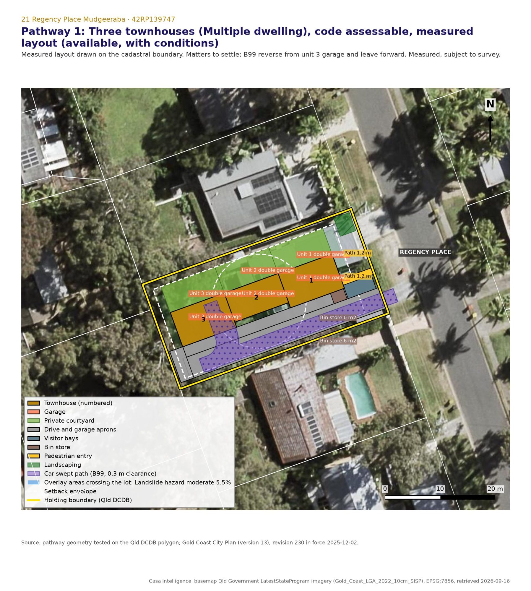
Source: pathway geometry tested on the Qld DCDB polygon; Gold Coast City Plan (version 13), revision 230 in force 2025-12-02.
Source: pathway geometry tested on the Qld DCDB polygon; Gold Coast City Plan (version 13), revision 230 in force 2025-12-02.
The alternatives
The other pathways, tested the same way
Four townhouses. The density outcome is the stop, and it is a hard one because it has no acceptable outcome to trade against. Four dwellings on 808.73 m2 is one per 202 m2 against the mapped one per 250 m2. Council accepted an overshoot of about 1 per cent next door by arguing the zone's overall outcomes; this would be about 24 per cent, and no decision within 2 km supports that. The geometry agrees with the arithmetic: a fourth unit of the same module would finish past the rear boundary, and above three dwellings the Transport code requires a service vehicle standing area on site and a forward gear exit for every vehicle, neither of which fits on a 20 m wide lot without losing a courtyard. The route to more dwellings is more land: amalgamating with one neighbour would give about 1,618 m2 and six dwellings at the same map figure.
Two dwellings as a dual occupancy. This is the fastest pathway. In this zone a Dual occupancy is accepted subject to requirements, so no development application is needed where every required outcome is met: the zone code's required outcomes for setbacks, site cover and density, the Dual occupancy code's required outcomes for frontage (at least 20 m, so the identification survey of the 20.108 m frontage matters on this pathway too), garage width and private open space, two spaces per dwelling under the Transport code, and the bushfire and landslide required outcomes. The landslide one is certification by a registered professional engineer of Queensland (RO1, rule 3986). The bushfire one is harder than it looks: RO1 (rule 3387) is met only where a consultant's written assessment confirms the site is not in a Bushfire Hazard Area, or an existing approved bushfire management plan from an approved reconfiguration applies, or the development is a dwelling house on a lot under 1,000 m2 with reticulated water. A dual occupancy is not a dwelling house, there is no approved reconfiguration on this lot, and next door at 17 Sherwood Close the consultant's report found the site was in a bushfire hazard area, so the first limb is unlikely here. Where RO1 is not met the code says RO2 to RO6 apply instead (rule 3388): bushfire radiation zones contained wholly within the site (RO2, rule 3389), the 4 m formed driveway in a 6 m cleared width at no more than 12.5 per cent (RO3, rule 3390), where the natural ground rises 13.8 per cent over the 6 m to the northern garage and 6.6 per cent to the southern on the 1 m LiDAR, so the northern garage floor sits about 0.1 m below natural ground at its door to keep that drive inside the limit (a floor level matter, subject to survey), and a reticulated supply delivering 10 litres a second at 200 kPa or dedicated fire fighting storage (RO5, rule 3392). RO2 is the requirement to settle before relying on this pathway: Council's mapping places the nearest mapped hazard class 77.5 m west of the rear boundary and 99.6 m from the dwellings (measured on Council's layer, subject to the consultant's assessment), the lot itself carries only the buffer, and the dimensions of the radiation zones are set in the bushfire management plan under policy SC6.3 because the Vegetation management code as published does not state them. Two attached dwellings fit within an 8 by 14 m envelope, 100 m2 of footprint each once the rear corner is cut back, so site cover is 24.7%, 4.0 m front setbacks to walls and 6.0 m to garages, 2.05 m sides and 42 m2 courtyards; the sides clear by 5 cm the 2 m the required outcome asks of the part of a wall between 4.5 m and 7.5 m in height, but the same outcome adds a further 0.5 m for every 3 m of wall over 7.5 m (RO1, rule 16554, the same tiers as rule 16559), so the 2.05 m holds only while the side walls top out under 7.5 m, and the identification survey matters to the dwelling width as well as to the frontage. They must share a party wall: detached dwellings on one lot need double the side setback between them, 3 m at up to 4.5 m wall height (rule 16559), and 1.5 m plus 8 m plus 3 m plus 8 m plus 1.5 m is 22 m on a lot 20.11 m wide. Miss one required outcome and the proposal does not fail: it becomes code assessable (5.3, the operating provision for accepted development), and Council's practice at 17 Sherwood Close was to assess only the outcomes not met.
One lot into two. A front lot of 312 m2 with 15.6 m of frontage and a rear lot of about 497 m2, which is 407 m2 once the 4.5 m access handle is excluded, both clear the 250 m2 minimum lot size measured exclusive of access strips (rule 16592). Reconfiguring a lot is code assessable. A house on either new lot is accepted subject to requirements, which means no application where every required outcome is met and code assessment on any that is not: on the 312 m2 front lot because it is under 400 m2 (Table 5.5.2, rule 6795), and on the rear lot, although it is over 400 m2, because the bushfire and landslide overlay tables turn a use that another table provisionally makes accepted into accepted subject to requirements with the overlay codes' required outcomes (Table 5.10.3, rule 6553; Table 5.10.14, rule 8865), and the rear lot holds 420 m2 of the bushfire buffer and the 44.6 m2 mapped landslide corner. This is the pattern Council approved at 17 Sherwood Close Mudgeeraba, and the register records a second one into three lot permit at 3A Sherwood Close (MIN/2024/302, a minor change to that permit; its notice was not read). The rear lot provisions of the Reconfiguring a lot code are met on the drawing: Table 9.4.8-2 sets a minimum access strip width of 4.5 m in the Medium density residential zone (rule 6024, applied by AO4.1, rule 5981), which is the width drawn, so a survey shortfall of even a few centimetres moves the handle to the performance outcome; AO2.1 to AO2.3 (rule 5977) ask for one rear lot, created for a dwelling house, of the same width as the lot it sits behind, and the layout draws one rear lot across the full 20.11 m width for a house. Two matters then decide it: a lawful point of discharge for stormwater from the uphill rear lot, which will need an easement through the front lot; and the same bushfire and geotechnical evidence.
Which is better depends on what you want. Three townhouses is the highest yield the map supports and the only pathway that uses the full density. Subdivision realises two titles with the least construction risk on a slope. A dual occupancy is the quickest and needs no application where the required outcomes are met.
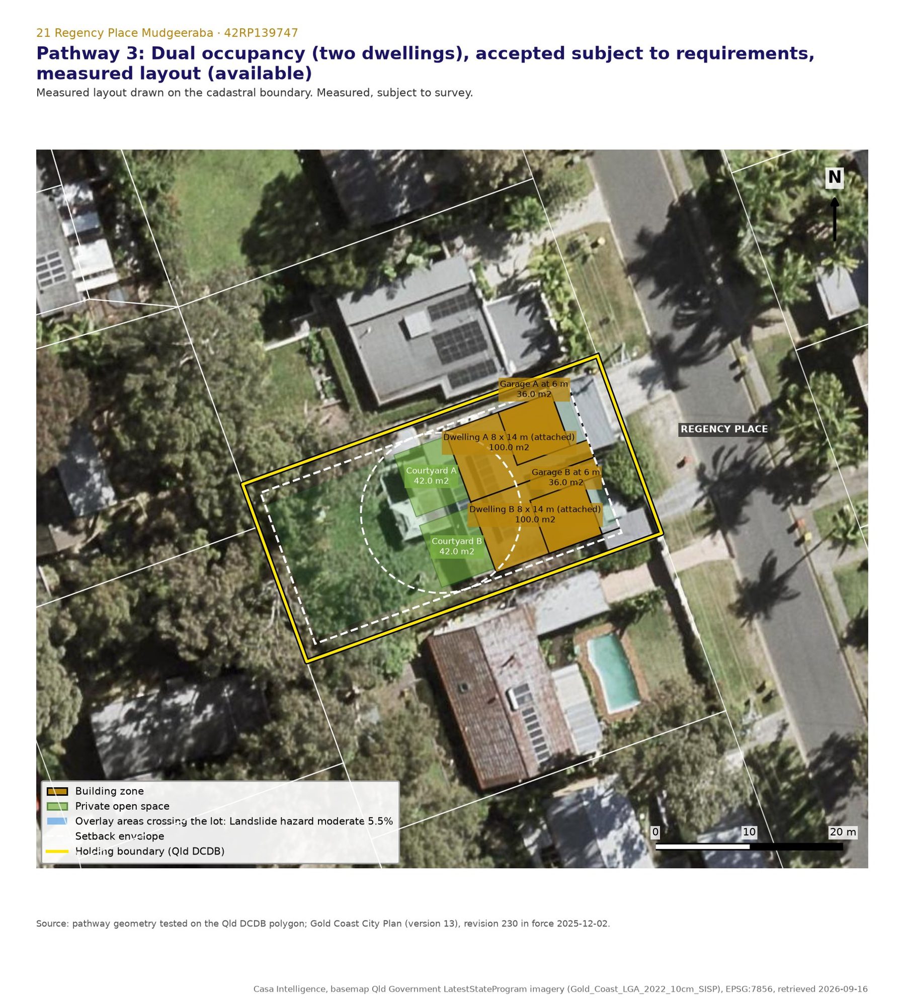
Source: pathway geometry tested on the Qld DCDB polygon; Gold Coast City Plan (version 13), revision 230 in force 2025-12-02.
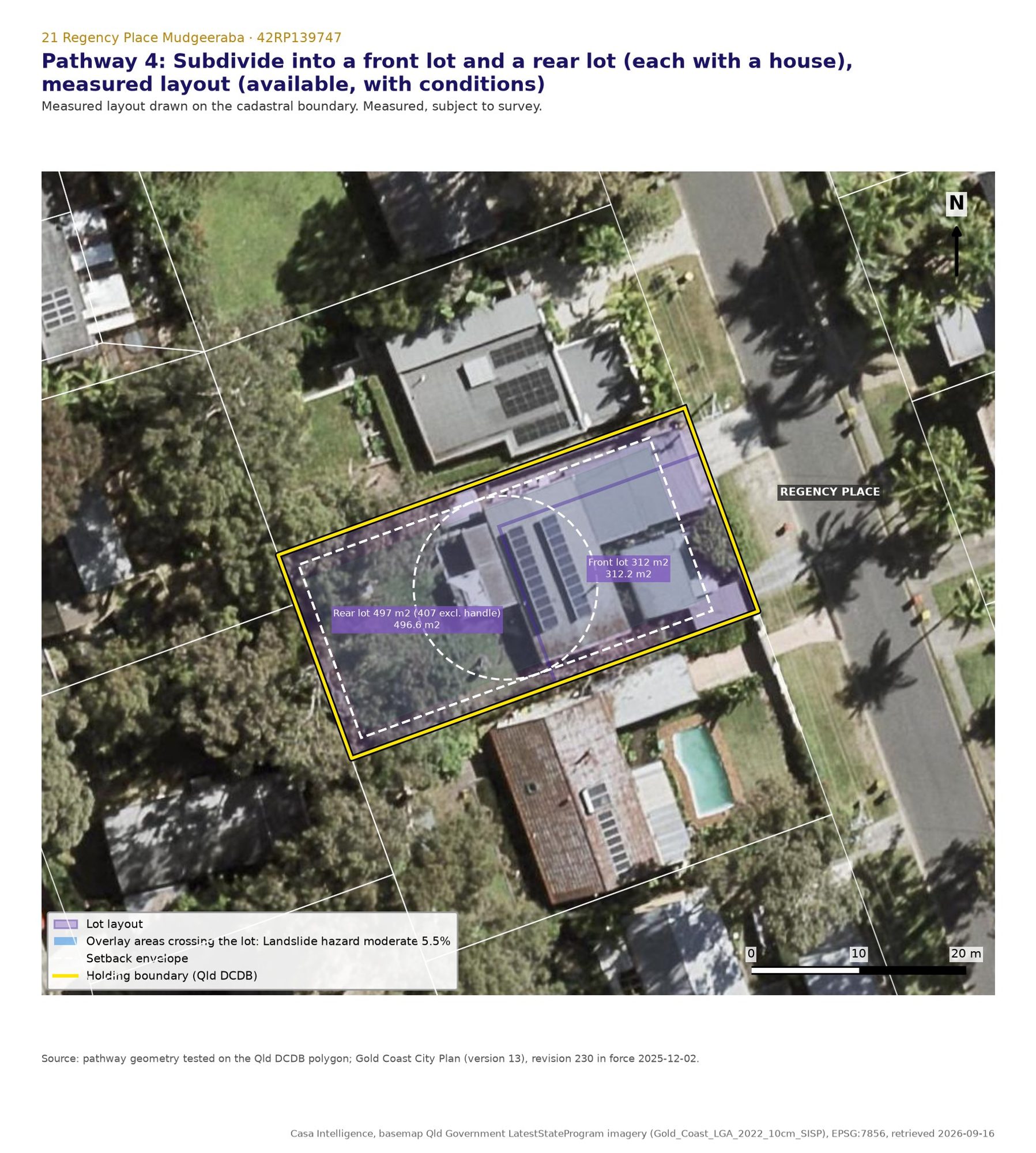
Source: pathway geometry tested on the Qld DCDB polygon; Gold Coast City Plan (version 13), revision 230 in force 2025-12-02.
Access
Access, parking and internal manoeuvring
The scheme asks for one vehicle crossing to this lot, and a second only where the kerb frontage exceeds 20 m with 7 m between the two (AO4, rule 5748), with any crossing at least 1 m from a side boundary and from a neighbour's crossing (AO5, rule 5750). The layout uses one new crossing at the southern end of the frontage, 1.0 m off the boundary, and removes the existing northern crossover. The kerb length was not measured, so one crossing is assumed.
Inside the lot the drive is 4.0 m of formed surface within a 7.0 m clear strip between the boundary and the units, which meets the bushfire code's required outcome for an access in a hazard area, 4 m formed inside 6 m cleared (RO3, rule 3390), and more than the 3.5 m the Fire services code asks (rule 5781). RO3 is the accepted development requirement; for a code assessable use the benchmark is PO6 (rule 3410), whose acceptable outcomes are written for estates, a perimeter road (AO6.1), road design to the land development guidelines (AO6.2) and no dead end roads (AO6.3), so a single dead end drive with a turning bay is assessed against PO6 through the access section of the bushfire management plan rather than through those acceptable outcomes, and RO3's numbers are the conservative test. The drive runs 37.9 m to its end, and the deepest garage door is 32.8 m from the street, well inside the 70 m limit. Parking is set by Table 9.4.13-3: 1.5 spaces for each three bedroom dwelling and 1.25 for each two bedroom dwelling, rounded up under rule 6244, plus one visitor space for three or four dwellings, giving six. The layout provides seven, six of them in three double garages and one visitor space near the street that stays unallocated and accessible at all times (rule 6208). Waste is kerbside collection, which policy SC6.16 accepts for up to five townhouses, with a 6.5 m2 bin store screened from the street.
At exactly three dwellings the Transport code switches several requirements off, and that is one reason three is the natural number on this lot. The notes to the code mean there is no requirement for a forward gear exit for every vehicle (rule 6232), no bicycle parking (rule 6220), no public footpath along the frontage (rule 6223), and no service vehicle standing area on site (rules 6346 and 6347). All four switch on above three dwellings.
The one movement still to be settled is the car leaving the deepest garage. Modelled indicatively as a B99 design car reversing out and leaving in forward gear, the turn clears every courtyard, every bay and every building, and stays on the site's own formed surface: the only part off that surface, 5.8 m2, is in the Regency Place road reserve at the crossing, where a car naturally swings as it turns out. This is a matter for a traffic engineer's swept path drawing at design stage, and it is the kind of detail Council tests: at 17 Sherwood Close Mudgeeraba the officer recorded that "the provided swept path analysis has demonstrated that a B85 vehicle is able to enter and exit all garage spaces while the adjoining space is occupied despite the non-standard aisle width". On parking numbers, Council has also accepted less than the table requires where the scale justified it: at 69 Railway Street Mudgeeraba two visitor spaces were accepted in lieu of three because "typical residential visitor parking demand would be unlikely to exceed two (2) spaces at once". Your layout is one space above the requirement, so it does not need that argument.
Practice
What Council has decided nearby, and this lot's own history
Two decisions carry real weight here and both were read from Council's own documents rather than the register summary: for COM/2024/203 the delegated officer's report, the stamped approved plans and the infrastructure charges notice, and for MCU/2021/244 the delegated officer's report, the signed decision notice and the infrastructure charges notice. Both were assessed under earlier versions of the City Plan, version 11 for COM/2024/203 and version 8 for MCU/2021/244; every provision this report quotes is read from version 13, so those decisions are practice, not the rule.
COM/2024/203 at 17 Sherwood Close Mudgeeraba is 96 m away between lot centres (about 54 m boundary to boundary), in the same zone, on the same bushfire and landslide overlays, on a sloping lot with the same 20 m frontage and the same 2 storey and 9 m height. Council approved a one into three lot subdivision with three dual occupancies, six dwellings on 1,481 m2, with site cover of 33.3%, 40.7%, 26.4% per lot on the three lots and two spaces per dwelling. It shows Council accepting density slightly over the map figure, setback encroachments at building corners, rear dwellings that address an internal drive, a bushfire management plan and a geotechnical report by a registered engineer as the overlay route, and property notifications on the title for slope and bushfire. MCU/2021/244 at 69 Railway Street Mudgeeraba is the nearest decided townhouse form Multiple dwelling, five dwellings approved in 2021 in the Centre zone, so its setbacks and density are not this site's benchmarks, but its form, its two storey height and its visitor parking finding are instructive.
A caution about how much this proves. No Multiple dwelling application in the Medium density residential zone has been decided within 2 km since 2019, and fewer than ten same class approvals exist in the district, so there is no like for like decision that says three townhouses on an 809 m2 lot in Regency Place will be approved. What supports three is the scheme's own arithmetic, tested outcome by outcome. We also found no refusal of a Multiple dwelling or Dual occupancy within 2 km in that period.
This lot's own history is short: two building approvals, for additions and an open carport and for alterations and additions, and no material change of use approval. The lawful use is a dwelling house. Demolishing a house that is not heritage listed and carries no character overlay is accepted development, although a building approval for the demolition is still required.
| Application | Address | Distance | Proposal | Outcome | Decided |
|---|---|---|---|---|---|
| COM/2024/203 | 17 Sherwood Close Mudgeeraba | 96 m | Combined ROL 1 into 3 lots (487, 380, 613 m2 incl. access easement) and MCU Dual occupancy x 3 (6 dwellings) | Approved with conditions | 17 December 2025 |
| MCU/2021/244 | 69 Railway Street Mudgeeraba | 530 m | Multiple dwellings (5 units: three 2-storey attached townhouses and two single storey units on a podium) with an existing Food and drink outlet | Approved with conditions | 25 November 2021 |
| MIN/2024/302 | 3A Sherwood Close Mudgeeraba | 104 m | Minor change to a development permit for a one into three lot subdivision | Decided | 29 July 2024 |
| ROL/2023/33 | 18 Eclipse Court Mudgeeraba | 318 m | Reconfiguring a lot, code assessment | Approved on the register | 31 October 2023 |
| COM/2025/150 | 1 Satellite Court Mudgeeraba | 478 m | Combined application for three dwellings, publicly notified with submissions | Undecided | not yet decided |
| MCU/2025/480 | 49 Railway Street Mudgeeraba | 369 m | Outdoor and Indoor sport and recreation and Park (Council pool) | Approved with conditions | 29 December 2025 |
Next
What to do next, in order of leverage
1. Commission an identification and detail survey. It settles the 20.108 m frontage against the 20 m acceptable outcome, which is the single number closest to the line in this report, and it replaces 2014 LiDAR levels with real ones for the driveway grade, the split levels and the retaining. Everything else is cheaper to decide after it.
2. Order a title search. No easement shows on the cadastre, but covenants, building envelopes and other encumbrances only appear on the title, and they bind the design regardless of what the scheme allows.
3. Get the two specialist reports early, not late. A bushfire management plan to policy SC6.3 and a geotechnical stability assessment to policy SC6.10 by a registered professional engineer of Queensland are the two documents Council conditioned next door. Their findings can move a wall or a floor level, so they are worth having before the drawings are finished rather than after.
4. Have a traffic engineer draw the swept paths for the deepest garage and the crossing. It is the only tested matter that did not come back clean, and a slightly wider apron at the rear garage or a recessed door is the usual answer.
5. Ask Council for a pre lodgement meeting once those are in hand, and put the orientation of the rear units and the frontage measurement on the agenda. Both are performance outcome matters where an officer's early view is worth having in writing.
6. Then lodge one development application for a material change of use for a Multiple dwelling, code assessable, with a site analysis plan, a statement of landscape intent, a stormwater management plan, the bushfire management plan and the geotechnical report. After the decision, building approval, plumbing approval and a vehicle crossing licence follow, and the infrastructure charges notice issues with the decision.
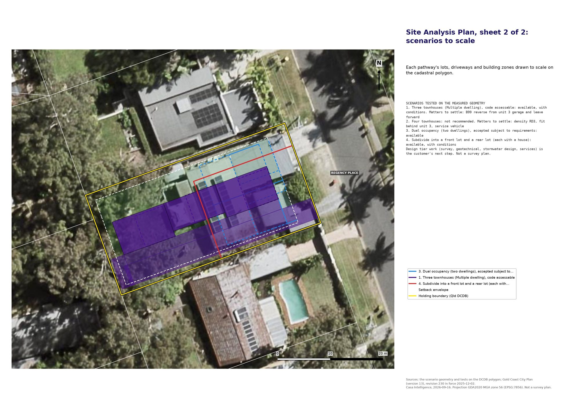
the scenario geometry and tests
Risk
What could change this answer
Nothing in this report depends on a fact we could not check, but several things depend on facts that only a survey, a title search or a specialist report can settle. Each is listed with how likely it is, what it would change and how it is closed out.
| Risk | How likely, and on what basis | What it would change | How it is closed |
|---|---|---|---|
| The frontage measures under 20 m on survey | Possible: the cadastre gives 20.108 m and carries 0.1 m accuracy | The 20 m acceptable outcome for a Multiple dwelling would not be met, so frontage moves to the performance outcome about safe access and landscaping | Identification survey. Council approved a development at exactly 20 m of frontage 96 m away, so the performance route is realistic |
| The geotechnical report requires more retaining or deeper footings | Likely to some degree: mean slope is 13.5 per cent and 40 per cent of the lot is steeper than 15 per cent | Cost and floor levels move; cut or fill over 1.2 m at a boundary must be terraced | Commission the report before the drawings are finished |
| The bushfire management plan asks for wider separation to the canopy | Possible: the buffer covers the rear 54.3 per cent of the lot | The rear unit or its courtyard may need to move forward, or vegetation management at the rear boundary | Prepare the plan early; Council conditioned exactly this next door |
| A title covenant or easement restricts the built form | Unknown: the title was not searched | Estate covenants commonly restrict dwelling form and materials, and an easement can sterilise part of the lot | Title search |
| The swept path for the rear garage does not resolve on the drawn geometry | Possible: the modelled turn reaches into the road at the crossing | A wider apron, a recessed garage door or a small change to the turning bay | Traffic engineer's swept path at design stage |
| Council seeks a fourth dwelling argument or the applicant pushes for one | Not supported: density has no acceptable outcome | An application for four would be assessed against the zone's overall outcomes with a large overshoot and no nearby decision behind it | Keep the yield at three, or acquire adjoining land |
| The scheme changes before lodgement | Possible: the version read was made in force on 2 December 2025 | Categories, density or codes could change | Re-check the tables in force at the date of lodgement |
Honesty layer
What this report does not cover
- The title was not searched. Easements, covenants, building envelopes and any other encumbrance registered on the title are unknown until a title search is done, and they bind the design whatever the planning scheme allows. Where a lot forms part of an estate subdivision, estate covenants commonly restrict dwelling form, materials and siting and must be read before design.
- Boundaries and area are the State digital cadastre, which carries an accuracy of about 0.1 m here. The frontage of 20.108 m passes the 20 m acceptable outcome by 0.1 m, which is inside that tolerance, so an identification survey is required before lodgement.
- Ground levels are the Queensland 1 m LiDAR flown in 2014, and the canopy at the rear was measured from 2022 imagery. Neither replaces a detail survey and an arborist's assessment.
- The kerb length along the frontage was not measured, so a single vehicle crossing is assumed; a second crossing is only available where the kerb frontage exceeds 20 m with 7 m between the two.
- The location of the nearest fire hydrant is not known. The Fire services code only applies where a dwelling is more than 90 m from a hydrant, which is unlikely on a lot 40 m deep, but it has not been confirmed with Council's water records.
- The swept path for a car leaving the deepest garage is an indicative single model, not a traffic engineer's analysis, and a forward gear exit is not required at three dwellings in any event.
- The rear lot provisions of the Reconfiguring a lot code were read (rules 5977 and 5981 and Table 9.4.8-2, rule 6024): the 4.5 m access handle drawn equals the 4.5 m minimum for the Medium density residential zone, so the identification survey matters to the handle width as it does to the frontage.
- The two storey building form is a design assumption for height: a ridge under 9 m is achievable for the module drawn, but height has no acceptable outcome and is proved by the drawings at application stage.
- One Council mapping service, the annotation layer for airport obstacle limitation surfaces, returned an error when queried. The obstacle limitation surface polygons themselves were queried and are clear of this lot; the annotations are labels only. The level of the PANS-OPS height limitation surface over this lot was not read, because the mapping layer and Table 5.10.2 carry none, and the window positions of the neighbouring houses were not surveyed; both are named where they arise in sections 4 and 6.
- State bushfire and landslide hazard mapping was not queried directly from the State service. The City Plan integrates the State Planning Policy natural hazards and its overlay codes are the benchmarks for code assessment, so the Council mapping governs the assessment.
- The existing house's construction date and plans are not held. Demolition is treated as accepted development because no heritage or character overlay applies to this lot; a building approval for demolition is still required.
- Fewer than ten same class approvals exist in this district, and no Multiple dwelling in this zone has been decided within 2 km since 2019. Yields above three dwellings are untested here, and the three dwelling figure rests on the scheme's own numbers rather than on a like for like decision.
- Infrastructure charge figures are the published base rates of the current charges resolution and the rates actually levied on a nearby approval in December 2025. The amount payable is set by the notice Council issues with the decision, after indexation and after the credit for the existing lawful use.
Deterministic site plan
Site Analysis Plan
This is a real Casa Intelligence report, prepared on a real property using public planning and cadastral data. The property was selected from public listing and development-application records and we have no connection with its owner. Prepared 21 September 2026 against the planning scheme in force on that date.
Pre-delivery audit and planner pass recorded 21 September 2026. Site-constraint gate for the modelled scenario (townhouses): pass. If you are the owner of this property and would like this page removed, email hello@casaintelligence.com.au and it comes down within two business days, no questions asked.
This report is an assessment of record prepared by Casa Intelligence Pty Ltd from the primary sources cited in it: the planning scheme in force on the date shown, Council's own mapping services queried against the lot boundary, the State digital cadastre and elevation data, and Council's own decision documents. It is general planning information, not planning or legal advice, and it is not a guarantee that any application will be approved. The assessment of a development application is a matter for the assessment manager on the material before it. Casa Intelligence does not act as the planner of record for any application arising from this report. No site inspection, title search or survey was undertaken.